
Stung Treng province facts for kids
Quick facts for kids
Stung Treng
|
||
|---|---|---|
| Stung Treng Province ខេត្តស្ទឹងត្រែង (Khmer) จังหวัดสตึงแตรง (Thai) ແຂວងຊຽງແຕង (Lao) |
||
_Mekong_Cambodia_4172.jpg)
Sopheakmitt Waterfall
|
||
|
||

Map of Cambodia highlighting Stung Treng
|
||
| Country | ||
| Provincial status | 1907 | |
| Capital | Stung Treng | |
| Subdivisions | 1 municipality; 5 districts | |
| Area | ||
| • Total | 11,092 km2 (4,283 sq mi) | |
| Area rank | Ranked 8th | |
| Population
(2019)
|
||
| • Total | ||
| • Rank | 21st | |
| • Density | 14/km2 (40/sq mi) | |
| • Density rank | 23rd | |
| Demographics | ||
| • Language(s) | ||
| Time zone | UTC+07:00 (ICT) | |
| Dialing code | +855 | |
| ISO 3166 code | KH-19 | |

Stung Treng is a province located in the northeast part of Cambodia. Its name means "River of Reeds." The province shares a border with Laos to the north. It also borders other Cambodian provinces like Ratanakiri to the east and Kratié to the south.
The mighty Mekong River flows right through the middle of Stung Treng. Most of the province is covered by thick forests. However, activities like logging and fishing are putting pressure on these natural resources.
Contents
What's in a Name? The Story of Stung Treng
The area now known as Stung Treng was first called "Tonle Ropov." This name is still used for a specific area within the province today.
Later, a monk from Vientiane named Seang Peng gave it a new name: "Satung Teng." This name eventually changed to "Xiang Taeng." In the Lao language, "Xiang" means "goddess" and "Taeng" means "built."
Over time, as the Khmer language developed, the name became "Stung Treng." This modern name means "river of reeds," which describes the local environment.
A Look Back: Stung Treng's History
Stung Treng has a long and interesting history. It was once part of the powerful Khmer Empire. Later, it became part of the Lao kingdom of Lan Xang. After that, it was part of the Lao kingdom of Champasak.
In 1904, something important happened. The French, who controlled parts of Southeast Asia, traded Stung Treng. It moved from being part of French Laos to being part of the French Protectorate of Cambodia. This trade left a small group of Laotian people living in Cambodia.
Because of its location near the border and its forested mountains, the province saw some conflict in the 1960s and 70s. This period of unrest lasted until the later years of the Khmer Rouge era.
Exploring Stung Treng's Geography
Stung Treng province covers a large area of about 11,092 square kilometers. It shares borders with Laos to the north and Ratanakiri to the east. To the west, it borders Preah Vihear. To the south, you'll find Kratié and Kampong Thom.
The province is known for its vast forests and many rivers and streams. A part of the huge Virachey National Park is also located here. You can reach this park from Siem Pang.
Stung Treng is home to three major rivers: the Sekong River, the Sesan River, and the Mekong River. The Mekong River here has hundreds of small islands scattered along its path.
Until recently, you could sometimes spot the rare Irrawaddy dolphin in the wild near the Laos border. Sadly, due to certain activities, their numbers have greatly decreased in this area.
Understanding Stung Treng's Weather
Stung Treng experiences hot weather all year round. The temperature usually ranges from about 20°C (67°F) to 38°C (100°F). It rarely gets colder than 16°C (61°F) or hotter than 40°C (105°F).
Climate Patterns in Stung Treng
The province has a wet season and a dry season. The wet season is from May to October, with a lot of rain. July is usually the wettest month. During this time, the sky is often cloudy.
The dry season is from January to March and in December. January is the driest month. April is the warmest month, with average temperatures around 35°C (95°F). January is the coldest month, with an average temperature of 18°C (64°F).
| Climate data for Stung Treng province | |||||||||||||
|---|---|---|---|---|---|---|---|---|---|---|---|---|---|
| Month | Jan | Feb | Mar | Apr | May | Jun | Jul | Aug | Sep | Oct | Nov | Dec | Year |
| Record high °C (°F) | 36.1 (97.0) |
37.2 (99.0) |
38.3 (100.9) |
40.6 (105.1) |
38.9 (102.0) |
37.2 (99.0) |
38.9 (102.0) |
38.9 (102.0) |
33.9 (93.0) |
33.9 (93.0) |
34.4 (93.9) |
33.9 (93.0) |
40.6 (105.1) |
| Mean daily maximum °C (°F) | 31.1 (88.0) |
32.8 (91.0) |
34.4 (93.9) |
35.0 (95.0) |
32.8 (91.0) |
31.7 (89.1) |
30.6 (87.1) |
30.6 (87.1) |
30.0 (86.0) |
30.0 (86.0) |
30.0 (86.0) |
29.4 (84.9) |
31.5 (88.7) |
| Daily mean °C (°F) | 25.0 (77.0) |
26.7 (80.1) |
28.9 (84.0) |
30.0 (86.0) |
28.6 (83.5) |
27.8 (82.0) |
27.0 (80.6) |
27.2 (81.0) |
26.7 (80.1) |
26.4 (79.5) |
25.8 (78.4) |
24.2 (75.6) |
27.0 (80.6) |
| Mean daily minimum °C (°F) | 18.9 (66.0) |
20.6 (69.1) |
23.3 (73.9) |
25.0 (77.0) |
24.4 (75.9) |
23.9 (75.0) |
23.3 (73.9) |
23.9 (75.0) |
23.3 (73.9) |
22.8 (73.0) |
21.7 (71.1) |
18.9 (66.0) |
22.5 (72.5) |
| Record low °C (°F) | 9.4 (48.9) |
11.1 (52.0) |
17.2 (63.0) |
20.0 (68.0) |
18.9 (66.0) |
19.4 (66.9) |
20.0 (68.0) |
19.4 (66.9) |
18.9 (66.0) |
17.2 (63.0) |
11.7 (53.1) |
10.0 (50.0) |
9.4 (48.9) |
| Average precipitation mm (inches) | 2.5 (0.10) |
12.7 (0.50) |
27.9 (1.10) |
83.8 (3.30) |
203.2 (8.00) |
276.9 (10.90) |
337.8 (13.30) |
309.9 (12.20) |
325.1 (12.80) |
188.0 (7.40) |
61.0 (2.40) |
12.7 (0.50) |
1,841 (72.48) |
| Source: Sistema de Clasificación Bioclimática Mundial | |||||||||||||
Stung Treng's Economy: How People Make a Living
The economy of Stung Treng mainly relies on agriculture. Many plantations grow timber, rubber, and nuts. About 85% of the people in the province live in rural areas. They depend on farming for their income.
Other important activities include raising animals, fishing, and weaving silk. These industries also help the local economy.
In 2019, a Japanese company found signs of copper and zinc in the province. They are planning to explore more to see if these minerals can be taken out of the ground. This exploration site is about 260 kilometers north of Phnom Penh.
How Stung Treng is Governed: Administration
Stung Treng province is divided into smaller areas to help manage it. It has 5 districts and 1 main municipality (a city area). These are further split into 34 communes and 128 villages.
| ISO code | District | Khmer |
|---|---|---|
| 19-01 | Sesan | ស្រុកសេសាន |
| 19-02 | Siem Bouk | ស្រុកសៀមបូក |
| 19-03 | Siem Pang | ស្រុកសៀមប៉ាង |
| 19-04 | Stung Treng Municipality | ក្រុងស្ទឹងត្រែង |
| 19-05 | Thala Barivat | ស្រុកថាឡាបរិវ៉ាត់ |
| 19-06 | Borei O'Svay Sen Chey | ស្រុកបុរីអូរស្វាយសែនជ័យ |
Two of these districts, Siem Bouk and Thala Barivat, are located west of the Mekong River.
Famous People from Stung Treng
- Ken Lo – A martial artist, actor, and stuntman.
- Sinn Sisamouth – A well-known singer-songwriter.
Images for kids
-

Sopheakmitt Waterfall
-
Stung Treng seal
-
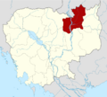
Map of Cambodia highlighting Stung Treng
See also
 In Spanish: Provincia de Stung Treng para niños
