Ratanakiri province facts for kids
Quick facts for kids
Ratanakiri
រតនគិរី
|
||
|---|---|---|
| Ratanakiri Province ខេត្តរតនគិរី |
||
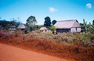
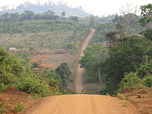
Ratanakiri countryside
|
||
|
||
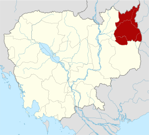
Location of Ratanakiri in Cambodia
|
||
| Country | ||
| Established | 1959 | |
| Capital | Banlung | |
| Subdivisions | 1 municipality; 8 districts | |
| Area | ||
| • Total | 10,782 km2 (4,163 sq mi) | |
| Area rank | 9th | |
| Population
(2019)
|
||
| • Total | ||
| • Rank | 20th | |
| • Density | 19/km2 (50/sq mi) | |
| • Density rank | 21st | |
| Time zone | UTC+07:00 (ICT) | |
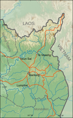
Ratanakiri (Khmer: រតនគិរី, meaning "Gem Mountains") is a province in northeast Cambodia. It shares borders with Mondulkiri and Stung Treng provinces in Cambodia. It also borders Laos and Vietnam. The province stretches from mountains in the north to tropical forests in the south. Ratanakiri is known for its beautiful natural areas.
For over a thousand years, Ratanakiri has been home to the Khmer Loeu people. These are highland groups who are a minority in other parts of Cambodia. In the past, people from other empires sometimes took Khmer Loeu as slaves. This practice ended when the French took control. Later, after Cambodia became independent, there were efforts to make the Khmer Loeu adopt Khmer culture. This threatened their traditional way of life.
In the 1960s, the Khmer Rouge group set up their main base in Ratanakiri. The area was also affected by bombing during the Vietnam War. Today, Ratanakiri is changing quickly. New developments are affecting the traditional lives of its people. The province has about 184,000 residents, which is a small part of Cambodia's total population. Most people live in small villages and grow their own food. Ratanakiri is one of Cambodia's less developed provinces. It has limited roads and services.
Contents
History of Ratanakiri
Ratanakiri has been lived in since the Stone Age or Bronze Age. People from the highlands traded with towns along the Gulf of Thailand as early as the 4th century A.D. Different empires tried to control the region in early history, but none fully succeeded. For many centuries, villages in the highlands were often raided by slave traders.
The area became part of French Indochina in 1893. French rule stopped the slave trade. The French built large rubber farms, especially in Banlung. Local workers helped build and harvest rubber. During French control, the land that is now Ratanakiri was moved between Siam (Thailand), Laos, and then Cambodia.
Forming the Province
Ratanakiri Province was officially created in 1959. It was formed from the eastern part of Stung Treng Province. The name Ratanakiri comes from Khmer words meaning "gem" and "mountain." This describes two important features of the province. In the 1950s and 1960s, Cambodia's leader, Norodom Sihanouk, tried to develop the northeast. He wanted to bring villages under government control and modernize local communities. Some Khmer Loeu people were moved to other areas to learn Khmer language and culture. Roads and large rubber farms were built. Many Khmer Loeu left their homes because of hard working conditions. In 1968, there was an uprising by the Brao people. The government responded by burning villages.
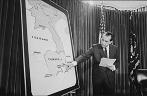
In the 1960s, the Khmer Rouge group worked with ethnic minorities in Ratanakiri. They used the Khmer Loeu's unhappiness with the government. The Khmer Rouge headquarters moved to Ratanakiri in 1966. Many Khmer Loeu joined their groups. There was also a lot of Vietnamese activity in Ratanakiri. From 1969 to 1970, the United States bombed the region. This was to disrupt bases for Vietnamese troops. Villagers had to leave their homes to escape the bombings. In 1970, the government left Ratanakiri, and the Khmer Rouge took control.
The Khmer Rouge rule became very strict. Khmer Loeu people were not allowed to speak their languages or practice their traditions. Schools were closed. Many people fled to Vietnam and Laos.
Recent Changes
After the Cambodian-Vietnamese War in 1979, the government allowed the Khmer Loeu to return to their traditional lives. However, there was little new development in the province. Khmer Rouge rebels stayed in Ratanakiri's forests for many years. Most rebels gave up their weapons in the 1990s.
Ratanakiri has seen a lot of development recently. The government has built roads and encouraged tourism and farming. More people from other parts of Cambodia have moved to Ratanakiri. This has caused land prices to go up. Sometimes, local communities have lost their traditional lands. However, with help from international groups, this problem has become less common.
Geography and Climate
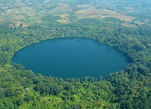
Ratanakiri Province has many different types of land. These include rolling hills, mountains, flat plateaus, and crater lakes. Two main rivers, Tonle San and Tonle Srepok, flow through the province. Ratanakiri is known for its thick forests. In 1997, about 70–80% of the province was covered in forests.
In the far north are the Annamite Range mountains. This area has dense broadleaf evergreen forests and lots of wildlife. In the highlands, where most people live, there is a hilly area with fertile red soil. South of the Srepok River, the land is flat with tropical deciduous forests.
Weather Patterns
Like other parts of Cambodia, Ratanakiri has a monsoon climate. It has a rainy season from June to October. There is a cool season from November to January, and a hot season from March to May. Ratanakiri is usually cooler than other places in Cambodia. The average high temperature is about 34.0°C (93.2°F). The average low temperature is about 22.1°C (71.8°F). It rains about 2200 mm (87 inches) each year. Flooding often happens during the rainy season.
Ratanakiri has many different kinds of plants and animals. It has some of the most biologically diverse rainforests in Southeast Asia. Surveys have found many species of mammals, birds, reptiles, fish, and amphibians. This includes Asian elephants, gaur, and monkeys. Ratanakiri is also important for protecting endangered birds like the giant ibis. The forests have a wide variety of trees and plants.
Nearly half of Ratanakiri is protected land. This includes Lomphat Wildlife Sanctuary and Virachey National Park. However, even these areas face challenges. There are problems with cutting down trees, hunting animals, and digging for minerals. While the province was once known for its untouched nature, recent changes have caused environmental issues. Habitat loss and too much hunting are reducing the number of different species.
Government and Administration
The government in Ratanakiri is not very strong. This is because the province is far away, has many different ethnic groups, and was controlled by the Khmer Rouge in the past. Government services are not always effective. The Cambodian government often gets help from NGOs (non-governmental organizations) in the region.
Local Leadership
Villages in Ratanakiri have both traditional and official leaders. Traditional leaders are often village elders. They manage village matters, help solve problems, and make sure people follow old customs. Elders are usually respected advisors. While most elders are men, women also help manage the community. A village may also have a village chief. This person is appointed by the government. The village chief connects the village with outside government officials. However, they do not have the same traditional authority as the elders.
Provincial Divisions
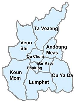
The province is divided into eight districts and one municipality. These are further divided into 50 communes.
| ISO Code | District | Communes | Population (2019) |
|---|---|---|---|
| 1601 | Andoung Meas | Malik, Nhang, Ta Lav | 17,617 |
| 1602 | Banlung Municipality | Kachanh, Labansiek, Yeak Laom, Boeng Kansaeng | 30,399 |
| 1603 | Bar Kaev | Kak, Keh Chong, La Minh, Lung Khung, Saeng, Ting Chak | 28,279 |
| 1604 | Koun Mom | Serei Mongkol, Srae Angkrorng, Ta Ang, Teun, Trapeang Chres, Trapeang Kraham | 30,810 |
| 1605 | Lumphat | Chey Otdam, Ka Laeng, Lbang Muoy, Lbang Pir, Ba Tang, Seda | 27,839 |
| 1606 | Ou Chum | Cha Ung, Chan, Aekakpheap, Kalai, Ou Chum, Sameakki, L'ak | 25,301 |
| 1607 | Ou Ya Dav | Bar Kham, Lum Choar, Pak Nhai, Pate, Sesant, Saom Thum, Ya Tung | 23,932 |
| 1608 | Ta Veaeng | Ta Veaeng Leu, Ta Veaeng Kraom | 7,503 |
| 1609 | Veun Sai | Ban Pong, Hat Pak, Ka Choun, Kaoh Pang, Kaoh Peak, Kok Lak, Pa Kalan, Phnum Kok, Veun Sai | 27,210 |
Economy and Travel
Most people in Ratanakiri work in agriculture. Many indigenous residents are subsistence farmers. This means they grow food mainly for themselves and their families. They often use a method called slash and burn shifting cultivation. Some families are now starting to grow crops to sell, like cashews, mangoes, and tobacco.
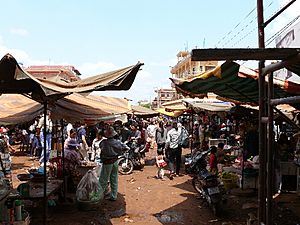
In the past, Ratanakiri villagers did not use much money. They often traded goods instead. Now, things like motorcycles and televisions are very popular. Larger farms grow rubber and cashews. Other ways people earn money include digging for gems and cutting timber. The most common gem found is blue zircon. Small amounts of amethyst and sapphire are also found. Gems are usually mined by hand.
Ratanakiri's tourism has grown quickly. Many visitors come to see the natural beauty. The area focuses on ecotourism, which means tourism that protects nature. However, local communities often do not earn much from tourism. Sometimes, tourists visit villages without permission, which can disturb local life. Efforts are being made to make tourism more helpful for local people.
Ox-carts and motorcycles are common ways to travel in Ratanakiri. The roads are getting better, but some are still rough. A new road was built between Banlung and the Vietnam border. This road is expected to increase trade. There is a small airport in Banlung, but regular flights have stopped.
People and Towns
As of 2013, Ratanakiri Province had about 184,000 people. Its population almost doubled between 1998 and 2013. This was mostly because people moved there from other parts of Cambodia. About 70% of the people live in the highlands. The capital, Banlung, is the largest town with about 25,000 people. Other important towns are Veun Sai and Lomphat.
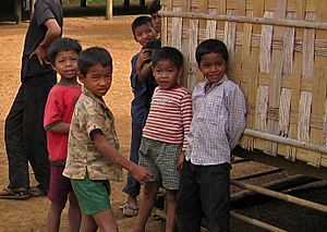
In 2013, about half of Ratanakiri's population was made up of different highland groups called Khmer Loeu. Ethnic Khmers made up 36%, and ethnic Lao made up 10%. The Khmer Loeu include groups like the Tampuan, Jarai, and Kreung. Each indigenous group speaks its own language. Less than 10% of the indigenous people can speak Khmer fluently. There are also small groups of Vietnamese, Cham, and Chinese people.
Health, Education, and Development
Health in Ratanakiri faces many challenges. Many people get sick from diseases like malaria and tuberculosis. There are also high rates of illness among mothers and children. These health issues are due to poverty, villages being far away, and limited medical services. Language and cultural differences can also make it hard for Khmer Loeu people to get medical help. The province has one main hospital and several health centers.
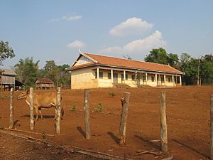
Education levels are low, especially among the Khmer Loeu. Many people have not attended primary school. It can be hard to go to school because of the cost of books, the distance to schools, and children needing to help their families. Also, lessons are often in Khmer, which is not the first language for many students.
Bilingual education programs started in Ratanakiri in 2002. In these programs, students first learn in their native languages. Then, they slowly switch to learning in Khmer. These programs have been successful. They help indigenous students access education and learn Khmer. This helps them participate in national life.
Ratanakiri is one of the less developed provinces in Cambodia. Many homes have few rooms. Most buildings do not have strong roofs, walls, or floors. Few homes have toilets. Many people get water from springs, streams, or rain. Only a small number get water from safe sources. Most homes use firewood for cooking. Many NGOs work in the province to improve health and living conditions.
Culture and Traditions
Khmer Loeu people usually grow their own food using slash and burn shifting cultivation. They live in small villages of 20 to 60 families. Each village owns and manages a forest area together. Within this land, each family gets a piece of land to farm. This farming method is sustainable and usually lasts 10 to 15 years. Villagers also hunt, fish, and gather food from the forest.
Food and Diet
The food Khmer Loeu people eat depends on what they can harvest or gather. They mostly eat rice. However, many families run out of rice before the next harvest. Some families now plant maize to help with this. Other foods include potatoes, cassava, and taro. Their diet is often low in protein. Wild animals and fish are important protein sources. Domestic animals like pigs and cows are only eaten during special ceremonies. In the rainy season, many types of vegetables and leaves are gathered from the forest. Fruits like bananas and mangoes are also common.
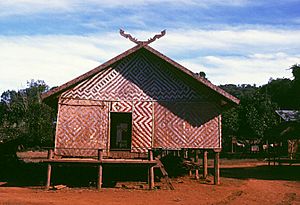
Houses in rural Ratanakiri are made from natural materials like bamboo and wood. These materials are gathered from nearby forests. Houses usually last about three years. The way villages are set up can differ by ethnic group. For example, Kreung villages are built in a circle, with houses facing a central meeting house. Jarai villages have large longhouses where many families live together.
Beliefs and Customs
Almost all Khmer Loeu people are animist. This means they believe that spirits live in nature. Some forests are thought to be home to local spirits. It is forbidden to cut trees in these sacred areas. Certain natural features like rocks, waterfalls, and pools are also considered sacred. Important festivals happen in March and April. These are when fields are chosen and prepared for planting.
Some Christian missionaries are in the province, and some Khmer Loeu have become Christian. However, some indigenous leaders see missionaries as a threat to their society. The ethnic Khmer people in the region are Buddhist. There is also a small Muslim community, mostly made up of ethnic Cham people.
Ratanakiri was quite isolated from Western influences until recently. This was due to malaria and its distance from major cities. However, big cultural changes have happened in recent years. This is especially true in villages near roads and towns. These changes are due to contact with new people, government officials, and NGO workers. Clothing and diets are becoming more similar to other areas. Traditional music is being replaced by Khmer music.
See also
 In Spanish: Provincia de Ratanak Kirí para niños
 | Frances Mary Albrier |
 | Whitney Young |
 | Muhammad Ali |


