Sunol, Nebraska facts for kids
Quick facts for kids
Sunol, Nebraska
|
|
|---|---|

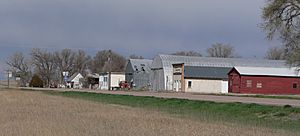
Downtown Sunol: north side of U.S. Highway 30/385
|
|
| Country | United States |
| State | Nebraska |
| County | Cheyenne |
| Area | |
| • Total | 2.19 sq mi (5.67 km2) |
| • Land | 2.19 sq mi (5.66 km2) |
| • Water | 0.00 sq mi (0.01 km2) |
| Elevation | 3,924 ft (1,196 m) |
| Population
(2020)
|
|
| • Total | 57 |
| • Density | 26.06/sq mi (10.06/km2) |
| Time zone | UTC-7 (Mountain (MST)) |
| • Summer (DST) | UTC-6 (MDT) |
| Area code(s) | 308 |
| GNIS feature ID | 2583899 |
Sunol is a small community located in Cheyenne County, Nebraska, in the United States. It is known as an unincorporated community and a census-designated place. This means it's a recognized area for counting people during a census, even though it doesn't have its own local government like a city or town.
In 2020, about 57 people lived in Sunol. The community is found in the valley of Lodgepole Creek. It's also situated along two important roads, U.S. Route 30 and U.S. Route 385. Sunol is about 11 miles east of Sidney, which is the main town of Cheyenne County. You can also reach Sunol easily from Interstate 80, which is about 3 miles to the south.
A Look Back at Sunol's History
Sunol was officially planned out and marked on a map in 1909. This process is called "platting," which means creating a map of a piece of land showing its boundaries and divisions.
A post office was opened in Sunol in 1910. This was an important service for the community, allowing people to send and receive mail. The post office served the residents of Sunol for many years before it was closed in 1973.
Understanding Sunol's Population
This section talks about the "demographics" of Sunol. Demographics are facts about a population, like how many people live there and how that number changes over time.
The United States government counts the population every ten years in what is called a "decennial census." This helps us understand how communities are growing or shrinking.
| Historical population | |||
|---|---|---|---|
| Census | Pop. | %± | |
| 2020 | 57 | — | |
| U.S. Decennial Census | |||
In 2020, the census showed that 57 people lived in Sunol. This number helps us see the size of the community.
See also
 In Spanish: Sunol (Nebraska) para niños
 | Janet Taylor Pickett |
 | Synthia Saint James |
 | Howardena Pindell |
 | Faith Ringgold |


