
Suntrana, Alaska facts for kids
Quick facts for kids
Suntrana, Alaska
|
|
|---|---|
|
Ghost town
|
|

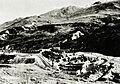
Mine plant and Alaska Railroad tracks, mid 1950s.
|
|

Suntrana, Alaska
Location in Alaska
|
|
| Country | United States |
| State | Alaska |
| Borough | Denali |
| Elevation | 1,463 ft (446 m) |
| Time zone | UTC-9 (Alaska (AKST)) |
| • Summer (DST) | UTC-8 (AKDT) |
| GNIS feature ID | 1410410 |
Suntrana was once a small community in Alaska, United States. It was located in the eastern part of Denali Borough. Today, Suntrana is known as a ghost town, meaning it is no longer an active community. It is now part of a larger area called Healy.
Contents
Where Was Suntrana Located?
Suntrana was found off the George Parks Highway. This road is south of the city of Anderson. It was also on the edge of Denali National Park and Preserve. The area is about 1,463 feet (446 meters) above sea level. Suntrana was located next to the Healy River, about 3.5 miles (5.5 km) east of Healy. Healy is the main town, or borough seat, of the Denali Borough.
Why Suntrana Became a Ghost Town
Suntrana was once a busy place, mainly because of its coal mine. However, the town and the mine no longer exist. The land where houses once stood is now mostly covered by trees again. Very little remains of the old mine, the power plant, or the structure used to load coal. This is why it is called a ghost town.
How Suntrana's Population Changed
Suntrana first appeared in the U.S. Census in 1940. At that time, it was listed as a small village. Later, in 1980, it was named a census-designated place (CDP). This means it was an area defined by the government for counting people. However, by 1990, the CDP for Suntrana was removed. Its area was then included with the Healy CDP. Over the years, the number of people living in Suntrana changed:
- In 1930, there were 61 people.
- By 1950, the population grew to 130.
- After 1950, the number of residents slowly decreased.
- By 1980, only 56 people lived there.
Images for kids
-
Mine plant and Alaska Railroad tracks, mid 1950s.
See also
 In Spanish: Suntrana (Alaska) para niños
