
Survey of Palestine facts for kids

The Survey of Palestine was a government group that made maps of the area known as Palestine when it was under British rule. This period was called the British Mandate.
The mapping department started in 1920 in Jaffa. It later moved to Tel Aviv in 1931. This group created a special mapping system for Palestine. In early 1948, as the British rule ended, a temporary leader was chosen for the mapping department. This department then became the Survey of Israel.
The maps made by the Survey of Palestine have been very important. They were used by experts to study the movement of people during the 1948 conflict. For example, they were used in books like Atlas of Palestine by Salman Abu Sitta and All That Remains by Walid Khalidi. In 2019, these maps were also used to create "Palestine Open Maps," a project supported by the Bassel Khartabil Free Culture Fellowship.
Contents
Mapping Palestine: A Look Back

.jpg)
.jpg)
.jpg)
Before the British Mandate began, the British had already mapped parts of the region. One important survey was the PEF Survey of Palestine, done between 1872 and 1880. Another set of maps was made by General Allenby's engineers for a military campaign from 1915 to 1918. These early maps helped the British understand the area.
After the British took control, a group called the Zionist Organization asked them to start a detailed land survey. This survey would help identify land for Jewish settlement. They wanted to know which land was privately owned, state land, or other types. However, many Palestinian Arabs were worried about this survey. They feared it would lead to their land being sold, especially because the old Ottoman land laws were different from the new British system, which needed clear proof of ownership.
How Maps Were Made
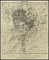
By 1930, the main mapping network was finished. This network included 105 major points and about 20,000 smaller points used for precise measurements. A detailed survey at a scale of 1:10,000 was completed in 1934. After that, a 1:2,500 property survey was done to help with land ownership records. These surveys were the basis for the larger 1:20,000 and 1:100,000 maps.
In 1940, the department stopped dealing with land ownership disputes. It focused only on making maps. In February 1940, new rules were made about selling land. Palestine was divided into three zones with different rules. These rules aimed to protect the rights of all people living there and prevent many Arabs from losing their land.
By the time the 1947–1949 Palestine war began, the Survey of Palestine had finished most of its detailed maps for the country, except for the southern Negev desert. However, they had only officially confirmed land ownership for less than 20% of the country. This was mainly in areas where Jewish settlements were located.
Growth of the Department
The mapping department grew a lot during the British Mandate. In 1921, it had 46 professionals, with 25 from outside Palestine. By 1942, it had 215 professionals, and only 11 of them were from outside Palestine. This shows that more local people were trained.
The Survey of Palestine printed many maps. They printed 1,800 maps in 1926, 19,000 in 1929, 64,000 in 1933, and 100,000 in 1939. Two schools were set up to train Palestinian and Arab surveyors. One was in Jenin (1942) and another in Nazareth (1944).
In early 1948, as the British Mandate ended, temporary leaders were chosen for the mapping departments in the proposed "Jewish State" and "Arab State." The existing maps and files were supposed to be shared. However, during the 1948 Arab–Israeli War, British trucks carrying maps meant for the "Arab state" were redirected to Tel Aviv. Today, these old maps are kept in places like the Survey of Israel and the Hebrew University of Jerusalem.
Understanding Land Ownership
In 1937, Lieutenant Colonel F. J. Salmon, who was in charge of Lands and Surveys, explained why their work was so important for buying land.
He said that in the past, land ownership papers in Palestine were often unclear. They didn't have accurate maps showing the shape, size, or exact location of the land. Descriptions were often confusing, and the reported size of the land was often wrong to avoid taxes. Large areas of land were shared by many owners without clear borders. This made buying land very risky.
The Survey Department helped solve this problem, though slowly, by settling land claims. They recorded and checked claims, and British officers helped settle disputes. Even in areas not yet fully surveyed, landowners could ask for their property to be officially registered with a modern map. This made land ownership much clearer and safer.
Important Maps and Publications
The Survey of Palestine created many different types of maps. Here are some of the most important ones:
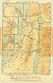
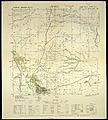
- 1:100,000 Topographical Maps: These maps showed the land's features, like hills and valleys. By 1938, they had completed maps as far south as Beersheba. You can see them here.
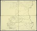
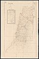
- 1:250,000 Administrative Maps: These maps showed different administrative areas. They were often used as a base for other maps that showed specific themes. You can see them here.
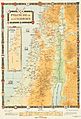
- "Palestine Index to Villages & Settlements": This was a map that showed all the villages and settlements without showing the land's features. It was usually on a single sheet. You can see it here.
- 1:500,000 Motor Map: This map was designed for drivers. You can see it here.
- 1:20,000 Topographical-Cadastral Maps: These maps were very detailed, showing both land features and property boundaries. By 1940, 45 of these maps were published, mostly for the coastal area. By 1948, about 150 sheets covered the whole country north of Beersheba. You can see them here.
- Jerusalem Maps (1:10,000 and 1:2,500): In 1936, a very detailed map of the Old City of Jerusalem was published. This was the first detailed map since 1865. Smaller scale maps of Jerusalem and its surroundings were also made. You can see them here.
- Historic Maps: The department also made maps showing Palestine in different historical periods, like "Map of Roman Palestine" (1936), "Palestine of the Crusades" (1937), and "Palestine of the Old Testament" (1939).
-
1933 Motor map of Palestine, 1:500,000
-
Palestine of the Crusades, 1:350,000
-
1928 map of Jericho region, 1:20,000
-
1942 map of Jericho region, 1:20,000
-
1937 map of Jerusalem, 1:10,000
-
Map showing all village boundaries


Rules for Surveying
The British Mandate government created laws to control surveying, surveyors, and the fees for their work.
- Cadastral Survey Ordinance 1920: This law, first for Gaza and Beersheba, then for the whole country, set rules for land surveys that show property boundaries.
- Land Surveyors Ordinance 1925: This law said that all land property records had to be based on an approved map. It also set standards for all survey maps.
- Land Settlement Ordinance 1928: This law introduced a system called the Torrens system. This system makes land ownership registration very clear and secure.
- Survey Ordinance, Surveyors Regulations 1930 and 1938: These rules set specific measurement scales for maps, like 1:10,000 for general areas and 1:2,500 or larger for individual properties. These rules were updated in 1938 and stayed in use until 1965.
Leaders of the Survey Department
Here are the people who led the Survey of Palestine department:
- June – Dec.1920: Major Cecil Verdon Quinlan
- 1920–1931/2: Major Cuthbert Hilliard Ley
- 1931–1933: Robert Barker Crusher (acting leader)
- 1933–1938: Lieutenant Colonel Frederick John Salmon (called "Commissioner of Lands and Surveys")
- 1938–1939: James Nelson Stubbs (acting leader)
- 1940–1948: Andrew Park Mitchell
Where the Headquarters Were Located

The first main office was in Gaza City in early 1920. A few months later, it moved to Jaffa. On January 1, 1931, a special building was opened for the department. It was located near the German Templar colony on the edge of Tel Aviv. This location was chosen because it was in an area favored for Jewish settlement. Some people felt that having the main office there, instead of in Jerusalem like other government offices, showed a strong connection between the land survey and Zionist goals. Ideas to move the office to Jerusalem came up in 1925, 1928, and 1935, but the office stayed in Tel Aviv.
Jerusalem Maps from 1945
| 1:10,000 | 1:5,000 | 1:2,500 | ||||||
|---|---|---|---|---|---|---|---|---|
| A | B | A | B | |||||
 |
 |
1 |  |
 |
1 |  |
||
 |
 |
2 |  |
 |
2 | |||
 |
 |
3 | ||||||
| Each sheet is a separate clickable image. | ||||||||
Earliest 1:20,000 Maps Available
| 7 | 8 | 9 | 10 | 11 | 12 | 13 | 14 | 15 | 16 | 17 | 18 | 19 | 20 | 21 |  |
|
|---|---|---|---|---|---|---|---|---|---|---|---|---|---|---|---|---|
| 29 | ||||||||||||||||
| 28 | ||||||||||||||||
| 27 | ||||||||||||||||
| 26 | ||||||||||||||||
| 25 | ||||||||||||||||
| 24 | ||||||||||||||||
| 23 | ||||||||||||||||
| 22 | ||||||||||||||||
| 21 | ||||||||||||||||
| 20 | ||||||||||||||||
| 19 | ||||||||||||||||
| 18 | ||||||||||||||||
| 17 | ||||||||||||||||
| 16 | ||||||||||||||||
| 15 | ||||||||||||||||
| 14 | ||||||||||||||||
| 13 | ||||||||||||||||
| 12 | ||||||||||||||||
| 11 | ||||||||||||||||
| 10 | ||||||||||||||||
| 9 | ||||||||||||||||
| 8 | ||||||||||||||||
| 7 |
See also
- Cartography of Palestine
- Cartography of Jerusalem
