Sutton Bank facts for kids
Quick facts for kids Sutton Bank |
|
|---|---|

A170 road climbing up Sutton Bank in North Yorkshire
|
|
| Highest point | |
| Elevation | 978 ft (298 m) |
| Listing | (none) |
| Geography | |
| Location | North York Moors National Park, England |
| Parent range | Hambleton Hills |
| OS grid | SE515815 |
| Topo map | OS Explorer OL26 |
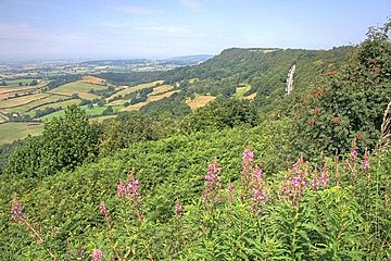
Sutton Bank is a famous hill located in the North York Moors National Park in North Yorkshire, England. It is a very high point in the Hambleton Hills, offering amazing views across the Vale of York and the Vale of Mowbray.
At the bottom of Sutton Bank is a village called Sutton-under-Whitestonecliffe. This village has one of the longest hyphenated place names in England, with 27 letters!
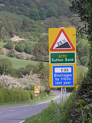
The A170 road travels down Sutton Bank. This road is very steep, with a maximum slope of 1 in 4 (25%). It also has a sharp hairpin bend. Because it's so steep, vehicles must use a low gear when going up or down. Caravans are not allowed on this part of the road for safety reasons.
Contents
What is the History of Sutton Bank?
Just south of Sutton Bank is a place called Roulston Scar. This area is home to a very important ancient monument: a huge hillfort built around 400 BC during the Iron Age.
Sutton Bank was also part of a big event in 2016. It was included in the route for the third stage of the 2016 Tour de Yorkshire cycle race, a famous bike competition.
Fun Activities at Sutton Bank
Sutton Bank is a great place for many outdoor activities.
Gliding and Flying
Because of the strong westerly winds, Sutton Bank has been used for the sport of gliding since the 1930s. Gliding involves flying in a special aircraft without an engine, using air currents. The Yorkshire Gliding Club is located at the top of the hill.
National Park Centre
Also at the top of Sutton Bank, you'll find the Sutton Bank National Park Centre. Here, you can visit the "Lime & Ice" exhibition. This cool exhibit explains how the amazing landscape and views around Sutton Bank were formed by huge ice age glaciers.
The centre also has a tourist information desk, a tea room for snacks, and a gift shop. Outside, there's a car park and easy-to-use paths for pushchairs and wheelchairs. These paths lead to a viewing platform where you can see Roulston Scar, Hood Hill, and Gormire Lake. There are many old stories about Gormire Lake, including one that says a village is hidden beneath its waters!
Walking Trails
There are many walking trails near Sutton Bank. You can walk south to see the famous White Horse of Kilburn, a large horse carved into the hillside. The Cleveland Way National Trail, which is about 110 miles (177 km) long, crosses over Sutton Bank. It even has a path that leads directly to the White Horse of Kilburn.
Cycling Adventures
The North York Moors National Park Authority has created new cycle trails at Sutton Bank. These trails mix natural paths with specially built ones, like those you'd find at a bike park. They use clear signs to help you find your way.
There are different mountain biking trails for various skill levels:
- Cliff Trail: This is a 3-mile (4.8 km) green trail, mostly flat and circular. It's perfect for families and follows part of the famous cliff edge. It opened in late 2013.
- Fort Trail: This is a 9-mile (14.5 km) blue trail with 361 meters (1,184 feet) of climbing and descending. About 70% of it is stone, and 30% is natural ground. It goes past the old Iron Age fort at Boltby Scar. There's also a shorter 6-mile (9.7 km) loop that avoids the big climbs, which is good for families. The Fort Trail also includes part of the Cliff Trail along the cliff edge.
- Paradise Trail: This is a 17-mile (27.4 km) 'red' trail. It uses existing bridleways that have been improved, but remember that walkers and horse riders also use these paths.
Sutton Bank also has a special area for practicing bike skills and a new cycle centre called Sutton Bank Bikes. Here, you can rent bikes, take training and skills courses, wash your bike, get repairs, and buy cycling gear.
Stargazing
Sutton Bank is an official Dark Sky Discovery Site. This means it's a great place to see stars and planets because there's very little light pollution. It's one of only two such sites in the North York Moors.
 | Chris Smalls |
 | Fred Hampton |
 | Ralph Abernathy |


