Swalls, Indiana facts for kids
Quick facts for kids
Swalls, Indiana
|
|
|---|---|

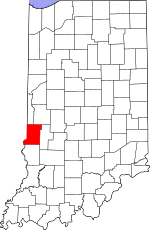
Vigo County's location in Indiana
|
|
| Country | United States |
| State | Indiana |
| County | Vigo County |
| Township | Lost Creek |
| Elevation | 594 ft (181 m) |
| Time zone | UTC-5 (Eastern (EST)) |
| • Summer (DST) | UTC-4 (EDT) |
| ZIP code |
47803
|
| Area code(s) | 812, 930 |
| GNIS feature ID | 444453 |
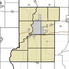
Swalls is a small place in Indiana, a state in the United States. It's not a big city or town with its own government, but rather an unincorporated community. This means it's a group of homes and buildings that are part of a larger area called Lost Creek Township in Vigo County.
Swalls is also considered part of the Terre Haute metropolitan area, which is a larger group of towns and cities around Terre Haute. One notable spot in Swalls is the Swalls Cemetery.
History of Swalls
Swalls has a short but interesting history. In 1891, a post office was opened here. A post office is a place where people can send and receive letters and packages. It was an important part of the community, helping people connect with others far away.
However, the post office in Swalls did not stay open for very long. It closed down in 1900, just nine years after it first opened. This shows how communities can change over time.
Where is Swalls Located?
Swalls is found at specific coordinates on a map: 39 degrees, 27 minutes, 37 seconds North latitude and 87 degrees, 17 minutes, 20 seconds West longitude. These numbers help pinpoint its exact spot on Earth.
The community is located at an elevation of 594 feet (about 181 meters) above sea level. This means it's about 594 feet higher than the surface of the ocean.
 | Bessie Coleman |
 | Spann Watson |
 | Jill E. Brown |
 | Sherman W. White |


