Swanbourne, Western Australia facts for kids
Quick facts for kids SwanbournePerth, Western Australia |
|||||||||||||||
|---|---|---|---|---|---|---|---|---|---|---|---|---|---|---|---|

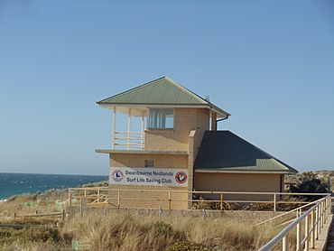
Swanbourne Nedlands Surf Life Saving Club building
|
|||||||||||||||
| Established | 1892 | ||||||||||||||
| Postcode(s) | 6010 | ||||||||||||||
| Area | 3.6 km2 (1.4 sq mi) | ||||||||||||||
| Location | 11 km (7 mi) W of the Perth CBD | ||||||||||||||
| LGA(s) | City of Nedlands | ||||||||||||||
| State electorate(s) | Cottesloe | ||||||||||||||
| Federal Division(s) | Curtin | ||||||||||||||
|
|||||||||||||||
Swanbourne is a cool coastal suburb in Perth, Western Australia. It's located right by the ocean and is known for its beautiful homes. Many of these homes are older, in a style called Federation architecture, and have been updated.
Swanbourne started as a community in the late 1800s. Recently, some new homes have been built where old schools and a drive-in cinema used to be.
Contents
A Look Back: Swanbourne's History
Did you know Swanbourne wasn't always called Swanbourne? It was first named "Osborne." But in 1921, its name was changed. This happened because people kept confusing it with another Perth suburb called Osborne Park. Imagine an ambulance going to the wrong place! To avoid mix-ups like that, the name was officially changed.
The name "Swanbourne" comes from Swanbourne House. This was a large family home in a place called Swanbourne, in England. It belonged to a famous politician named Sir Thomas Fremantle. His brother, Sir Charles Fremantle, is actually who the city of Fremantle was named after!
Where is Swanbourne? And Who Lives There?
Swanbourne is bordered by some interesting places. To the north, you'll find the Swanbourne Rifle Range and the Cottesloe Golf Club. To the east, there's Lake Claremont. The Fremantle railway line and North Street are to the south. And to the west? The amazing Indian Ocean!
People and Community
In 2016, about 4,059 people lived in Swanbourne. Most people, about 69.6%, were born in Australia. The next biggest group, 7.5%, came from England. Almost everyone, 87.0%, spoke only English at home.
Swanbourne is known as a suburb where people earn good incomes. A cool fact is that about 8.8% of the working residents in Swanbourne work in defence. This is because the Australian Army has a base here!
Swanbourne's Weather
Swanbourne has a warm, sunny climate, much like the rest of Perth. It's called a Mediterranean climate. This means it has hot, dry summers and mild, wet winters.
Because it's right by the ocean, Swanbourne often feels a bit cooler and more humid in summer than places further inland. This is thanks to the strong afternoon sea breezes. These breezes can be quite strong, helping to cool things down.
| Climate data for Swanbourne | |||||||||||||
|---|---|---|---|---|---|---|---|---|---|---|---|---|---|
| Month | Jan | Feb | Mar | Apr | May | Jun | Jul | Aug | Sep | Oct | Nov | Dec | Year |
| Record high °C (°F) | 44.3 (111.7) |
43.0 (109.4) |
42.8 (109.0) |
37.3 (99.1) |
31.5 (88.7) |
26.2 (79.2) |
25.9 (78.6) |
30.2 (86.4) |
34.2 (93.6) |
37.1 (98.8) |
41.1 (106.0) |
43.0 (109.4) |
44.3 (111.7) |
| Mean maximum °C (°F) | 39.5 (103.1) |
39.6 (103.3) |
38.2 (100.8) |
33.2 (91.8) |
27.9 (82.2) |
23.9 (75.0) |
22.5 (72.5) |
23.7 (74.7) |
26.5 (79.7) |
31.8 (89.2) |
35.8 (96.4) |
38.3 (100.9) |
41.2 (106.2) |
| Mean daily maximum °C (°F) | 29.7 (85.5) |
30.4 (86.7) |
28.8 (83.8) |
25.3 (77.5) |
22.2 (72.0) |
19.5 (67.1) |
18.4 (65.1) |
18.9 (66.0) |
19.9 (67.8) |
22.3 (72.1) |
25.4 (77.7) |
27.9 (82.2) |
24.1 (75.4) |
| Mean daily minimum °C (°F) | 18.2 (64.8) |
18.7 (65.7) |
17.5 (63.5) |
15.3 (59.5) |
12.5 (54.5) |
10.7 (51.3) |
9.7 (49.5) |
10.1 (50.2) |
11.0 (51.8) |
12.5 (54.5) |
14.8 (58.6) |
16.6 (61.9) |
14.0 (57.2) |
| Mean minimum °C (°F) | 12.8 (55.0) |
13.4 (56.1) |
11.4 (52.5) |
9.8 (49.6) |
7.2 (45.0) |
5.7 (42.3) |
4.7 (40.5) |
5.2 (41.4) |
5.9 (42.6) |
7.3 (45.1) |
9.8 (49.6) |
11.4 (52.5) |
4.0 (39.2) |
| Record low °C (°F) | 9.9 (49.8) |
11.0 (51.8) |
7.5 (45.5) |
7.5 (45.5) |
4.8 (40.6) |
2.9 (37.2) |
2.4 (36.3) |
3.1 (37.6) |
3.1 (37.6) |
5.0 (41.0) |
7.1 (44.8) |
5.7 (42.3) |
2.4 (36.3) |
| Average rainfall mm (inches) | 19.5 (0.77) |
12.1 (0.48) |
20.8 (0.82) |
38.3 (1.51) |
87.6 (3.45) |
126.2 (4.97) |
149.8 (5.90) |
119.2 (4.69) |
79.0 (3.11) |
41.9 (1.65) |
22.2 (0.87) |
11.1 (0.44) |
728.2 (28.67) |
| Average precipitation days | 2.7 | 2.1 | 3.9 | 7.4 | 11.8 | 16.6 | 18.3 | 17.3 | 15.1 | 8.9 | 5.3 | 3.5 | 112.9 |
| Average afternoon relative humidity (%) (at 15:00) | 55 | 54 | 52 | 57 | 59 | 62 | 63 | 63 | 62 | 59 | 58 | 54 | 58 |
| Source: Bureau of Meteorology Temperatures and rain data: 1993–2020; Relative humidity: 1993–2010 |
|||||||||||||
Fun Things to Do and Places to See
Swanbourne has some great facilities for sports and relaxation.
- The Cottesloe Golf Club has a big 18-hole golf course.
- Swanbourne Beach is a popular spot for swimming and relaxing.
- Allen Park is a large area with lots of sports facilities. You can find tennis courts, a field for football or cricket, and a rugby pitch there.
- Also at Allen Park is the historic Tom Collins House. Tom Collins was the pen name of Joseph Furphy, a famous Australian writer.
Important Organisations
Scotch College is a big private school for boys in Swanbourne. It's one of the largest employers in the area, after the Australian Army.
Speaking of the Army, the Australian Special Air Service Regiment (SASR) has its main base, called Campbell Barracks, right here in Swanbourne. This base is located along the coastline between Cottesloe and City Beach.
Getting Around Swanbourne
It's easy to get around Swanbourne using public transport.
Bus Services
Several bus routes run through Swanbourne, connecting it to other parts of Perth.
- Bus 27 travels from Claremont Station to East Perth. It goes along Stirling Road, Shenton Road, Servetus Street, Narla Road, and Alfred Road.
- Bus 28 goes from Claremont Station to Perth Busport. It uses Stirling Road.
- Bus 102 connects Claremont Station to Cottesloe Station. This route covers Stirling Road, Shenton Road, Servetus Street, and North Street.
Train Services
Swanbourne also has its own train station!
- The Fremantle Line train stops at Swanbourne Station. This line connects Swanbourne to Fremantle and the Perth city centre.
 | Chris Smalls |
 | Fred Hampton |
 | Ralph Abernathy |


