Tambopata River facts for kids
Quick facts for kids Tambopata River |
|
|---|---|

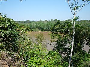
Tambopata River in the Amazon rainforest in Peru
|
|

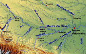
Madre de Dios watershed with the Tambopata River in the southeast (upper parts of the river not included on the map)
|
|
| Country | Bolivia, Peru |
| Physical characteristics | |
| Main source | Andes La Paz Department, Bolivia |
| River mouth | Madre de Dios River 12°35′48″S 69°10′10″W / 12.59667°S 69.16944°W |
| Length | 350 km (220 mi) |
The Tambopata River is a long river in South America. It flows through parts of southeastern Peru and northwestern Bolivia. Most of the river is in Peru, in the Madre de Dios and Puno regions. However, its very beginning is in Bolivia, in the La Paz department. For a short distance, the river even forms the border between Peru and Bolivia.
The Tambopata River is a branch of the larger Madre de Dios River. They join together near the city of Puerto Maldonado. This amazing river also flows right through the Tambopata National Reserve, a special protected area.
Contents
Exploring the Tambopata River
The Tambopata River stretches for about 350 kilometers (217 miles). It starts high up in the Andes mountains in Bolivia. From there, it winds its way down through the rainforest. The river is an important waterway for local communities and wildlife.
Where the River Flows
The Tambopata River travels through different landscapes. It begins in the mountains and then enters the flat, green Amazon rainforest. This journey makes the river important for many plants and animals. It helps connect different parts of the ecosystem.
The Tambopata National Reserve
A big part of the Tambopata River flows through the Tambopata National Reserve. This reserve is a protected area. It is home to an incredible variety of wildlife. Scientists and tourists visit to see the unique plants and animals.
Forests Along the River
The forests next to the Tambopata River are special. They are often flooded by the river's waters. The type of forest depends on how often and how long the area is underwater.
- Permanently wet forests: These are old river bends that are still flooded. They are now covered in trees.
- Seasonally wet forests: These are also old river bends. They are slowly filling up but still get flooded at certain times of the year.
- Lower floodplain forests: These are the lowest areas near the river. They get flooded often and have special trees that can handle it.
- Middle floodplain forests: These forests are a bit higher. They are tall and get flooded sometimes, but not as often as the lower areas.
- Upper floodplain forests: These are even taller forests. They are rarely flooded, only during very big floods.
- Old floodplain forests: These areas were flooded within the last 200 years. They show how the river has changed over time.
- Ancient floodplain forests: These areas were once floodplains a long time ago. Now, they are higher ground and no longer flood.
These different forest types create many homes for animals. They also show how the river shapes the land around it.
Importance of the Tambopata River
The Tambopata River is vital for the environment. It provides water for many species. It also helps transport nutrients through the rainforest. The river supports a rich ecosystem.
Wildlife and Nature
Many animals live in and around the Tambopata River. You can find monkeys, jaguars, and many types of birds. The river is also home to caimans and giant river otters. It is a true natural wonder.
Local Communities
The river is also important for people. Local communities use the river for transport. They also rely on its resources for their daily lives. Protecting the river helps both nature and people.
See also
 In Spanish: Río Tambopata para niños
 | John T. Biggers |
 | Thomas Blackshear |
 | Mark Bradford |
 | Beverly Buchanan |

