Tamborine Mountain Road facts for kids
Quick facts for kids Tamborine Mountain Road |
|
|---|---|

Tamborine Mountain Road
|
|
| Location | Geissmann Drive, North Tamborine, Scenic Rim Region, Queensland, Australia |
| Design period | 1919 - 1930s (interwar period) |
| Built | 1922 - 1925 |
| Official name: Tamborine Mountain Road/Geissmann Drive, Tamborine Station-Tamborine Mountain Road | |
| Type | state heritage (landscape, built) |
| Designated | 5 August 2003 |
| Reference no. | 602365 |
| Significant period | 1920s (fabric) |
| Significant components | embankment - road, culvert - storm water, cutting - road |
| Lua error in Module:Location_map at line 420: attempt to index field 'wikibase' (a nil value). | |
Tamborine Mountain Road is a special road in Queensland, Australia. It's located at Geissmann Drive in North Tamborine. This road was built between 1922 and 1925. It's also known as Tamborine Station-Tamborine Mountain Road and Geissmann Drive. Because it's so important, it was added to the Queensland Heritage Register on August 5, 2003.
Contents
How Tamborine Mountain Road Was Built
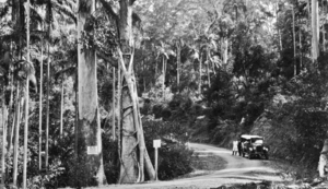
Tamborine Mountain Road was built from 1922 to 1925. Its main job was to connect the small farming town of North Tamborine to the Tamborine railway station. This connection was super important! It helped tourists visit the beautiful Tamborine Mountain. It also made it easier for farmers to sell their produce in bigger markets.
Early Challenges for Road Builders
North Tamborine sits on a high plateau, about 548 meters (1,800 feet) up. The sides of the mountain are very steep. This made it hard to build roads. Early settlers in the 1870s and 1880s made walking and horse tracks. They used these tracks to get their bananas and fruit down to Brisbane markets. But these early tracks were difficult to build and keep in good shape, especially with lots of rain.
The Geissmann Family's Role
The Tamborine Plateau became a popular spot for tourists. People loved its high elevation, rainforests, and waterfalls. In 1898, the Geissmann family moved to North Tamborine. They built a large guesthouse called Capo di Monte. It was advertised as a "Health Resort" and became very popular. Important people like the Governors of Queensland even visited! The Geissmann family was very active in the area. Later, the upper part of Tamborine Mountain Road was renamed Geissmann Drive. This was done around 1982 to honor their contributions to the community.
A New Plan for Roads
In 1918, local farmers and fruit growers wanted a better road. They asked the Tamborine Shire Council to build a good road down the mountain. This road would link North Tamborine to the railway station. By 1920, Queensland needed better roads everywhere. More cars were on the road, and the economy was growing. But local councils often didn't have enough money for good roads.
So, the Queensland Government created the Main Roads Board in 1920. This board was in charge of building important roads and bridges. They also helped local councils with money. The first chairman, JR Kemp, said old roads failed because they weren't planned well. They had steep slopes, poor drainage, and weak foundations. He set new, better standards for road design.
Funding the New Road
In 1922, a new plan called the National Main Roads Policy started. It provided money for main roads. The cost was shared: half from the Australian government, three-eighths from the state, and one-eighth from the local council. The money from the Australian government also helped give jobs to soldiers who had returned from World War I.
Tamborine Mountain Road was one of Queensland's first seven "Main Roads." This happened on December 16, 1921. The Main Roads Board gave money to the Tamborine Shire Council to build it. They also set strict rules for how the road should be built. This included how to make the road bed, culverts (water drains), and stone walls.
Building the Road
The Main Roads Board spent the most money on Tamborine Mountain Road in its first year (1922-23). The upper part of the road, from Sandy Creek to North Tamborine, was very difficult to build. It went up 548 meters (1,800 feet)! This section was finished in 1924. The rest of the road, linking Sandy Creek to the railway station, was done in 1925.
The Tamborine Shire Council then asked for the road to be covered with bitumen. This would make it last longer and cost less to maintain. It became one of the first bitumen roads in Queensland! By 1925, the total cost of the road was £42,500.
Road Tolls
Because the local council helped pay for the road, North Tamborine residents had to pay higher taxes. In 1925, their taxes were three times higher than nearby areas. This was hard for many people. So, in 1930, a new law allowed tolls on roads that cost a lot to maintain. Tamborine Mountain Road was one of the first roads in Queensland to have a toll. A toll keeper's house was even built at Sandy Creek. People hoped tolls from tourists would help pay for the road. But the toll didn't make enough money and people didn't like it. It was removed in 1945.
Tamborine Mountain Road has been the main way to get to North Tamborine for many years. It's still a very important road for tourists and locals today. Even with continuous repairs, it still has many of its original features.
What Tamborine Mountain Road Looks Like
The section of Tamborine Mountain Road from Sandy Creek to North Tamborine is about 7.7 kilometers (4.8 miles) long. It has two lanes and follows the original path. Some parts have been made wider for safety. But many original features are still there. These include culverts, cuttings, and rock walls.
Road Design Features
The road has two large "S" bends. These curves helped builders make the road go up steep hills without being too steep. Modern cars can climb steeper hills, so new roads don't usually have these kinds of bends. The original bitumen surface is still there, but it has been repaved many times over the years.
The section from Cedar Creek to North Tamborine goes through very steep hills. The road was built by cutting into the hillside. The dirt and rocks removed were used to make the road wider. Where the cliff was cut back, some rock walls were built. These walls stop the bank from falling onto the road.
Dry Stone Walls and Culverts
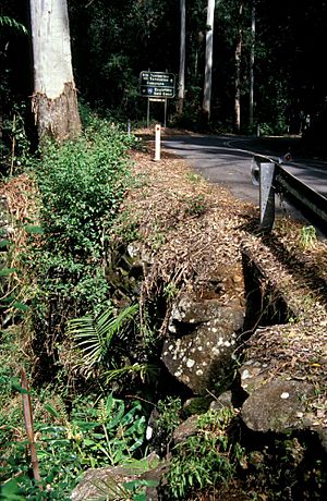
Below the road, you can see "dry stone" rock walls. These walls are built without any mortar (like cement) to hold the stones together. They cover the steep banks to stop the road from sliding downhill. To prevent heavy rain from washing the road away, there are culverts under the road. These culverts direct water away from the road surface. Some of the original culverts were not big enough for very heavy rain.
The lower part of the road, from Cedar Creek to Sandy Creek, has gentler slopes. So, there are fewer retaining walls and sharp curves here. This part of the road has been widened in some places. But it still has original culverts and walls. It passes through dry forest down to the valley.
Cuttings and Embankments
You'll find many cuttings (where the hill was cut away) and embankments (raised areas) in the upper part of the road. Many embankments are covered with dry stone walls. Some of these walls are many meters deep. You can see them from the road, but some are hidden by plants. One original stone wall is near the Sandy Creek Bridge. It's about 1.5 meters (5 feet) high and 16 meters (52 feet) long. It protects the road from floods and water runoff.
Water Drains (Culverts)
There are twelve culverts along the road. They are different ages and designs. Some are round concrete pipes, and others are larger rectangular pipes. They have rock channels and "wings" to guide water into them. Many have concrete ends to prevent erosion. Even though the road has been updated for safety, many original culverts are still working.
Roadside Scenery
The plants along the road change as you go. In the lower parts, it's a dry forest. In the upper areas, it changes to a beautiful subtropical rainforest. This rainforest, especially in Cedar Creek Valley, looks much like it did originally. It's a very important part of the road's scenery. Another interesting feature is "the Sentinel." This is a large basalt rock standing next to the upper S bend. It was too heavy to move when the road was built. Now, it's a local landmark.
Why Tamborine Mountain Road Is Important
Tamborine Mountain Road/Geissmann Drive was added to the Queensland Heritage Register on August 5, 2003. This means it's a very special place!
A Piece of History
This road is important because it was one of the first "Main Roads" in Queensland. It shows how roads were built in tough mountain areas in the 1920s. It also shows how asphalt (bitumen) was used early on. The road is a great example of how engineers started using scientific methods to build better roads. It also shows how a small community worked together to improve their access. This helped Tamborine Mountain's farming and tourism grow a lot.
Special Road Features
Tamborine Mountain Road still has many original parts from the 1920s. These include its culverts and rock walls. These features show the special rules the Main Roads Board had for building important early Queensland roads. You can see these original parts clearly in the upper third of the road.
Beautiful Scenery
The upper part of the road, called Geissmann Drive, goes through a beautiful subtropical rainforest. For many years, this section has been like a beautiful entrance to the mountain. Both locals and tourists love its beauty. Since the 1920s, most visitors have seen the mountain's amazing rainforest environment for the first time from this road. This natural beauty is highly valued.
Important to the Community
This road is important to the community because of its ongoing social and cultural connections. When the upper part of the road was renamed Geissmann Drive, the local community honored the Geissmann family. They were pioneers who owned guesthouses and sawmills. They worked hard to promote Tamborine as a health resort and tourist spot. They were active in the community for many years.
 | John T. Biggers |
 | Thomas Blackshear |
 | Mark Bradford |
 | Beverly Buchanan |


