Tatamy, Pennsylvania facts for kids
Quick facts for kids
Borough of Tatamy
|
||
|---|---|---|

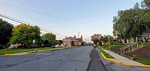
5th and Broad Streets in Tatamy, July 2021
|
||
|
||

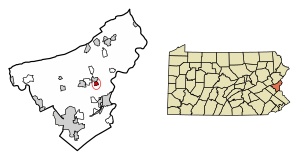
Location of Tatamy in Northampton County, Pennsylvania (left) and of Northampton County in Pennsylvania (right)
|
||
| Country | ||
| State | ||
| County | Northampton | |
| Incorporated | June 12, 1893 | |
| Settled | 1771 | |
| Named for | Moses Tunda Tatamy | |
| Area | ||
| • City | 0.57 sq mi (1.47 km2) | |
| • Land | 0.56 sq mi (1.44 km2) | |
| • Water | 0.01 sq mi (0.03 km2) | |
| Elevation | 387 ft (118 m) | |
| Population
(2020)
|
||
| • City | 1,203 | |
| • Density | 2,167.57/sq mi (837.28/km2) | |
| • Metro | 865,310 (US: 68th) | |
| Time zone | UTC-5 (EST) | |
| • Summer (DST) | UTC-4 (EDT) | |
| ZIP Code |
18085
|
|
| Area code(s) | 610 and 484 | |
| FIPS code | 42-76144 | |
| Primary airport | Lehigh Valley International Airport | |
| Major hospital | Lehigh Valley Hospital–Cedar Crest | |
| School district | Nazareth Area | |
| Website | www.tatamypa.com | |
Tatamy is a small town, called a borough, located in Northampton County, Pennsylvania. In 2020, about 1,203 people lived there. Tatamy is part of the larger Lehigh Valley area, which is home to many people.
Contents
History of Tatamy
How Tatamy Got Its Name
The borough of Tatamy is named after Moses Tunda Tatamy. He was a Native American leader. The Penn family gave him the land that would later become the town. This was a reward for his work as an interpreter. In 1745, he was the first American Indian to be baptized by David Brainerd.
Becoming a Village and Borough
In 1771, a man named Michael Messinger Sr. bought the land. He planned out a village there. By 1892, the village had grown quite a bit. It was big enough to become an official borough. Tatamy was officially made a borough on June 12, 1893. Judge H.J. Reeder made this decision.
Geography of Tatamy
Tatamy is located in Pennsylvania. The U.S. Census Bureau says the borough covers about 0.5 square miles (1.47 square kilometers). All of this area is land.
Transportation in Tatamy
As of 2021, Tatamy had about 6.59 miles of public roads. Some of these roads are kept up by the Pennsylvania Department of Transportation (PennDOT). The rest are maintained by the borough itself.
The main roads that go through Tatamy are Main Street and Eighth Street. A larger highway, Pennsylvania Route 33, passes by the west side of the borough in a nearby area called Palmer Township.
People of Tatamy
| Historical population | |||
|---|---|---|---|
| Census | Pop. | %± | |
| 1900 | 260 | — | |
| 1910 | 512 | 96.9% | |
| 1920 | 478 | −6.6% | |
| 1930 | 592 | 23.8% | |
| 1940 | 604 | 2.0% | |
| 1950 | 681 | 12.7% | |
| 1960 | 762 | 11.9% | |
| 1970 | 891 | 16.9% | |
| 1980 | 910 | 2.1% | |
| 1990 | 873 | −4.1% | |
| 2000 | 930 | 6.5% | |
| 2010 | 1,203 | 29.4% | |
| 2020 | 1,203 | 0.0% | |
| U.S. Decennial Census | |||
In 2020, the population of Tatamy was 1,203 people. The town has grown over the years. For example, in 1900, only 260 people lived there.
Public Education in Tatamy
Tatamy is part of the Nazareth Area School District. Students who live in Tatamy go to schools in this district. High school students attend Nazareth Area High School in Nazareth.
See also
 In Spanish: Tatamy para niños
 | Leon Lynch |
 | Milton P. Webster |
 | Ferdinand Smith |


