Tatitlek, Alaska facts for kids
Quick facts for kids
Tatitlek, Alaska
Taatiilaaq
|
|
|---|---|

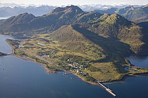
Tatitlek at the base of Ellamar Mountain
|
|

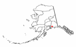
Location of Tatitlek, Alaska
|
|
| Country | United States |
| State | Alaska |
| Census Area | Chugach |
| Area | |
| • Total | 10.06 sq mi (26.06 km2) |
| • Land | 7.25 sq mi (18.78 km2) |
| • Water | 2.81 sq mi (7.28 km2) |
| Population
(2020)
|
|
| • Total | 90 |
| • Density | 12.41/sq mi (4.79/km2) |
| Time zone | UTC-9 (Alaska (AKST)) |
| • Summer (DST) | UTC-8 (AKDT) |
| ZIP code |
99677
|
| Area code(s) | 907 |
| FIPS code | 02-75380 |
Tatitlek (pronounced "tuh-TIT-lik") is a small community in Alaska, United States. It's known as a census-designated place (CDP). This means it's a special area set up by the government for counting people, but it's not an official city or town.
Tatitlek is located in the Chugach Census Area. In 2020, about 90 people lived there. The community has one school, Tatitlek Community School, which teaches around 15 students from preschool through high school. The village also has its own airport, Tatitlek Airport.
Where is Tatitlek?
Tatitlek is found in the beautiful Prince William Sound area of Alaska. Its exact location is 60 degrees 52 minutes North and 146 degrees 40 minutes West.
The total area of the community is about 18.78 square kilometers (7.25 square miles). All of this area is land.
Tatitlek is famous for being very close to where the 1989 Exxon Valdez oil spill happened. This event greatly affected the fishing in the area.
Who Lives in Tatitlek?
Tatitlek has been counted in the U.S. Census since 1880. Back then, it was called "Tatikhlek." The number of people living there has changed over the years.
| Historical population | |||
|---|---|---|---|
| Census | Pop. | %± | |
| 1880 | 73 | — | |
| 1890 | 90 | 23.3% | |
| 1900 | 149 | 65.6% | |
| 1910 | 156 | 4.7% | |
| 1920 | 187 | 19.9% | |
| 1930 | 70 | −62.6% | |
| 1940 | 75 | 7.1% | |
| 1950 | 89 | 18.7% | |
| 1960 | 96 | 7.9% | |
| 1970 | 111 | 15.6% | |
| 1980 | 68 | −38.7% | |
| 1990 | 119 | 75.0% | |
| 2000 | 107 | −10.1% | |
| 2010 | 88 | −17.8% | |
| 2020 | 90 | 2.3% | |
| U.S. Decennial Census | |||
When it first appeared in 1880, all 73 residents were listed as Inuit. However, they were actually Chugach Alutiiq people. In 1890, the name changed to "Tatitlak." At that time, it also included a nearby village.
The name became "Tatiklek" in 1900. Since 1910, it has been spelled "Tatitlek." In 1980, it officially became a census-designated place (CDP).
Inside Tatitlek's boundaries is the old mining village of Ellamar. Ellamar was also counted in some past censuses.
People and Families
In 2000, there were 107 people living in Tatitlek. These people lived in 38 households. Most of these households (28) were families.
Many households (44.7%) had children under 18 living with them. About 47.4% were married couples. Some households (21.1%) had a female head of household without a husband.
The average household had 2.82 people. The average family had 3.28 people.
Age Groups
The population of Tatitlek in 2000 had different age groups:
- 36.4% were under 18 years old.
- 7.5% were between 18 and 24 years old.
- 24.3% were between 25 and 44 years old.
- 24.3% were between 45 and 64 years old.
- 7.5% were 65 years or older.
The average age of people in Tatitlek was 30 years old.
See also
 In Spanish: Tatitlek (Alaska) para niños

