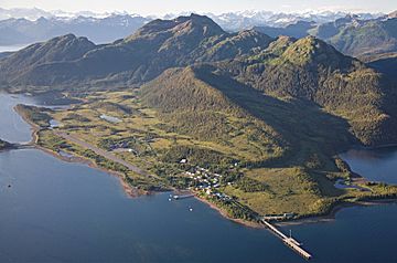
Ellamar Mountain facts for kids
Quick facts for kids Ellamar Mountain |
|
|---|---|

Ellamar Mountain, south aspect
(Tatitlek down in front) |
|
| Highest point | |
| Elevation | 3,051 ft (930 m) |
| Prominence | 2,851 ft (869 m) |
| Isolation | 4.36 mi (7.02 km) |
| Parent peak | Copper Mountain |
| Geography | |
| Location | Valdez-Cordova Borough Alaska, United States |
| Parent range | Chugach Mountains |
| Topo map | USGS Cordova D-8 |
Ellamar Mountain is a noticeable mountain in Alaska, a state in the United States. It stands about 3,051 feet (930 meters) tall. This mountain is part of the Chugach Mountains, a large mountain range.
Ellamar Mountain is located about 42 miles (68 km) northwest of Cordova. It is also 18 miles (29 km) southwest of Valdez. The small town of Tatitlek is only 3 miles (5 km) to the south. The land around the mountain is looked after by the Chugach National Forest.
The mountain is about 9 miles (14 km) northeast of Bligh Reef. This reef is famous because of the 1989 Exxon Valdez oil spill. This was a big event where oil spilled into the ocean.
The mountain got its name from a copper mining camp called "Ellamar." This camp was at the bottom of the mountain. The name "Ellamar" is a mix of two names: Ella and Margaret. C. L. Wayland, who was an early Postal Inspector for Alaska, created the name. He used the names of his wife, Ella, and his daughter, Margaret. Water from the mountain flows into Prince William Sound.
Mountain Climate
Ellamar Mountain has a subarctic climate. This means it has long, cold, and snowy winters. The summers are usually cool. Weather systems from the Gulf of Alaska bring a lot of rain and snow. This happens because the Chugach Mountains push the air upwards. This is called orographic lift.
Temperatures on the mountain can drop very low. They can go below −4 °F (−20 °C). With the wind, it can feel even colder, sometimes below −22 °F (−30 °C). The best time to visit or climb Ellamar Mountain is usually in May and June. The weather is often clearer and more pleasant then.


