
Tecpán, Guatemala facts for kids
Quick facts for kids
Tecpán
|
|
|---|---|
|
Municipality and town
|
|

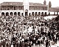
Tecpán plaza in 1893.
|
|

Tecpán, Guatemala
Location in Guatemala
|
|
| Country | |
| Department | |
| Area | |
| • Total | 102 sq mi (264 km2) |
| Population
(2018 census)
|
|
| • Total | 91,927 |
| • Density | 901.9/sq mi (348.2/km2) |
| Time zone | UTC-6 (Central Time) |
| Climate | Cwb |
| Website | www.munitecpanguatemala.gob.gt |
Tecpán is a town and a municipality in the department of Chimaltenango, Guatemala. It is located on the main highway, CA-1. In 2018, the town had about 34,519 people.
Tecpán has a cool climate. Many people visit Tecpán because of its beautiful views and different types of plants. It is also a good starting point to visit the ancient site of Iximché.
History of Tecpán

Tecpán is often called the 'first capital of Guatemala.' This is because it was the first permanent Spanish military base in the country. It was set up in 1525. The first actual government capital was Ciudad Vieja, built in 1527.
The Spanish built a fort here. They found it hard to defeat the Kaqchikel Maya people. This was during the time the Spanish took over Guatemala.
The old capital city of the Kaqchikel, Iximché, is nearby. Its ruins are on a high hill not far from Tecpán.
People of Tecpán
Tecpán is one of the larger municipalities in Guatemala. This is because it covers a wide area. Most of the people living here are indigenous. Over 90% of the population are descendants of the Kaqchikel Maya.
Climate in Tecpán
Tecpán has a subtropical highland climate. This means it has mild temperatures all year round. It's often cool, especially compared to warmer parts of Guatemala.
Images for kids
-
Tecpán plaza in 1893.
See also
 In Spanish: Tecpán Guatemala para niños
