Ciudad Vieja facts for kids
Quick facts for kids
Ciudad Vieja
|
|
|---|---|
|
Municipality and town
|
|

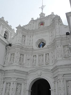
Facade of the church of Ciudad Vieja
|
|
| Country | |
| Department | Sacatepéquez |
| Area | |
| • Total | 26.9 km2 (10.4 sq mi) |
| Elevation | 1,550 m (5,090 ft) |
| Population
(2018)
|
|
| • Total | 33,405 |
| • Density | 1,241.8/km2 (3,216/sq mi) |
| Time zone | UTC-6 (Central Time) |
| Climate | Cwb |
| Criteria: | Cultural: (ii)(iii)(iv) |
| Designated: | 1979 (3rd session) |
| Part of: | Antigua Guatemala |
| Reference #: | 65-005 |
Ciudad Vieja (which means "Old City" in Spanish) is a town and a municipality in the Sacatepéquez Department of Guatemala. In 2018, about 33,405 people lived in this area.
Ciudad Vieja was once a very important place. It was the second capital city of Guatemala during the time it was a Spanish colony. The original name for the area where the old capital stood is San Miguel Escobar.
The Spanish founded their capital here in 1527. Their first capital, Tecpán Guatemala, was no longer safe. However, the city in Ciudad Vieja was destroyed in 1541. A huge mudslide, called a lahar, came down from the Volcan de Agua mountain. Many people died, including the governor, Beatriz de la Cueva. The people who survived had to leave the city.
History of Ciudad Vieja

The second capital of Guatemala was founded here in 1527 by Jorge de Alvarado. This was for the Captaincy General of Guatemala, which was a large area controlled by Spain.
Even back in 1818, historians weren't sure about the exact spot of the first settlement. Some thought the Spanish first settled temporarily in a place called Almolonga. They believed this spot later became a neighborhood in the main city. Others thought the Spanish built the city on an old native king's court.
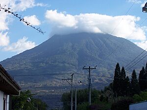
No matter the exact starting point, the city council decided on a permanent location. It was at the base of the Volcán de Agua mountain. This new city quickly became very important.
However, the city's growth stopped fourteen years later. On September 11, 1541, a terrible mudslide from Volcán de Agua destroyed it. This mudslide carried large rocks, damaging many buildings.
The city was left without a leader because Governor Beatriz de la Cueva died in the disaster. She had become governor shortly after her husband, Pedro de Alvarado, passed away. Beatriz de la Cueva was very sad. On September 9, 1541, she signed official papers as "la sin ventura," meaning "the hapless one." This phrase turned out to be sadly true.
The survivors quickly met to decide what to do. They appointed Bishop Francisco Marroquín and Francisco de la Cueva as temporary governors.
On September 27, 1541, a group went to find a new location for the capital. After two days, they suggested the Tianguecillo Valley. However, an engineer named Juan Bautista Antonelli arrived. He suggested moving the city to Panchoy Valley instead. He said this valley was safer from volcanoes and had plenty of water. He also noted it was flat and large enough for a big city.
In 1895, Anne Cary Maudslay and her husband, archeologist Alfred Percival Maudslay, visited the area. They climbed Volcán de Agua. Anne Cary Maudslay wrote a book where she explained that the volcano's crater likely didn't burst. Instead, she believed heavy rain caused a large landslide. This landslide would have caused the damage to the old city.
Ciudad Vieja in Books
The Guatemalan writer and historian José Milla y Vidaurre wrote a novel called La hija del Adelantado. This story uses historical events from the months leading up to the destruction of Ciudad Vieja.
Climate
Ciudad Vieja has a subtropical highland climate. This means it has mild temperatures all year round. It also experiences a wet season and a dry season.
| Climate data for Ciudad Vieja | |||||||||||||
|---|---|---|---|---|---|---|---|---|---|---|---|---|---|
| Month | Jan | Feb | Mar | Apr | May | Jun | Jul | Aug | Sep | Oct | Nov | Dec | Year |
| Mean daily maximum °C (°F) | 22.7 (72.9) |
23.5 (74.3) |
24.7 (76.5) |
24.9 (76.8) |
24.7 (76.5) |
23.8 (74.8) |
23.6 (74.5) |
23.9 (75.0) |
23.1 (73.6) |
22.8 (73.0) |
23.1 (73.6) |
22.4 (72.3) |
23.6 (74.5) |
| Daily mean °C (°F) | 16.8 (62.2) |
17.3 (63.1) |
18.4 (65.1) |
19.1 (66.4) |
19.5 (67.1) |
19.7 (67.5) |
19.2 (66.6) |
19.2 (66.6) |
18.8 (65.8) |
18.4 (65.1) |
18.0 (64.4) |
16.8 (62.2) |
18.4 (65.2) |
| Mean daily minimum °C (°F) | 10.8 (51.4) |
11.1 (52.0) |
11.9 (53.4) |
13.3 (55.9) |
14.3 (57.7) |
15.3 (59.5) |
14.6 (58.3) |
14.3 (57.7) |
14.4 (57.9) |
13.9 (57.0) |
12.7 (54.9) |
11.3 (52.3) |
13.2 (55.7) |
| Average precipitation mm (inches) | 2 (0.1) |
5 (0.2) |
6 (0.2) |
28 (1.1) |
125 (4.9) |
255 (10.0) |
181 (7.1) |
154 (6.1) |
255 (10.0) |
142 (5.6) |
20 (0.8) |
6 (0.2) |
1,179 (46.3) |
| Source: Climate-Data.org | |||||||||||||
Where is Ciudad Vieja?
The modern Ciudad Vieja municipality is surrounded by other towns in the Sacatepéquez Department:
 |
San Antonio Aguas Calientes and Antigua Guatemala | Antigua Guatemala |  |
|
| San Miguel Dueñas | Antigua Guatemala | |||
| Alotenango | Alotenango |
See also
 In Spanish: Ciudad Vieja (Guatemala) para niños
 | Toni Morrison |
 | Barack Obama |
 | Martin Luther King Jr. |
 | Ralph Bunche |


