Alotenango facts for kids
Quick facts for kids
Alotenango
|
|
|---|---|
|
Municipality and town
|
|

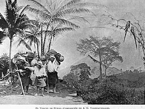
Photographic composition of Volcán de Fuego as seen from Alotenango in 1897. Composition by Alberto G. Valdeavellano.
|
|
| Country | |
| Department | |
| Area | |
| • Total | 98.7 km2 (38.1 sq mi) |
| Population
(2018 census)
|
|
| • Total | 23,986 |
| • Density | 243.02/km2 (629.4/sq mi) |
| Time zone | UTC-6 (Central Time) |
| Climate | Cwb |
Alotenango is a town and municipality in the Sacatepéquez area of Guatemala. Its name means "in the wall of the parrots." In 2018, about 23,358 people lived there. The town is located in a valley and is known for its coffee farms. It sits along National Highway 14, which connects it to other important places.
Contents
History of Alotenango

Alotenango is mentioned in the ancient Maya book called the Popol Vuh. The original settlement was a few kilometers south of where the town is today. This community existed even before the Spanish arrived in 1524.
In the 1540s, a bishop named Francisco Marroquín divided the religious areas of Guatemala's central valley. Alotenango became part of the area looked after by the Franciscans, a group of religious people. This division also helped define the borders of the valley.
Exploring the Volcanoes
In 1881, a French writer named Eugenio Dussaussay wanted to climb the nearby volcano, Volcán de Fuego, which was mostly unexplored. He got permission from the governor and found a guide from Alotenango named Rudecindo Zul. The townspeople respected the volcano a lot and were afraid to go too high. So, Rudecindo only guided them to the saddle (a low point) between Volcán de Fuego and volcán Acatenango.
Later, in 1892, an archeologist named Alfred Percival Maudslay also explored Volcán de Fuego from Alotenango. He wrote about his adventures in his book, A Glimpse at Guatemala.
Culture and Traditions
Alotenango has a Franciscan monastery and a large church. There's also a big hut that has been used as a courthouse, and a sandy town square where a Sunday market is held.
The people living in Alotenango are mostly Maya peoples. They have a special local culture that mixes old Maya society traditions with the Hispanic culture. Many residents are peasant farmers who belong to the Cakchiquel group. They used to speak only the Cakchiquel language, but now most also speak Spanish.
Some historians believe that the town's people are descendants of the Nahua-speaking Pipils, who are an indigenous group from El Salvador. However, an old legal document from the 16th century, called the Titulo de Alotenango, shows that land arguments were between the Cakchiquel people of Alotenango and the Pipil people of Escuintla.
In Alotenango, married couples often live with the husband's family until they have several children. A special festival day is held on June 24th to honor Saint John the Baptist, who is the town's patron saint.
Economy and Coffee
Alotenango is part of the famous Antigua coffee region, known for producing high-quality coffee.
The Capetillo Coffee Farm
The Capetillo farm started in the 1700s. At first, it only grew sugar cane. But in 1875, Jose Mariano Rodriguez bought the farm and began growing coffee. The farm quickly became very successful. By 1880, it had 200,000 coffee trees and was making a lot of money. Capetillo coffee even won a big award at the 1915 Universal Exhibition, which was a huge international fair.
Climate in Alotenango
Alotenango has a mild climate, which is called a temperate climate (Köppen climate classification Cwb). This means it has warm summers and mild winters.
| Climate data for Alotenango | |||||||||||||
|---|---|---|---|---|---|---|---|---|---|---|---|---|---|
| Month | Jan | Feb | Mar | Apr | May | Jun | Jul | Aug | Sep | Oct | Nov | Dec | Year |
| Mean daily maximum °C (°F) | 23.8 (74.8) |
24.6 (76.3) |
25.7 (78.3) |
26.1 (79.0) |
25.8 (78.4) |
24.8 (76.6) |
24.7 (76.5) |
24.9 (76.8) |
24.2 (75.6) |
23.9 (75.0) |
24.1 (75.4) |
23.4 (74.1) |
24.7 (76.4) |
| Daily mean °C (°F) | 18.0 (64.4) |
18.5 (65.3) |
19.4 (66.9) |
20.4 (68.7) |
20.7 (69.3) |
20.6 (69.1) |
20.1 (68.2) |
20.1 (68.2) |
19.7 (67.5) |
19.3 (66.7) |
19.0 (66.2) |
17.9 (64.2) |
19.5 (67.1) |
| Mean daily minimum °C (°F) | 12.2 (54.0) |
12.4 (54.3) |
13.2 (55.8) |
14.7 (58.5) |
15.6 (60.1) |
16.4 (61.5) |
15.6 (60.1) |
15.4 (59.7) |
15.3 (59.5) |
14.8 (58.6) |
13.9 (57.0) |
12.4 (54.3) |
14.3 (57.8) |
| Average precipitation mm (inches) | 5 (0.2) |
9 (0.4) |
16 (0.6) |
41 (1.6) |
168 (6.6) |
389 (15.3) |
275 (10.8) |
288 (11.3) |
420 (16.5) |
218 (8.6) |
35 (1.4) |
10 (0.4) |
1,874 (73.7) |
| Source: Climate-Data.org | |||||||||||||
Where is Alotenango Located?
Alotenango is a great starting point for climbing Volcán de Agua, which is a large volcano located to the east of the town. You can also start climbing Volcán de Fuego from Alotenango. National Highway 14 connects Alotenango to the cities of Antigua Guatemala in the north and Escuintla in the south.
 |
San Miguel Dueñas and Ciudad Vieja, Sacatepéquez Department | Ciudad Vieja, Sacatepéquez Department |  |
|
| Yepocapa, Chimaltenango Department municipality Escuintla, Escuintla Department municipality |
Escuintla, Escuintla Department municipality | |||
| Escuintla, Escuintla Department municipality |
See also
 In Spanish: Alotenango para niños
 | Ernest Everett Just |
 | Mary Jackson |
 | Emmett Chappelle |
 | Marie Maynard Daly |


