Yepocapa facts for kids
Quick facts for kids
San Pedro Yepocapa
Apocapa
Yepocapa
|
|
|---|---|
|
Municipality and town of Guatemala
|
|
| Country | |
| Department | |
| Government | |
| • Type | Municipal |
| Area | |
| • Total | 83 sq mi (214 km2) |
| Elevation | 4,600 ft (1,400 m) |
| Population
(2018 census)
|
|
| • Total | 34,948 |
| • Density | 423.0/sq mi (163.3/km2) |
| Time zone | UTC+6 (Central Time) |
| Climate | Am |
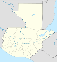
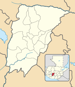
Yepocapa, also known as San Pedro Yepocapa, is a town and a municipality in Guatemala. It is located in the Chimaltenango department. In 2018, about 17,021 people lived in the town.
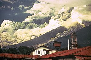
Yepocapa is at the base of a volcano called Volcán de Fuego. This volcano has erupted many times. It has even destroyed the town more than once. The most recent big eruption happened on October 15, 1974.
Contents
History of Yepocapa
San Pedro Yepocapa has a long history. It existed even before the Spanish arrived. The town was first built very close to Volcán de Fuego. But because of many eruptions, people had to move it to a safer spot. A Spanish soldier named Antonio de Guzmán is said to have found the town in the 1520s.
Spanish Rule and Franciscan Friars
After the Spanish took control, a group of religious people called Franciscans looked after the town. They had churches and taught people in many areas of Guatemala. By the year 1700, the Franciscans had set up 24 religious centers.
The Franciscans taught religion to children every day. Girls and boys aged six and older learned about the church. They memorized prayers and studied a book called the catechism. Older local people or priests led these classes. Adults went to church every Sunday and on special holidays. After church, they also had religious lessons in their own language.
During a special time called Lent, the friars taught the local people even more. They used the people's own language to help them understand. Every Friday during Lent, there was a procession. People walked together, following the steps of the Rosary, all the way to a special temple.
A document from 1686 describes the Franciscan centers. It says that San Pedro Yepocapa was about 16 kilometers from a main center. It was on a road leading to the coast. The document also noted that the town had a warm climate. In 1754, the Franciscans had to give up their teaching duties to other church leaders. This was part of changes made by the Spanish government.
After Guatemala Became Independent
Guatemala became independent from Spain. On October 11, 1825, San Pedro Yepocapa was officially made a town. Later, on September 12, 1839, it became a municipality. This meant it could govern itself more. By 1880, over a thousand people lived there. Most people worked in farming.
The 1974 Volcán de Fuego Eruption

On October 15, 1974, the Volcán de Fuego erupted. Around 2:00 AM, tremors woke people up in nearby towns. Then, ash and cinders started falling from the sky. The town was covered in darkness for several days. The president of Guatemala, Kjell Eugenio Laugerud García, ordered people to leave. Many were sad to lose their homes and things. The ash traveled very far, even reaching parts of Mexico.
San Pedro Yepocapa was one of the towns hit hardest. After four days of eruption, it was covered in over a meter of ash. About 1,100 people from nearby areas had to move. They went to temporary shelters in towns like Santa Lucía Cotzumalguapa or Patulul.
Local leaders asked other towns for help. They wanted support for San Pedro Yepocapa and Acatenango. These towns were almost destroyed by the disaster. Help started to arrive on October 24, 1974, when the eruption stopped. Road crews came to clean up the towns. This cleanup work took three months.
Climate
San Pedro Yepocapa has a tropical monsoon climate. This means it has a warm climate with a lot of rain during certain months.
| Climate data for Acatenango | |||||||||||||
|---|---|---|---|---|---|---|---|---|---|---|---|---|---|
| Month | Jan | Feb | Mar | Apr | May | Jun | Jul | Aug | Sep | Oct | Nov | Dec | Year |
| Mean daily maximum °C (°F) | 25.5 (77.9) |
25.9 (78.6) |
26.8 (80.2) |
26.7 (80.1) |
26.4 (79.5) |
25.3 (77.5) |
25.6 (78.1) |
25.7 (78.3) |
25.0 (77.0) |
24.8 (76.6) |
25.3 (77.5) |
25.0 (77.0) |
25.7 (78.2) |
| Daily mean °C (°F) | 19.5 (67.1) |
19.7 (67.5) |
20.6 (69.1) |
21.0 (69.8) |
21.2 (70.2) |
21.0 (69.8) |
20.9 (69.6) |
20.8 (69.4) |
20.3 (68.5) |
20.0 (68.0) |
19.9 (67.8) |
19.2 (66.6) |
20.3 (68.6) |
| Mean daily minimum °C (°F) | 13.5 (56.3) |
13.6 (56.5) |
14.4 (57.9) |
15.4 (59.7) |
16.0 (60.8) |
16.7 (62.1) |
16.2 (61.2) |
16.0 (60.8) |
15.7 (60.3) |
15.3 (59.5) |
14.6 (58.3) |
13.5 (56.3) |
15.1 (59.1) |
| Average precipitation mm (inches) | 8 (0.3) |
18 (0.7) |
29 (1.1) |
65 (2.6) |
209 (8.2) |
494 (19.4) |
324 (12.8) |
345 (13.6) |
534 (21.0) |
302 (11.9) |
60 (2.4) |
13 (0.5) |
2,401 (94.5) |
| Source: Climate-Data.org | |||||||||||||
Geographic Location
 |
Pochuta, Chimaltenango | Acatenango, Chimaltenango Department |  |
|
| Patulul, Suchitepéquez Department municipality | Alotenango, Sacatepéquez. | |||
| Santa Lucía Cotzumalguapa, Escuintla Department municipality |
See also
 In Spanish: Yepocapa para niños
 | May Edward Chinn |
 | Rebecca Cole |
 | Alexa Canady |
 | Dorothy Lavinia Brown |


