Acatenango, Chimaltenango facts for kids
Quick facts for kids
Acatenango
|
|
|---|---|
|
Municipality and town
|
|
| Country | |
| Department | |
| Area | |
| • Municipality and town | 55 sq mi (143 km2) |
| Population
(2018 census)
|
|
| • Municipality and town | 23,228 |
| • Density | 420.7/sq mi (162.4/km2) |
| • Urban | 12,136 |
| Time zone | UTC+6 (Central Time) |
| Climate | Cwb |
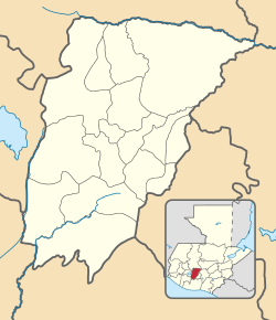
Acatenango is a town and municipality in the Chimaltenango department of Guatemala. It is famous because the Acatenango volcano is located here. The town sits in the beautiful valley of the Cocoyá River.
Contents
History of Acatenango
Life During the Spanish Colony
During the time of the Spanish colony, the Catholic faith in Acatenango was managed by a group of priests called the Franciscans. They had special areas called "doctrines" where they taught people. These areas covered many modern departments in Guatemala.
The Franciscans had 24 convents, which are like monasteries. In 1700, a convent in Panajachel had three priests. They were in charge of about 1800 people and many "cofradías." Cofradías were religious groups or brotherhoods.
In Acatenango, there was a convent, so people could attend daily Mass. Leaders of the cofradías and their wives would keep candles lit during the service. The Franciscans also tried to teach religion every day. Girls and boys aged six and older had classes for two hours. They learned prayers and church teachings. Sometimes, older local people called "fiscales" helped with the teaching.
On Sundays and holidays, adults went to Mass. After Mass, they received religious lessons in their own language. During Lent, the friars worked hard to prepare the local people. They used the local language to help them understand. Every Friday during Lent, there was a procession that followed the steps of the Rosary.
In 1754, the Franciscans had to give up their teaching areas. This was part of big changes made by the Spanish king, known as the Bourbon Reforms.
After Guatemala Became Independent
Guatemala became independent from Spain. On October 11, 1825, the State of Guatemala was created. Acatenango was officially recognized as a town. Later, on September 12, 1839, it became a municipality within the Chimaltenango District.
The 1974 Volcán de Fuego Eruption

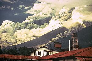
On October 15, 1974, the Volcán de Fuego erupted. Tremors woke up people in nearby towns at 2:00 AM. Then, rumbling sounds started, and cinders and ashes began to fall. The town was covered in darkness for several days.
The President, Kjell Eugenio Laugerud García, ordered people to leave their homes. Many people were sad to lose their belongings because of the eruption. The ash traveled very far, even reaching parts of Mexico. Mexican authorities were on alert due to the large amount of ash.
San Pedro Yepocapa was one of the towns hit hardest. It ended up under more than one meter of ash after the eruption, which lasted four days. About 1100 people from a place called Morelia and nearby areas had to move. They went to temporary shelters in towns like Santa Lucía Cotzumalguapa or Patulul.
The directors of the Democracia Cristiana Guatemalteca (DCG) party asked all mayors for help. They wanted help for their colleagues in San Pedro Yepocapa and Acatenango. These towns were almost destroyed by the disaster. Both mayors belonged to the DCG party. Help started to arrive on October 24, 1974, when the eruption stopped. Equipment from Guatemala's Road General Direction came to clean up the towns. This cleanup operation took three months.
Acatenango Volcano
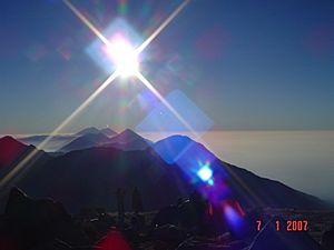
The Acatenango volcano is a huge mountain. It stands more than 3,500 meters (about 11,500 feet) above the Pacific coast to the south. It is also 2,000 meters (about 6,500 feet) above the Guatemalan Highlands to the north. This volcano is actually made up of parts from many past eruptions. Over time, these parts have collapsed, creating huge landslides.
The biggest of these landslides traveled more than 50 kilometers (about 31 miles). It covered over 300 square kilometers (about 116 square miles). Unlike its neighbor, Volcán de Fuego, Acatenango volcano has been quiet for the last six hundred years. This means it has not erupted in a very long time.
Town and Municipality Areas
Urban Areas
The main town area of Acatenango is divided into three zones:
- Zone 1: This zone includes the neighborhoods of San Carlos, El Potrerito, and Naranjales.
- Zone 2: This zone covers the urban parts of Calle Real, La Ladrillera, El Calvario, and Los Olivos.
- Zone 3: This zone has the neighborhoods of El Sare and El Campo. It also includes the urban parts of El Caracol, El Cementerio, El Parque, and Las Lajas.
- The El Tanque urban area is located between Zone 2 and Zone 3.
Municipality Divisions
| Type of Settlement | Names |
|---|---|
| Villages | El Destierro (La Soledad), San Antonio Nejapa, Los Planes, El Socorro, Los Pajales I, Los Pajales II, Quisajche, Nueva Concepción, El Campamento, La Pampa, Pacoc, Pacacay, Pueblo Nuevo and Santa Isabel. |
| Settlements | Xacaya, Ana Chimichabal, El Tesoro, El Mirador and Tzinquinya. |
| Rural regions | Los Cerritos and Agua Caliente. |
Climate
Acatenango has a subtropical highland climate. This type of climate is often found in high-altitude areas in the tropics. It means the weather is generally mild, not too hot or too cold.
| Climate data for Acatenango | |||||||||||||
|---|---|---|---|---|---|---|---|---|---|---|---|---|---|
| Month | Jan | Feb | Mar | Apr | May | Jun | Jul | Aug | Sep | Oct | Nov | Dec | Year |
| Mean daily maximum °C (°F) | 23.9 (75.0) |
24.5 (76.1) |
25.5 (77.9) |
25.5 (77.9) |
25.2 (77.4) |
23.9 (75.0) |
24.3 (75.7) |
24.3 (75.7) |
23.5 (74.3) |
23.3 (73.9) |
23.9 (75.0) |
23.5 (74.3) |
24.3 (75.7) |
| Daily mean °C (°F) | 17.6 (63.7) |
18.0 (64.4) |
18.9 (66.0) |
19.6 (67.3) |
19.8 (67.6) |
19.6 (67.3) |
19.5 (67.1) |
19.2 (66.6) |
18.8 (65.8) |
18.4 (65.1) |
18.4 (65.1) |
17.4 (63.3) |
18.8 (65.8) |
| Mean daily minimum °C (°F) | 11.4 (52.5) |
11.6 (52.9) |
12.4 (54.3) |
13.7 (56.7) |
14.4 (57.9) |
15.3 (59.5) |
14.7 (58.5) |
14.2 (57.6) |
14.2 (57.6) |
13.6 (56.5) |
12.9 (55.2) |
11.4 (52.5) |
13.3 (56.0) |
| Average precipitation mm (inches) | 4 (0.2) |
12 (0.5) |
13 (0.5) |
45 (1.8) |
146 (5.7) |
370 (14.6) |
233 (9.2) |
235 (9.3) |
383 (15.1) |
208 (8.2) |
41 (1.6) |
9 (0.4) |
1,699 (67.1) |
| Source: Climate-Data.org | |||||||||||||
Where Acatenango is Located
 |
Patzicía, Zaragoza and Patzún, municipalities of Chimaltenango Department | San Andrés Itzapa, municipality of Chimaltenango Department |  |
|
| Pochuta, municipality of Chimaltenango Department | San Miguel Dueñas, municipality of Sacatepéquez Department | |||
| San Pedro Yepocapa, municipality of Chimaltenango Department |
See also
 In Spanish: Acatenango (Guatemala) para niños
 | Janet Taylor Pickett |
 | Synthia Saint James |
 | Howardena Pindell |
 | Faith Ringgold |


