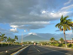
Escuintla facts for kids
Quick facts for kids
Escuintla
|
|||
|---|---|---|---|
|
Municipality
|
|||

Escuintla, Guatemala
|
|||
|
|||
| Country | |||
| Department | |||
| Municipality | Escuintla | ||
| Government | |||
| • Type | Municipal | ||
| Area | |||
| • Municipality | 545 km2 (210 sq mi) | ||
| Elevation | 355 m (1,165 ft) | ||
| Population
(census 2018)
|
|||
| • Municipality | 156,313 | ||
| • Density | 286.81/km2 (742.8/sq mi) | ||
| • Urban | 156,313 | ||
| • Religions | Roman Catholicism Evangelicalism | ||
| Climate | Am | ||
Escuintla (pronounced es-KWEENT-lah) is an important city in Guatemala. It's known for its many factories and for growing a lot of sugar cane. The city is also the capital of the Escuintla Department. People in Escuintla celebrate a special fair from December 6 to 9.
In 2018, about 156,313 people lived in Escuintla. The city is located where the central highlands meet the Pacific coast.
Contents
What Does Escuintla Mean?
Many towns in Guatemala have names that come from two main sources. Some are named after Catholic saints. Others have names with roots in the Nahuatl language. This is because when Pedro de Alvarado and his Spanish soldiers invaded the area in the 1520s, they had indigenous Tlaxcaltec allies who spoke Nahuatl.
The name Escuintla comes from the Nahuatl words:
- «Itzcuintli»: This word means "dog."
- «tlan»: This word means "abundance" or "place of."
So, Escuintla means "abundance of dogs" or "place of dogs."
A Look at Escuintla's Past
Escuintla used to be a very important stop for trains. These trains traveled to Puerto San José, a port city. However, the train service stopped in 2007.
How Escuintla Makes Money
Escuintla is one of the most industrial areas in Guatemala. This means it has many factories and businesses. A very important farm product grown here is sugar cane. Other key products include tobacco, seafood, and cattle.
The region of Escuintla, which touches the Pacific Ocean, produces about 43 percent of Guatemala's total economic output. It has very low unemployment and extreme poverty compared to other parts of Guatemala.
Nature and Location
The city of Escuintla includes two villages and 12 smaller communities nearby. The area has seven mountains, 55 rivers, nine streams, and 21 brooks.
Where is Escuintla Located?
Escuintla is surrounded by several other towns and areas.
- To the north, you'll find Yepocapa (in the Chimaltenango Department) and Alotenango (in the Sacatepéquez Department).
- To the east are Palin, San Vicente Pacaya, and Guanagazapa (all in the Escuintla Department).
- To the south is Masagua (also in the Escuintla Department).
- To the west are La Democracia, Siquinalá, and Santa Lucía Cotzumalguapa (all in the Escuintla Department).
Getting Around Escuintla
Today, two major highways, CA-2 and CA-9, pass through Escuintla. These roads help people and goods travel easily.
Sports in Escuintla
The local football (soccer) team is called Juventud Escuintleca. They play their home games at the Estadio Ricardo Muñoz Gálvez. The team currently plays in the second division of Guatemalan football.
Escuintla's Weather
Escuintla has a tropical monsoon climate. This means it has warm temperatures all year round and a lot of rain during certain months.
| Climate data for Escuintla | |||||||||||||
|---|---|---|---|---|---|---|---|---|---|---|---|---|---|
| Month | Jan | Feb | Mar | Apr | May | Jun | Jul | Aug | Sep | Oct | Nov | Dec | Year |
| Mean daily maximum °C (°F) | 31.9 (89.4) |
32.1 (89.8) |
33.4 (92.1) |
33.3 (91.9) |
32.5 (90.5) |
31.2 (88.2) |
31.5 (88.7) |
31.2 (88.2) |
30.2 (86.4) |
30.1 (86.2) |
30.4 (86.7) |
31.0 (87.8) |
31.6 (88.8) |
| Daily mean °C (°F) | 25.5 (77.9) |
25.7 (78.3) |
27.2 (81.0) |
27.3 (81.1) |
27.3 (81.1) |
26.5 (79.7) |
26.9 (80.4) |
26.7 (80.1) |
25.7 (78.3) |
25.2 (77.4) |
25.1 (77.2) |
25.1 (77.2) |
26.2 (79.1) |
| Mean daily minimum °C (°F) | 19.2 (66.6) |
19.4 (66.9) |
21.0 (69.8) |
21.3 (70.3) |
22.2 (72.0) |
21.8 (71.2) |
22.3 (72.1) |
22.2 (72.0) |
21.3 (70.3) |
20.4 (68.7) |
19.8 (67.6) |
19.3 (66.7) |
20.9 (69.5) |
| Average precipitation mm (inches) | 7 (0.3) |
13 (0.5) |
30 (1.2) |
93 (3.7) |
333 (13.1) |
555 (21.9) |
337 (13.3) |
360 (14.2) |
581 (22.9) |
417 (16.4) |
85 (3.3) |
15 (0.6) |
2,826 (111.4) |
| Source: Climate-Data.org | |||||||||||||
 |
Yepocapa, Chimaltenango municipality Alotenango, Sacatepéquez municipality |
 |
||
| La Democracia, Siquinalá and Santa Lucía Cotzumalguapa, Escuintla municipalities | Palín, San Vicente Pacaya and Guanagazapa, Escuintla municipalities | |||
| Masagua, Escuintla municipality |
See also
 In Spanish: Escuintla (ciudad) para niños
 | Charles R. Drew |
 | Benjamin Banneker |
 | Jane C. Wright |
 | Roger Arliner Young |


