Tenasillahe Island facts for kids

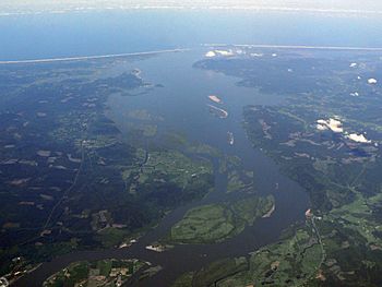
Tenasillahe Island can be seen in the lower central portion of the image.
|
|
| Geography | |
|---|---|
| Coordinates | 46°13′45″N 123°27′22″W / 46.22917°N 123.45611°W |
| Adjacent bodies of water | Columbia River |
| Highest elevation | 2 m (7 ft) |
| Administration | |
| State | Oregon |
| County | Clatsop |
| Demographics | |
| Population | 0 |
Tenasillahe Island is a small island located in the Columbia River in Oregon, United States. It sits within the part of the river where it meets the ocean, known as the Columbia River Estuary. This island is special because it's a home for important wildlife.
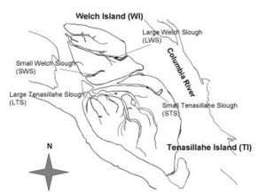
The island is found in Clatsop County, Oregon. A narrow waterway called the Clifton Channel separates Tenasillahe Island from the mainland town of Clifton. Another small channel, the Red Slough, separates it from a nearby island called Welch Island.
Island History
This island has a connection to early American exploration. The famous Lewis and Clark Expedition visited Tenasillahe Island. They explored the area during their journey to the Pacific Ocean. At that time, Tenasillahe and Welch Islands were known as the "Marshy Islands" because of their wet, low-lying land.
Home for Wildlife
Tenasillahe Island is an important place for animals. The entire island is part of the Julia Butler Hansen Refuge. This refuge is a protected area created to help a special animal. It provides a safe habitat for the Columbian white-tailed deer. These deer are a type of white-tailed deer that needs protection. The refuge helps them live and thrive in their natural environment.
What's in a Name?
The name "Tenasillahe Island" has an interesting meaning. In the Chinook language, which was spoken by Native American tribes in the area, the word "Tenasillahe" actually means "island." So, the name "Tenasillahe Island" literally means "Island Island"! This is a type of place name called a tautology, where the meaning is repeated.
 | Calvin Brent |
 | Walter T. Bailey |
 | Martha Cassell Thompson |
 | Alberta Jeannette Cassell |


