Teziutlán facts for kids
Quick facts for kids
Teziutlán
|
||
|---|---|---|
|
Town
|
||

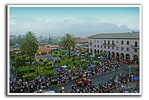
Festival of the Virgin of Carmen in the Zocalo, 21 July 2009.
|
||
|
||
| Motto(s):
La Perla de la Sierra
The Pearl of the Mountain Range |
||
| Country | ||
| State | Puebla | |
| Founded | 1552 | |
| Municipal Status | 1825 | |
| Area | ||
| • Municipality | 85.48 km2 (33.00 sq mi) | |
| Elevation | 1,990 m (6,530 ft) | |
| Population
(2005)Municipality
|
||
| • Municipality | 92,170 | |
| Time zone | UTC-6 (CST) | |
| Demonym: | Teziuteca/o | |
| Website | Official site: http://www.teziutlan.gob.mx | |
Teziutlán is a city in the northeast part of Mexico in the state of Puebla. In 2005, about 60,597 people lived there. It is also the main town for the larger Teziutlán Municipality. The municipality covers about 84.2 square kilometers (32.51 sq mi) and had a population of 88,970 people.
Some travel guides describe Teziutlán as a "picturesque colonial town." This means it has a charming, old-fashioned look from when Mexico was a Spanish colony. The city was founded on March 15, 1552. Locals used to call the area "Teziuhyotepetzintlancingo," which means "Little mount with hailstones." The name Teziutlán comes from the Nahuatl language and also means "place with hailstones."
During the time when Porfirio Díaz was president of Mexico, Teziutlán grew and became very successful. It was known as an important trading town. Many salespeople from Mexico and other countries visited to do business. The city had many businesses that traded goods with Europe and the United States. Teziutlán also got connected to the growing railway system during this time, which helped it become even more prosperous.
Geography and Location
Teziutlán Municipality covers an area of 84.2 square kilometers.
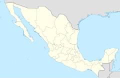
The city of Teziutlán is located at 19°49′N 97°22′W / 19.817°N 97.367°W. It is close to the border with the state of Veracruz. The city sits in a mountain range called the Sierra Madre Oriental. Several rivers flow through this area, including the Río El Calvario, Río Xóloatl, and Río Xoloco.
Climate in Teziutlán
Teziutlán has a highland subtropical climate. This means it's usually moist and cool, similar to some plateaus in southern Brazil. The weather is often mild for long periods.
| Climate data for Teziutlán | |||||||||||||
|---|---|---|---|---|---|---|---|---|---|---|---|---|---|
| Month | Jan | Feb | Mar | Apr | May | Jun | Jul | Aug | Sep | Oct | Nov | Dec | Year |
| Record high °C (°F) | 26.5 (79.7) |
29.0 (84.2) |
32.0 (89.6) |
30.0 (86.0) |
35.0 (95.0) |
30.0 (86.0) |
30.0 (86.0) |
26.0 (78.8) |
27.0 (80.6) |
27.0 (80.6) |
29.0 (84.2) |
26.5 (79.7) |
35.0 (95.0) |
| Mean daily maximum °C (°F) | 16.2 (61.2) |
17.1 (62.8) |
20.2 (68.4) |
21.8 (71.2) |
22.0 (71.6) |
20.7 (69.3) |
19.8 (67.6) |
19.4 (66.9) |
18.8 (65.8) |
17.3 (63.1) |
17.1 (62.8) |
16.5 (61.7) |
18.9 (66.0) |
| Daily mean °C (°F) | 11.2 (52.2) |
12.0 (53.6) |
14.8 (58.6) |
16.5 (61.7) |
16.8 (62.2) |
16.2 (61.2) |
15.2 (59.4) |
15.1 (59.2) |
15.0 (59.0) |
13.5 (56.3) |
12.6 (54.7) |
11.7 (53.1) |
14.2 (57.6) |
| Mean daily minimum °C (°F) | 6.2 (43.2) |
6.9 (44.4) |
9.4 (48.9) |
11.1 (52.0) |
11.6 (52.9) |
11.6 (52.9) |
10.6 (51.1) |
10.8 (51.4) |
11.1 (52.0) |
9.7 (49.5) |
8.0 (46.4) |
6.8 (44.2) |
9.5 (49.1) |
| Record low °C (°F) | −4.0 (24.8) |
−4.0 (24.8) |
−1.0 (30.2) |
1.0 (33.8) |
1.5 (34.7) |
6.5 (43.7) |
6.0 (42.8) |
7.0 (44.6) |
3.0 (37.4) |
1.5 (34.7) |
−1.5 (29.3) |
−5.0 (23.0) |
−5.0 (23.0) |
| Average precipitation mm (inches) | 52 (2.0) |
46 (1.8) |
32 (1.3) |
45 (1.8) |
81 (3.2) |
214 (8.4) |
164 (6.5) |
194 (7.6) |
298 (11.7) |
172 (6.8) |
91 (3.6) |
51 (2.0) |
1,440 (56.7) |
| Average precipitation days (≥ 0.1 mm) | 10.6 | 10.7 | 9.5 | 8.8 | 8.8 | 16.1 | 18.4 | 20.2 | 19.5 | 17.4 | 12.1 | 11.2 | 163.3 |
| Source: WeatherBase | |||||||||||||
Famous People from Teziutlán
Teziutlán is known as the birthplace of several important people.
- Manuel Ávila Camacho (1897–1955) was the President of Mexico from 1940 to 1946.
- Vicente Lombardo Toledano (1894–1968) started a major workers' union called the Confederación de Trabajadores de México (CTM).
Other notable people from the city include:
- Maximino Ávila Camacho, Manuel's brother, who was a governor of Puebla and a federal secretary.
- Juan Cordero (1824–1884), a painter who won awards for his art.
- Antonio Espino Mora (1910–1993), an actor known as "Clavillazo" who performed on stage, in movies, and on TV.
- Alfredo "El Güero" Gil (1915–1999), the lead guitarist for the famous music group El Trío Los Panchos.
- Xavier Robles (born 1949), a movie writer whose works include Rojo Amanecer.
- Francisco Rocafuerte (born 1962), an international concert pianist and conductor. He has performed and led orchestras worldwide.
- Cayetano Arámburo (born 1990), a Mexican actor who appears in TV series and soap operas.
See also
 In Spanish: Teziutlán para niños
 | George Robert Carruthers |
 | Patricia Bath |
 | Jan Ernst Matzeliger |
 | Alexander Miles |


