The Bridle Track, New South Wales facts for kids
Quick facts for kids The Bridle TrackNew South Wales |
|
|---|---|
 |
|
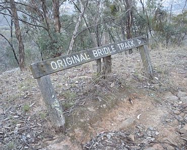
| A sign pointing to the original Bridle Track, pictured in 2009 | |
| General information | |
| Type | Track |
| Opened | c. 1850 |
| Major junctions | |
| North end | Hill End |
| Sofala | |
| South end | Bathurst |
| Location(s) | |
| Region | Central West NSW |
| LGA(s) | Bathurst Regional Council |
| Highway system | |
| Highways in Australia National Highway • Freeways in Australia Highways in New South Wales |
|
The Bridle Track is an old and famous trail in New South Wales, Australia. It's a path for walking and horses, connecting the city of Bathurst with the village of Hill End. This trail probably started around the 1850s.
The name "Bridle Track" comes from the word bridle, which is part of a horse's harness. In the 1800s, "track" meant a path for walkers or horses, not a road for carriages. This track is special because it has stayed mostly the same for over 100 years. Many other old tracks have either disappeared or become proper roads.
What is the Bridle Track Route?
The Bridle Track was a shorter way to get to Hill End. The main road, Hill End Road, went through Sofala and Sallys Flat. The Bridle Track we are talking about is the northern part of this shorter route.
The northern section of the track starts at the Winburndale Creek crossing. It goes all the way to Hill End village, where it becomes Beard Street. The path mostly follows the Macquarie River on its right side. It then follows the Turon River valley. It crosses the Turon River once. The last part is a steep climb out of the river valley to reach Hill End.
The Bridle Track's History

When Hill End was a new settlement, a narrow trail was used by people walking or riding horses. This trail wound along the steep river banks and over hills next to the Macquarie and Turon Rivers. It led to the bigger town of Bathurst.
This trail was likely first used in the 1850s and 1860s. This was when gold was first found near Hill End. A newspaper reporter mentioned a Bridle Track near Hill End in 1865. By 1871, people knew it was a much quicker way to Hill End. However, the last six miles were only good for horses, not carriages.
In the early 1870s, there was a place called Foot's. It was an accommodation house about halfway along the journey from Bathurst. In 1872, the track started to get better. At Hawkins Hill, a steep climb was changed into a winding carriage track. Miners had set up tents along the rivers. Many Chinese people grew vegetables along the track. Near Hawkins Hill was Braggs Inn. Nine miles south of Hill End, there was a mining area on the track called the Root Hog.
In 1874, a buggy pulled by one horse made it along the Bridle Track. This happened after some improvements were made. This buggy ride was much faster than the official route. It made people start talking about turning the narrow track into a proper road.
In 1876, local businesses and people began asking for the track to be improved. They wanted it to become a carriageway for horse-drawn carriages. Without this new route, all carriages had to travel from Bathurst through Peel and Sofala. This was a long journey of 97 kilometres (60 mi). It took 12 hours by Cobb & Co stagecoach. The shorter Bridle Track route would save more than 32 kilometres (20 mi). Work to widen the track began in 1878.
In 1878, a committee in Hill End suggested stopping the pony mail service on the Bridle Track. They wanted to keep a six-day-a-week mail coach service through Peel and Sofala instead. This was because the Postmaster General planned to reduce the coach mail to three days a week. It seems the Bridle Track pony mail was stopped. Later in 1878, people started a petition to bring back a mail run from Bathurst to Hill End using the Bridle Track.
The Bridle Track goes through rough and remote countryside. It has often been closed by landslides and falling rocks. In 1909, the road was closed. It closed again in 1912. The Turon Shire Council repaired the road. By 1914, it was open again for horse-drawn vehicles, like a Trap carriage. In 1917, the road closed again because of landslides and stayed closed for 12 months.
A newspaper report from 1933 said that cars had not used the road yet. It is not known when the first car finally drove on the Bridle Track.
Between 1937 and 1940, the Turon Shire Council upgraded the road. The NSW Government gave money for this work. In 1937, about 70 unemployed men worked on the project. It was a way to help people find jobs during tough times. The goal was to create a beautiful tourist route along the river. By 1939, the number of workers grew to about 250 men.
The Bridle Track Today
In 2010, the road was closed to through traffic. This was because of a big landslide at Monaghans Bluff.
Work began in February 2021 to build a new path around Monaghans Bluff. This happened after the government bought some land to make the detour possible. It was thought the work would take about 12 months. Then, the whole road could be open to traffic again.
On February 13, 2023, the Bridle Track was finally reopened. It now has a new path that goes above Monaghans Bluff. This happened after many years of effort by local people and the 4WD NSW-ACT Association. The NSW State Government and Bathurst City Council provided the money for the project.
 | Audre Lorde |
 | John Berry Meachum |
 | Ferdinand Lee Barnett |

