
The Gap, New South Wales facts for kids
Quick facts for kids The GapNew South Wales |
|
|---|---|

The Gap Creek crossing on The Gap Road
|
|

The Gap
Location in New South Wales
|
|
| Population | 62 (2016 census) |
| Postcode(s) | 2650 |
| LGA(s) | City of Wagga Wagga |
| County | Clarendon |
| State electorate(s) | Wagga Wagga |
The Gap is a small farming community located in the central east part of the Riverina region in New South Wales, Australia. It is situated very close to the larger city of Wagga Wagga.
Contents
What is The Gap Like?
The Gap is known as a farming community. This means that many people who live here work in agriculture. They might grow crops or raise animals. It's a quiet area, focused on rural life.
Where is The Gap Located?
The Gap is found in the Riverina region. This area is famous for its farming and beautiful landscapes. It's in the state of New South Wales. The community is part of the City of Wagga Wagga local government area.
How Many People Live There?
According to the 2016 Census, only 62 people lived in The Gap. This makes it a very small and close-knit community. Its postcode is 2650.
Images for kids
-
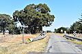
This picture shows The Gap Creek. It crosses The Gap Road in the community.
