The Leap, Queensland facts for kids
Quick facts for kids The LeapQueensland |
|||||||||||||||
|---|---|---|---|---|---|---|---|---|---|---|---|---|---|---|---|
| Population | 664 (2021 census) | ||||||||||||||
| • Density | 11.986/km2 (31.04/sq mi) | ||||||||||||||
| Postcode(s) | 4740 | ||||||||||||||
| Area | 55.4 km2 (21.4 sq mi) | ||||||||||||||
| Time zone | AEST (UTC+10:00) | ||||||||||||||
| Location |
|
||||||||||||||
| LGA(s) | Mackay Region | ||||||||||||||
| State electorate(s) | Whitsunday | ||||||||||||||
| Federal Division(s) | Dawson | ||||||||||||||
|
|||||||||||||||
The Leap is a small place located near the coast in the Mackay Region of Queensland, Australia. It's a rural area, meaning it has lots of open land and farms. In 2021, about 664 people lived in The Leap.
Contents
What is The Leap Like?
Land and Water
The Leap is bordered by Constant Creek to the north-west. This creek flows into the Coral Sea, which is part of the Pacific Ocean. There's also a place called Sand Bay just offshore.
The area has several hills and small mountains. Some of the main ones are:
- Sugarloaf Peak, which is about 254 meters (833 feet) high.
- The Leap (also known as Mount Mandurana), standing at about 306 meters (1,004 feet) tall.
- The Sister, which is around 182 meters (597 feet) high.
Nature and Farming
A part of the Pioneer Peaks National Park is right in the middle of The Leap. This park helps protect nature and wildlife. Around the park, you'll find homes spread out in rural areas.
Most of the land in The Leap is used for farming. Farmers here mostly grow sugarcane, which is used to make sugar. Some areas are also used for grazing animals.
Roads and Transport
The main road, the Bruce Highway, passes through The Leap. It connects the area to other towns. There's also the North Coast railway line nearby, but no trains stop directly in The Leap.
However, there's a special network of small tracks called cane tramways. These are used to carry the harvested sugarcane from the farms to the sugar mills for processing.
The Story Behind The Leap
The name "The Leap" comes from a sad but important historical event. Around 1860, it's believed that an Aboriginal woman, carrying her young daughter, jumped off a cliff. She did this to escape from the Queensland Native Police. The woman died, but her daughter survived the fall.
A sculpture has been built outside a local hotel to remember this Aboriginal woman and her story.
A Look Back in Time
Early School Days
The Leap Provisional School first opened its doors on March 13, 1893. It later became The Leap State School in 1909. A local hotel owner, Arthur Edward Hunter, generously donated land for the school in 1919. The school eventually closed on August 8, 1969.
Old Railway Stations
The North Coast railway line reached The Leap in 1924. In the past, there were several railway stations in the area, but they are no longer in use. These included:
- Wundaru railway station
- Mapalo railway station
- The Leap railway station
- Yakapari railway station
Heritage Sites
The Leap has a special place that is listed as a heritage site. This means it's an important historical landmark.
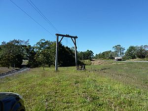
- The Leap Cane Lift: This old cane lift, located on the Bruce Highway, was used to load sugarcane onto trucks or trains. It reminds us of the area's farming history.
Where Kids Go to School
There are no schools directly in The Leap today. Children living here usually go to primary schools in nearby areas like Coningsby State School or Farleigh State School. For high school, students attend Mackay Northern Beaches State High School in Rural View or Mackay North State High School in North Mackay.
 | Delilah Pierce |
 | Gordon Parks |
 | Augusta Savage |
 | Charles Ethan Porter |


