
The Wedge (Alberta) facts for kids
Quick facts for kids The Wedge |
|
|---|---|

The Wedge (Sept. 2006)
|
|
| Highest point | |
| Elevation | 2,665 m (8,743 ft) |
| Prominence | 686 m (2,251 ft) |
| Geography | |
| Location | Alberta, Canada |
| Parent range | Fisher Range, Kananaskis Country |
| Climbing | |
| Easiest route | easy/difficult scramble |
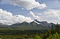
The Wedge is a cool mountain located in Alberta, Canada. It's part of the Fisher Range, which is a section of the amazing Canadian Rockies. You can find it just east of Highway 40, near the K-Country golf course and right next to Wedge Pond in Kananaskis Country. This mountain gets its name because it looks like a giant wedge!
Contents
About The Wedge Mountain
The Wedge stands tall at 2,665 m (8,743 ft) (about 8,743 feet) above sea level. It's a well-known landmark in the beautiful Kananaskis area. The mountain is part of a larger group of peaks in the Canadian Rockies, famous for their rugged beauty and outdoor adventures.
Climbing The Wedge
Many people enjoy climbing or "scrambling" up The Wedge. Scrambling is like a mix between hiking and rock climbing. It's a fun way to explore the mountain, but it can be challenging!
The Path to the Top
The journey to the top of The Wedge usually starts from the Wedge Pond parking lot. From there, climbers can choose one of two paths:
- Follow the shore of Wedge Pond counter-clockwise until a trail goes into the trees.
- Follow a cutline (a cleared path) south from a gate, which soon joins the other trail.
The first part of the climb is a nice walk through the trees. You'll gain about 850 m (2,789 ft) (2,789 feet) in height before you reach the tree line. This is where the trees become sparse, and you start to see more rocks.
Reaching the Summit
Once you're out of the trees and on the rocky parts, the best way to go up is to stay to the right, close to the cliffs. This path helps you get to the top of the rocky section. After that, it's an easier walk to what's called the "false summit." This is a high point that looks like the top, but it's not the very highest point.
From the false summit, you follow a ridge (a narrow line of high ground) to the true summit. There's one short part of the ridge that's too narrow to walk normally. Here, climbers need to use their hands and feet to hold onto the side of the ridge for about 4 m (13 ft) (13 feet). After this tricky spot, the ridge gets wider again, making the rest of the walk to the very top easier. Reaching the summit offers amazing views of the surrounding mountains and valleys!
Images for kids
-
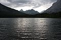
View from Wedge Pond.
-
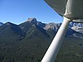
The wedge.
-
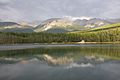
Looking north from Wedge Pond.
-
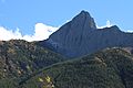
The Wedge
-
The Wedge


.jpg)
.jpg)
