Thesprotia facts for kids
Quick facts for kids
Thesprotia
Περιφερειακή ενότητα
Θεσπρωτίας |
|
|---|---|

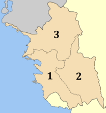
Municipalities of Thesprotia
|
|
| Country | Greece |
| Administrative region | Epirus |
| Area | |
| • Total | 1,515 km2 (585 sq mi) |
| Population | |
| • Total | 40,804 |
| • Density | 26.933/km2 (69.757/sq mi) |
| Time zone | UTC+2 (EET) |
| • Summer (DST) | UTC+3 (EEST) |
| Postal code |
46x xx
|
| Area code(s) | 266x0 |
| Vehicle registration | ΗΝ |
Thesprotia is a beautiful area in Greece. It is one of the "regional units" of Greece, which is like a county or a province. It is part of the Epirus region. The main town and capital is Igoumenitsa. Thesprotia got its name from the Thesprotians. They were an ancient Greek tribe who lived there a very long time ago.
Contents
History of Thesprotia
This area was an important part of ancient Greece. It was settled by the ancient Greek tribe called the Thesprotians. They lived here, with other tribes like the Molossians and Chaonians nearby.
Thesprotia is even mentioned in famous ancient stories. The hero Odysseus from Greek myths sailed here. He is said to have married a local queen named Callidice.
Later, Thesprotia joined the Epirote League. This was a group of ancient Greek tribes. Then, it became part of the Roman Empire. After the Roman Empire split, Thesprotia was part of the Eastern Roman (Byzantine) Empire. This lasted until the Middle Ages. For a while, in the 9th to 11th centuries, it was ruled by Bulgarians. Around 1430, the area was taken over by the Ottomans.
Name Changes Over Time
From the 8th or 9th century until the 15th century, the region was called Vagenetia. This name came from a Slavic tribe called the Baiounitai. They arrived in the early 7th century.
Later, during the time of the Ottoman Empire, the area was known as Chameria. Around 1910, most of modern Thesprotia was called Sancak of Resadiye, Çamlık Sancak, or Igoumenitsa Sancak.
Thesprotia remained under Ottoman rule until 1913. It became part of Greece after the Ottomans lost the First Balkan War. In 1937, Thesprotia became its own separate area, called a prefecture. In 1923, about 60,705 people lived in Thesprotia. After World War II, the number of Muslim Albanians in the area changed greatly. By 1951, only 77 individuals were counted.
Geography and Climate
Thesprotia shares its northern border with Albania. To the east, it borders the Ioannina region. To the south, it borders Preveza. The Ionian Sea is to its west.
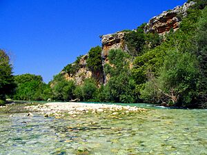
Much of Thesprotia is mountainous. Most of the flat land for farming is in the valleys. These valleys are in the central, southern, and western parts of the region. Thesprotia has two rivers that are famous in Greek mythology: the Thyamis and the Acheron. These rivers are known for their reedbeds and plane trees.
The climate along Thesprotia's coast is Mediterranean. This means it has warm, dry summers and mild, wet winters. The eastern parts and higher mountains have colder winters, like a semi-alpine climate.
How Thesprotia is Governed

The regional unit of Thesprotia is divided into three main areas called municipalities. These are like local government districts. They are:
- Filiates (3)
- Igoumenitsa (1)
- Souli (2)
Changes in Local Government
Thesprotia was first set up as a "prefecture" in 1937. A prefecture is a type of administrative area in Greece. In 2011, Greece made big changes to its local government. This was part of the Kallikratis reform. The old prefecture of Thesprotia became the new "regional unit" of Thesprotia. It covers the same area.
At the same time, the municipalities were reorganized. The table below shows how the old municipalities were grouped into the new ones:
| New municipality | Old municipalities | Seat |
|---|---|---|
| Filiates | Filiates | Filiates |
| Sagiada | ||
| Igoumenitsa | Igoumenitsa | Igoumenitsa |
| Margariti | ||
| Parapotamos | ||
| Perdika | ||
| Syvota | ||
| Souli | Souli | Paramythia |
| Acherontas | ||
| Paramythia |
Thesprotia also used to have smaller areas called provinces. These included Thyamida, Filiates, Margariti, and Souli. However, these provinces no longer have any official legal status in Greece.
Economy and Tourism
Thesprotia has traditionally been one of the less wealthy and more isolated areas of Greece. The two main ways people make a living here are through farming and tourism. Farming has always been the most important activity.
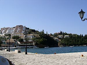
The region's many beaches are a big draw for tourists. The resort town of Syvota is especially popular. Visitors can also explore the ruins of ancient cities, like Gitani.
Transportation and Roads
In 1996, work began on a major highway called Egnatia Odos. This road connects the Ionian Sea coast at Igoumenitsa all the way to Thessaloniki and the Greek-Turkish borders. It was fully opened in 2009.
Other important roads in Thesprotia include Greek National Road 6 (connecting Igoumenitsa to Ioannina and Larissa) and Greek National Road 18 (connecting Filiates to Paramythia and Preveza). In 2009, a new highway project started. It will connect Igoumenitsa to Saranda in Albania, passing through Sagiada and Konispol.
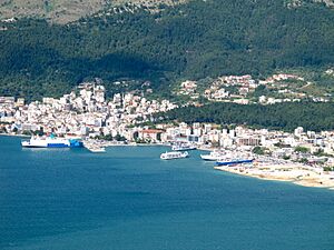
The port of Igoumenitsa is very important. It has ferry routes to the Greek islands of Corfu and Paxoi. It also connects to Italy, making it a gateway for travel.
See also
- List of settlements in Thesprotia
- Ancient Thesprotia
- Thesprotians
 | George Robert Carruthers |
 | Patricia Bath |
 | Jan Ernst Matzeliger |
 | Alexander Miles |


