
Igoumenitsa facts for kids
Quick facts for kids
Igoumenitsa
Ηγουμενίτσα
|
|
|---|---|

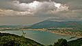
View of a part of the city and its old port
|
|

Igoumenitsa
Location in Greece
|
|
| Country | Greece |
| Administrative region | Epirus |
| Regional unit | Thesprotia |
| Area | |
| • Municipality | 428.4 km2 (165.4 sq mi) |
| • Municipal unit | 111.8 km2 (43.2 sq mi) |
| Elevation | 13 m (43 ft) |
| Population
(2021)
|
|
| • Municipality | 25,698 |
| • Municipality density | 59.986/km2 (155.363/sq mi) |
| • Municipal unit | 18,562 |
| • Municipal unit density | 166.03/km2 (430.01/sq mi) |
| Demonym(s) | Igoumenitsiote |
| Community | |
| • Population | 10,315 (2021) |
| Time zone | UTC+2 (EET) |
| • Summer (DST) | UTC+3 (EEST) |
| Postal code |
461 00
|
| Area code(s) | 26650 |
| Vehicle registration | ΗΝ |
| Website | www.igoumenitsa.gr |
Igoumenitsa (Greek: Ηγουμενίτσα, romanized: Igoumenítsa) is a lively coastal city in northwestern Greece. It is the main city of the area called Thesprotia.
Igoumenitsa is a very important port for Thesprotia and Epirus. It is one of Greece's biggest ports for passengers. It connects mainland Greece with the Ionian Islands and Italy. The city is built on the eastern side of the Gulf of Igoumenitsa, which is part of the Ionian Sea. The city's economy relies on shipping, transportation, services, farming, and tourism. A long highway called the A2 motorway (Egnatia Odos) ends in Igoumenitsa. This makes it a popular starting point for tourists from Europe and a stopping point for trucks from Turkey.
Igoumenitsa has many shops, schools, and offices. It also has a university department, a library, and an archaeological museum. You can find sports stadiums, tennis courts, a courthouse, and a medical clinic here. The city is built on the slopes of a forested mountain. It spreads out around the beautiful gulf.
In 2021, about 25,698 people lived in the wider Igoumenitsa area. About 18,562 people lived in the main part of the city. Igoumenitsa is famous for its surrounding forests and clear blue waters. Drepanos Beach, nearby, is one of the longest sandy beaches in the area. It stretches for over 7 kilometers!
Contents
City Names Through History
Igoumenitsa has been called different names over time. In the Middle Ages, it was mentioned in an old document from 1361. A Greek map from the 1400s called it Igoumenitza (Greek: Ηγουμενίτζα).
Later, during the time of the Ottoman Empire, it was known as Grava (Greek: Γράβα) or Reşadiye. In 1938, it became the capital city of Thesprotia. Its name was then changed to the current Igoumenitsa. The name comes from the Greek word Igoumeni, which means "commander" or "abbot". The name has also been used as Gomenizza in Italian and Gumenicë in Albanian.
A Look at Igoumenitsa's Past

Long ago, near where Igoumenitsa is today, there was an important ancient town called Gitanae (also known as Titana). It was one of the most important towns in the Kingdom of Thesprotis around 400 BC. The town covered a large area, about 28 hectares. Its walls were 2,400 meters long and had four gates. Inside, curved walls divided the city into two parts.
The most interesting tower was round and stood at the top of a hill. People think it might have been a religious place. Digs have found a theatre that could seat 2,500 people. Ruins of two temples have also been found.
Gitanae was a meeting place for the Epirote League, a group of ancient Greek states. The city was destroyed by the Romans in 167 BC. Later, it became part of the Roman Empire.

"Gomenizze" by Vincenzo Coronelli (1687)
|
During the Balkan wars in 1913, the region was freed from Ottoman rule. The city was then called Grava until 1938. That's when it became the capital of Thesprotia and was renamed Igoumenitsa. The town was badly damaged in 1944 during World War II. A new town grew up around the new ferry terminal in the 1950s and 1960s.
Igoumenitsa was burned by the Italian Fascist army in November 1940. During World War II, many people living in Igoumenitsa had to leave their homes. They sought safety in the mountains. After the war, some groups of people who had lived in Igoumenitsa moved further north.
Igoumenitsa's Municipality


The current municipality of Igoumenitsa was created in 2011. This happened when five smaller municipalities joined together. These smaller areas became parts of the new, larger municipality. The total area of the municipality is about 428 square kilometers. The main part of Igoumenitsa city covers about 111 square kilometers.
Getting Around: Transport

Many car–ferry ships stop at Igoumenitsa. These ships travel between Patras, Greece, and Brindisi, Italy. Other ships also go to and from cities like Ancona, Bari, or Venice in Italy. There are also frequent ferries for passengers and cars to and from Corfu.
The A2 motorway was opened in 2009. It is part of the ![]() . This highway has greatly improved travel to Thessaloniki and Turkey. It has cut down travel time by several hours.
. This highway has greatly improved travel to Thessaloniki and Turkey. It has cut down travel time by several hours.
Ports of Igoumenitsa

Igoumenitsa has two ports: the Old Port and the New Port. The New Port is the second busiest passenger port in Greece. Only Piraeus is busier. It handles more passengers than the ports of Iraklion and Patras.
Here are some of the sea routes that connect to Igoumenitsa:
|
Travel within Greece
|
International Travel |
The port of Igoumenitsa is becoming a major "Connection Portal." It links Greece with the rest of Europe. It also connects Europe with the Balkans, the Black Sea, and the Middle East. This is happening by developing ways to combine sea and road transport.
The first part of the New Port construction was finished in 2012. This made Igoumenitsa a modern, large port in the Mediterranean Sea. It can now handle many passengers, goods, and tourists. The second part was finished by 2016. This allowed the port to serve large cruise ships. There are also plans to create a freight center. This will help commercial traffic and make Igoumenitsa an international center for logistics (moving goods).
Igoumenitsa handles a large share of Greece's maritime traffic. It serves over 61% of passenger traffic, 67% of car traffic, and 55% of truck traffic each year.
Population Growth
The town of Igoumenitsa has about 10,315 residents. The wider urban area has about 18,562 people. The total population of the Municipality of Igoumenitsa is 25,698 permanent citizens. The population of Igoumenitsa has grown quickly in recent years. This is because of the increased traffic and activity at the New Port.
Geography and Climate
Igoumenitsa is in the northwestern part of Greece. It is located in the region of Thesprotia, which is part of Epirus. Like much of Greece's west coast, Igoumenitsa has a hot-summer Mediterranean climate. This means it has mild to cool, rainy winters and hot, fairly dry summers.
Tourism and Fun Things to Do
Igoumenitsa is famous for its green forests and clear blue waters. Many tourists, especially from Italy, visit the area. The city offers many ways to enjoy nature. You can go for walks, jog on the beach or in the mountains, or go hiking. You can also enjoy sports or boating.
The city has Blue Flag beaches like Drepanos and Makrygiali. These beaches have very clear waters and are about 7 kilometers long. They are located on the northwestern edge of the Gulf of Igoumenitsa.
In recent years, Igoumenitsa has become a popular stop for cruise ships. Visitors can explore archaeological sites and the natural beauty of Thesprotia. They can also discover the entire Ionian coast.
Archaeological Museum of Igoumenitsa

The archaeological museum in Igoumenitsa opened in 2009. It is on the north side of the city. The museum has five main sections. They show the history and culture of the Thesprotia region. This covers ancient times all the way to the Byzantine period.
The sections cover:
- Archaeological and historical background
- Settlements from historical times
- Public life
- Private life
- Burial customs
International Connections
Igoumenitsa has special connections with other cities around the world. These are called "twin cities."
Twin Cities
Igoumenitsa is twinned with:
Consulates and Diplomatic Offices
Igoumenitsa also hosts offices from other countries. These are called consulates.
Images for kids
-
View of the city
-
Ferry terminal
-

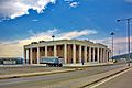
Thesprotia Regional unit offices building
-
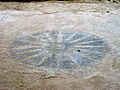
Mosaic depicting the Vergina Sun, Titana archeological site
-
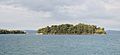
The Agios Dionysios island, at the Gulf of Igoumenitsa


See also
 In Spanish: Igumenitsa para niños
