Thevalakkara facts for kids
Quick facts for kids
Thevalakkara
Deva Loka Kara ( Area of GODS)
|
|
|---|---|
|
Village
|
|

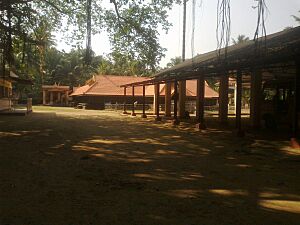
Thekkan Guruvayur Temple within the village
|
|
| Country | |
| State | Kerala |
| District | Kollam |
| Taluk | Karunagappally |
| Government | |
| • Type | Gram Panchayat |
| Area | |
| • Total | 16.92 km2 (6.53 sq mi) |
| Elevation | 10 m (30 ft) |
| Population
(2011)
|
|
| • Total | 42,977 |
| • Density | 2,540.0/km2 (6,578.6/sq mi) |
| Languages | |
| • Official | Malayalam, English |
| Time zone | UTC+5:30 (IST) |
| PIN |
690524
|
| STD code | 0476287 |
| Vehicle registration | KL-23 |
| Nearest city | Karunagappally |
| Lok Sabha constituency | Kollam |
| Vidhan Sabha constituency | Chavara |
Thevalakkara is a lovely village in the state of Kerala, India. It's part of the Kollam District and is located in the Karunagappally area. The village is quite close to the Indian Ocean coast. It's about 13 kilometers north of Kollam city and 7 kilometers southeast of Karunagappally.
Thevalakkara is a place where different cultures live together peacefully. You can find a Devi temple, a church, and a mosque here. For many years, a special type of wood workshop called a kadappa was famous in Thevalakkara. This is where large wooden masts for ships were made. In 2011, about 42,977 people lived in this village.
Exploring Thevalakkara's Location
Thevalakkara is located on the northwestern side of the beautiful Ashtamudi Lake. This lake is a large body of water that adds to the village's natural beauty. A major road, the National Highway 183A, goes right through the village, making it easy to travel to and from Thevalakkara. The village is about 10 meters above sea level. This means it's not very high up from the ocean.
Understanding Thevalakkara's Weather
Thevalakkara has a Tropical Monsoon Climate. This means it's generally warm all year round, and it experiences a lot of rain during certain months. The wettest month in Thevalakkara is June, when it gets about 418 millimeters of rain on average. The driest month is January, with only about 25 millimeters of rain. This type of climate is common in many parts of India.
| Climate data for Thevalakkara | |||||||||||||
|---|---|---|---|---|---|---|---|---|---|---|---|---|---|
| Month | Jan | Feb | Mar | Apr | May | Jun | Jul | Aug | Sep | Oct | Nov | Dec | Year |
| Mean daily maximum °C (°F) | 30.9 (87.6) |
32 (90) |
32.2 (90.0) |
31.2 (88.2) |
29.9 (85.8) |
28.2 (82.8) |
27.8 (82.0) |
27.8 (82.0) |
28.3 (82.9) |
28.6 (83.5) |
28.9 (84.0) |
29.7 (85.5) |
29.6 (85.4) |
| Daily mean °C (°F) | 26.5 (79.7) |
27.3 (81.1) |
28 (82) |
27.9 (82.2) |
27.3 (81.1) |
26 (79) |
25.5 (77.9) |
25.5 (77.9) |
25.8 (78.4) |
25.9 (78.6) |
26 (79) |
26.2 (79.2) |
26.5 (79.7) |
| Mean daily minimum °C (°F) | 22.9 (73.2) |
23.5 (74.3) |
24.7 (76.5) |
25.4 (77.7) |
25.4 (77.7) |
24.6 (76.3) |
24.1 (75.4) |
24 (75) |
24.1 (75.4) |
24 (75) |
23.7 (74.7) |
23.3 (73.9) |
24.1 (75.4) |
| Average rainfall mm (inches) | 25 (1.0) |
30 (1.2) |
75 (3.0) |
167 (6.6) |
314 (12.4) |
418 (16.5) |
363 (14.3) |
294 (11.6) |
247 (9.7) |
267 (10.5) |
189 (7.4) |
65 (2.6) |
2,454 (96.8) |
| Source: Climate-Data.org | |||||||||||||
Who Lives in Thevalakkara?
Based on the 2011 Indian Census, Thevalakkara had about 10,473 homes. The total number of people living there was 42,977. Out of these, 20,278 were boys and men, and 22,699 were girls and women.
The village has a high literacy rate, which means many people can read and write. About 82.52% of the people in Thevalakkara are literate. This includes 16,960 literate males and 18,506 literate females. The special code for Thevalakkara in the census records is 628361.
 | Jackie Robinson |
 | Jack Johnson |
 | Althea Gibson |
 | Arthur Ashe |
 | Muhammad Ali |


