Thornton, Iowa facts for kids
Quick facts for kids
Thornton, Iowa
|
|
|---|---|

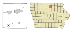
Location of Thornton, Iowa
|
|
| Country | |
| State | |
| County | Cerro Gordo |
| Area | |
| • Total | 1.24 sq mi (3.22 km2) |
| • Land | 1.24 sq mi (3.22 km2) |
| • Water | 0.00 sq mi (0.00 km2) |
| Elevation | 1,188 ft (362 m) |
| Population
(2020)
|
|
| • Total | 400 |
| • Density | 321.54/sq mi (124.18/km2) |
| Time zone | UTC-6 (Central (CST)) |
| • Summer (DST) | UTC-5 (CDT) |
| ZIP code |
50479
|
| Area code(s) | 641 |
| FIPS code | 19-77880 |
| GNIS feature ID | 0462227 |
| Website | http://www.thornton-iowa.com/ |
Thornton is a city located in Cerro Gordo County, Iowa, in the United States. In 2020, about 400 people lived there. Thornton is part of the Mason City area.
Contents
About Thornton's Location
Thornton, Iowa, is found at these coordinates: 42.944972 degrees North and 93.384115 degrees West.
The city covers a total area of about 1.25 square miles (3.22 square kilometers). All of this area is land.
People Living in Thornton
| Historical populations | ||
|---|---|---|
| Year | Pop. | ±% |
| 1900 | 299 | — |
| 1910 | 271 | −9.4% |
| 1920 | 317 | +17.0% |
| 1930 | 383 | +20.8% |
| 1940 | 398 | +3.9% |
| 1950 | 441 | +10.8% |
| 1960 | 449 | +1.8% |
| 1970 | 410 | −8.7% |
| 1980 | 442 | +7.8% |
| 1990 | 431 | −2.5% |
| 2000 | 422 | −2.1% |
| 2010 | 422 | +0.0% |
| 2020 | 400 | −5.2% |
| Source: and Iowa Data Center Source: |
||
Population in 2020
In 2020, the city of Thornton had 400 residents. Most of the people living there were White (95.2%). A small number were from other racial backgrounds. About 2.8% of the population was Hispanic or Latino.
The average age of people in Thornton was 38.0 years. About 22% of residents were under 20 years old.
Population in 2010
In 2010, Thornton had 422 residents. The population density was about 337.6 people per square mile. Most residents (98.6%) were White.
The average age in 2010 was 45.3 years. About 20.4% of residents were under 18.
Matt Ingebretson is the mayor of Thornton.
Schools and Education
Thornton is part of the West Fork Community School District. This district was created in 2011. It formed when several smaller school districts joined together.
The Sheffield–Chapin–Meservey–Thornton (SCMT) Community School District and the Rockwell–Swaledale Community School District merged to form West Fork. Before the full merger, Thornton had already started sharing classes with West Fork schools in 2008.
The Thornton Public Library serves the community.
Thornton School Building
The school building in Thornton served the community for many years. Its sports teams were called the Lancers.
The original school building was destroyed in a fire. A new school opened in 1936. In 1955, new classrooms, offices, a gym, and a library were added.
Over time, different school districts merged. In 1963, the Thornton school became a high school for the new Meservey–Thornton district. Later, junior high students also moved to this building.
In 1983, the Meservey School closed. This meant the Thornton School taught students from kindergarten all the way through 12th grade.
Due to fewer students, the school districts decided to work together. In 2008, the S-C, M-T, and Rockwell–Swaledale districts formed the West Fork school system. Their new mascot became the "Warhawks."
The Thornton school building closed after the 2007–08 school year, after 72 years of service. All students now attend schools in Sheffield and Rockwell. In 2007, the Lancers mascot was no longer used. A farewell parade was held to celebrate the school.
The Thornton school building was torn down in 2012. This happened because a plan to sell the building did not work out.
See also
 In Spanish: Thornton (Iowa) para niños
 | Kyle Baker |
 | Joseph Yoakum |
 | Laura Wheeler Waring |
 | Henry Ossawa Tanner |


