
Thorpe Ford Covered Bridge facts for kids
Quick facts for kids Thorpe Ford Covered Bridge |
|
|---|---|

Thorpe Ford Covered Bridge
|
|
| Coordinates | 39°38′13.45″N 87°15′52.75″W / 39.6370694°N 87.2646528°W |
| Carries | Rosedale-Catlin Road |
| Crosses | Big Raccoon Creek, Indiana |
| Locale | Parke, Indiana, United States |
| Official name | Thorpe Ford Covered Bridge |
| Named for | Thorpe Ford |
| Maintained by | Parke County |
| WGCB Number |
|
| Characteristics | |
| Design | National Register of Historic Places |
| Total length | 181 ft (55 m)163ft +9ft overhangs on each end |
| Width | 16 ft (4.9 m) |
| Height | 13 ft (4.0 m) |
| History | |
| Constructed by | Britton, J.A. |
| MPS | Parke County Covered Bridges TR |
| NRHP reference No. | 78000413 |
| Added to NRHP | Dec 22, 1978 |
| Lua error in Module:Location_map at line 420: attempt to index field 'wikibase' (a nil value). | |
The Thorpe Ford Covered Bridge is a historic bridge located northeast of Rosedale, Indiana. It's a special type of bridge called a "covered bridge" because it has a roof and walls, just like a house! This helps protect the wooden parts of the bridge from weather.
The bridge was built in 1912 by a builder named Joseph A. Britton. It uses a design called a Burr Arch Truss, which is a strong way to build bridges. In 1978, the Thorpe Ford Covered Bridge was added to the National Register of Historic Places. This means it's recognized as an important historical site in the United States.
Contents
History of the Bridge
Why the Bridge Was Built
The area where the bridge stands was once known as Thorpe Ford. It was named after a family who owned a lot of land nearby. A "ford" is a shallow place in a river or creek where people and animals can cross easily.
The idea for building a bridge here came from a local leader named J.M. May. He was a County Commissioner, which is like an elected official who helps manage the county. One day, he got lost trying to find a shortcut between Rosedale and Rockville. After getting turned around many times, he promised that a new bridge would be built to make travel easier.
A Busy Roadway
Once the Thorpe Ford Covered Bridge was built, the road became a very important route. It connected the cities of Terre Haute and Crawfordsville. People even nicknamed it the "Ben Hur Highway." This was in honor of General Lew Wallace, a famous writer from Crawfordsville who wrote the popular novel Ben Hur.
Imagine this: many circus animals, including elephants, used this bridge! They crossed it on their way to their winter camp in Peru, Indiana.
Changes Over Time
In the 1930s, a government program called the WPA paved the road with concrete. However, a new major highway, U.S. Highway 41, was built in the 1920s. This new highway took away most of the traffic from the Thorpe Ford Bridge.
Even though less regular traffic used it, the bridge was still used by heavy farm vehicles. By 1960, the bridge was getting old and worn out from all the heavy loads. It was declared unsafe, which means it was "condemned." In 1961, a new route was built around the bridge, and it was no longer used for everyday traffic.
Images for kids
-
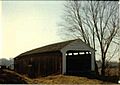
The Thorpe Ford Covered Bridge, a historic landmark.

