
Thury-Harcourt facts for kids
Quick facts for kids
Thury-Harcourt
|
||
|---|---|---|
 |
||
|
||

Thury-Harcourt
Location in France

Thury-Harcourt
Location in Normandy
|
||
| Country | France | |
| Region | Normandy | |
| Department | Calvados | |
| Arrondissement | Caen | |
| Canton | Thury-Harcourt | |
| Intercommunality | Suisse Normande | |
| Area
1
|
4.90 km2 (1.89 sq mi) | |
| Population
(2008)
|
1,914 | |
| • Density | 390.6/km2 (1,011.7/sq mi) | |
| Time zone | UTC+01:00 (CET) | |
| • Summer (DST) | UTC+02:00 (CEST) | |
| INSEE/Postal code |
14689 /14220
|
|
| Elevation | 18–156 m (59–512 ft) (avg. 100 m or 330 ft) |
|
| 1 French Land Register data, which excludes lakes, ponds, glaciers > 1 km2 (0.386 sq mi or 247 acres) and river estuaries. | ||
.svg)
Thury-Harcourt was a small town, or "commune," located in the northwest of France. It was part of the region called Basse-Normandie and the department named Calvados. Think of a commune as a local government area, similar to a small town or village.
On January 1, 2016, Thury-Harcourt joined with other nearby towns. They formed a new, larger commune called Le Hom. This means Thury-Harcourt no longer exists as a separate commune.
Images for kids
-
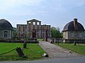
Frontage of the Château of Thury-Harcourt
-
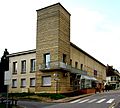
Town hall
-
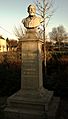
Statue of Paul Heroult


See also
 In Spanish: Thury-Harcourt para niños

All content from Kiddle encyclopedia articles (including the article images and facts) can be freely used under Attribution-ShareAlike license, unless stated otherwise. Cite this article:
Thury-Harcourt Facts for Kids. Kiddle Encyclopedia.