Tiétar (river) facts for kids
Quick facts for kids Tiétar |
|
|---|---|

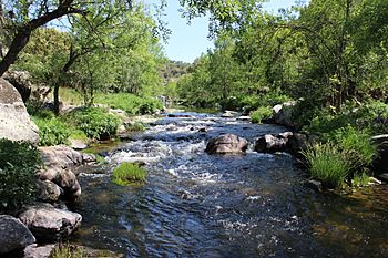
The Tiétar in the province of Toledo
|
|
 |
|
| Country | Spain |
| Physical characteristics | |
| Main source | Puerto de la Venta del Cojo 1,200 m (3,900 ft) |
| River mouth | Tagus 215 m (705 ft) |
| Length | 170 km (110 mi) |
| Basin features | |
| Progression | Tagus→ Atlantic Ocean |
| Basin size | 4,459 km2 (1,722 sq mi) |
| Tagus Basin | |
The Tiétar River is an important river in Spain. It's like a smaller helper river, also known as a tributary, that flows into the much larger Tagus River. The Tiétar is about 170 kilometers (106 miles) long.
Where the Tiétar River Starts
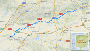
The Tiétar River begins its journey high up in the mountains. Its source is in the Sierra de Gredos mountain range. This area is known for its beautiful, rugged peaks. The river starts at an elevation of about 1,200 meters (3,937 feet) above sea level. Imagine water trickling down from high up in the mountains to start a long river!
The River's Journey
As the Tiétar River flows, it travels through several different areas of Spain. It passes through parts of the Castile and León region, then Castilla–La Mancha, and finally Extremadura. The river collects water from a large area, known as its drainage basin, which covers about 4,459 square kilometers (1,722 square miles).
The Tiétar River eventually meets the Tagus River. This meeting point is near a special place called Monfragüe. Monfragüe is famous for its natural park, which is home to many amazing animals and plants. When the Tiétar joins the Tagus, it's at a much lower elevation, around 215 meters (705 feet) above sea level.
Importance of the Tiétar River
The Tiétar River is important for the areas it flows through. It provides water for farming and helps support the local environment. The river's path creates different habitats for wildlife. The areas around the Tiétar are often green and fertile, thanks to the water it carries.
See Also
 In Spanish: Río Tiétar para niños
 | Audre Lorde |
 | John Berry Meachum |
 | Ferdinand Lee Barnett |

