Timberon, New Mexico facts for kids
Quick facts for kids
Timberon, New Mexico
|
|
|---|---|

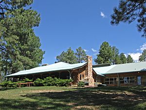
Timberon Lodge
|
|

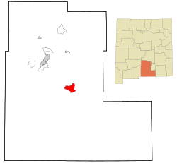
Location of Timberon, New Mexico
|
|
| Country | United States |
| State | New Mexico |
| County | Otero |
| Area | |
| • Total | 20.31 sq mi (52.61 km2) |
| • Land | 20.29 sq mi (52.55 km2) |
| • Water | 0.02 sq mi (0.06 km2) |
| Elevation | 6,975 ft (2,126 m) |
| Population
(2020)
|
|
| • Total | 345 |
| • Density | 17.00/sq mi (6.57/km2) |
| Time zone | UTC-7 (Mountain (MST)) |
| • Summer (DST) | UTC-6 (MDT) |
| ZIP code |
88350
|
| Area code(s) | 575 |
| FIPS code | 35-77950 |
| GNIS feature ID | 2409323 |
Timberon is a small community in Otero County, New Mexico, United States. It's located high up in the Sacramento Mountains. This area is right on the edge of the Lincoln National Forest. In 2020, about 345 people lived there.
Timberon has a nine-hole golf course, which is a place to play golf. There's also a lodge, a swimming pool, and a church. The community has its own airstrip and a volunteer fire department. Many people see Timberon as a place for retirement or a vacation spot. Kids who live in Timberon travel by bus to Cloudcroft for public school.
Contents
Geography of Timberon
Timberon is found in a beautiful forested valley. This valley is known as Sacramento Canyon. It sits on the southern side of the Sacramento Mountains. A stream called Sacramento Creek flows through the valley. This creek sometimes dries up, but it flows southeast.
The community also reaches into other smaller canyons. These include Arkansas Canyon, Graveyard Canyon, and Carrisa Canyon. The height above sea level in Timberon changes. It ranges from about 6,900 to 7,200 feet (2,100 to 2,200 meters). Jefferies Peak is a mountain directly to the east. It is 8,501 feet (2,591 meters) tall. Culp Peak is to the west and is 7,280 feet (2,219 meters) tall.
The total area of Timberon is about 20.2 square miles (52.3 square kilometers). All of this area is land.
History of Timberon
The land where Timberon is today was bought in 1933. Judge Paul Moss bought it from the State of New Mexico. He had a hunting lodge there and also cut some trees. In the 1960s, Willie Farah owned the land. He was from El Paso, Texas and built an airstrip there.
The community really started to grow in March 1969. That's when the North American Land Development Corporation bought the property. The volunteer fire department started in 1974. Their firehouse was finished in 1981. The post office also opened in 1981.
Something unusual happened in 1976. A missile from White Sands Missile Range went off course. It landed right in the middle of the community. The main road leading into Timberon was paved in 2005. In July 2016, a large fire happened in Timberon. It destroyed almost 80 buildings, including 44 homes.
Population and People
| Historical population | |||
|---|---|---|---|
| Census | Pop. | %± | |
| 2020 | 345 | — | |
| U.S. Decennial Census | |||
In 2020, the population of Timberon was 345 people. In 2000, there were 309 people living there. At that time, there were 145 households. A household is a group of people living together. Most households were married couples. About 14.5% of households had children under 18.
The average age of people in Timberon in 2000 was 54 years old. About 28.5% of the population was 65 years or older. This shows that many older adults live in Timberon.
Education for Timberon Students
Children in Timberon attend schools in the Cloudcroft Municipal Schools district.
In the 1970s, students were bused to an elementary school in Weed, New Mexico. Winter travel was difficult because of snow and ice. So, a special elementary school was opened in Timberon in December 1980. This school was open only during the three winter months. It was called the Little Red School House. It taught students from Kindergarten to Sixth Grade. This school was part of the Alamogordo School District.
By 1992, the Little Red School House became a year-round school. The school in Weed closed in August 1992. This was because all the students from Weed decided to go to the Timberon school instead. In November 1992, the Cloudcroft school district decided to include Timberon. The Little Red Schoolhouse continued under Cloudcroft until May 2002. After that, all students from Timberon started taking buses to Cloudcroft for school.
See also
 In Spanish: Timberon (Nuevo México) para niños


