Timiș (river) facts for kids
Quick facts for kids TimișTamiš (Тамиш) |
|
|---|---|
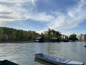
The Timiș (Tamiš) in Pančevo
|
|
 |
|
| Country | Romania, Serbia |
| Counties/Province | Caraș-Severin, Timiș, Vojvodina |
| Towns | Caransebeș, Lugoj, Pančevo |
| Physical characteristics | |
| Main source | Semenic Mountains, Romania |
| River mouth | Danube near Pančevo, Serbia 44°50′53″N 20°38′08″E / 44.84806°N 20.63556°E |
| Length | 359 km (223 mi) |
| Basin features | |
| Progression | Danube→ Black Sea |
| Basin size | 10,280 km2 (3,970 sq mi) |
| Tributaries |
|
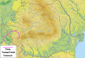
The Timiș or Tamiš is a river that flows through two countries: Romania and Serbia. It is about 359 kilometers (223 miles) long. The Timiș river joins the mighty Danube river near a city called Pančevo in northern Serbia. Because it is so important to the area, people sometimes call it the "spine of the Banat" region.
Contents
What's in a Name?
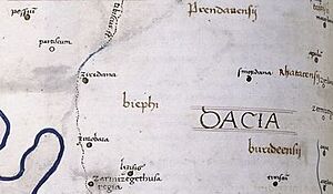
In ancient times, the river had different names. The Romans called it Tibiscus. The ancient Greeks knew it as Tibisis.
An old writer named Edward Gibbon also called it the Teyss. He wrote that the Romans thought they crossed many rivers in Hungary. But he believed it might have been the same winding river, the Teyss or Tibiscus, appearing in different places.
Where is the Timiș River?
The area that drains into the Timiș River is about 10,280 square kilometers (3,970 square miles). A large part of this area, about 7,310 square kilometers (2,820 square miles), is in Romania. The river is part of the Black Sea drainage system, just like the Danube.
The Timiș flows for 241 kilometers (150 miles) in Romania. It then flows for 118 kilometers (73 miles) through Serbia. At its end, where it meets the Danube, the river carries about 47 cubic meters (1,660 cubic feet) of water per second.
The river starts near the Semenic mountain resort in the Banat Mountains in Romania. It flows through the Trei Ape Reservoir. After leaving the mountains, it enters the flat Banat plain near Lugoj. Here, the river becomes slow and winding. The city of Pančevo in Serbia is an important industrial port on the Timiș.
Near where the river meets the Danube, there is a forest called Pančevo Forest. This forest covers 300 hectares (740 acres) of marshy land. It is home to many types of trees and 176 kinds of birds and mammals. Special creatures called magnificent bryozoans have also been found in the river.
River Features and Fun
Between 2017 and 2019, Romania and Serbia worked together to improve the area around the Timiș River. They added bird-watching towers, benches, and small bridges. You can also find billboards, signs, and trash cans.
New bicycle paths were built along the river. Places for fishing were also set up. In Pančevo, you can even rent catamarans, canoes, and bicycles to explore the river.
The riverbank in Pančevo was made into a nice walking area in the 1980s. There are plans to make it even better by 2023. This project is called "Pančevo Promenade." It will include sports fields, a skate park, and bike paths. A new footbridge will connect the city to the City Forest on the other side of the river. The forest will also be restored.
Long ago, in 1891, Pančevo had a beach on the Timiș where people paid to swim. Later, two more beaches opened. One was called Waltman's, and the other was the municipal beach. Sports clubs even held swimming competitions there until the 1970s.
Today, there are several beaches along the river outside Pančevo. At Idvor, new trees were planted to help nature. A small bridge was added, and crushed stone was used to help clean the water. Other beaches like Skela in Glogonj and Pesak in Jabuka have also been improved. Some now have restaurants on barges and sports fields.
River Travel
The lower part of the Timiș River has been changed to make it easier for boats to travel. The last 53 kilometers (33 miles) of the river are open for navigation.
Pančevo had a busy port as early as the 1600s. It became a main hub for river travel in the Banat region. Goods like grain, beer, silk, and salt were shipped. Later, passenger boats also connected Pančevo to Belgrade, the capital of Serbia. As Pančevo grew, so much traffic was on the Timiș that the river had to be straightened. Many canals were dug around it.
Unique Lighthouses
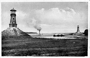
At the spot where the Timiș River flows into the Danube, there are two lighthouses. One is on each bank of the Timiș. These are very rare because most lighthouses are on the coast, not inland on rivers. They are also unique because they were built as a pair. They are located about 3 kilometers (2 miles) from downtown Pančevo.
These lighthouses were built in 1909. This was a time when many steam-powered boats used the rivers. The lighthouses helped guide ships because the river's path had changed. Trees were cut down, making the area unfamiliar to boat crews. This caused accidents, especially at night.
The lighthouses have strong, cone-shaped bases made of stone. The towers are built from yellow bricks. They have decorative frames around their doors and windows. At the top, there is a platform with a powerful light.
The lighthouses became very popular. Ships would honk their horns as they passed them. Young people would visit and climb them as a fun challenge. They even carved their names into the bricks.
Over time, modern ships replaced steamboats. The old port on the Timiș closed in the 1960s, and the lighthouses were no longer used. Parts of them were taken by locals, and the stone bases started to wear away. This made the lighthouses lean and at risk of falling.
In the 21st century, work began to fix the lighthouses. They were fully restored by 2019. Old photos helped with the repairs. The lighthouses are now protected by law as important cultural heritage.
Flooding and Protection
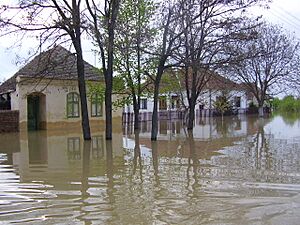
In the Banat region, floods can happen during very rainy years. In 2005, there was a very bad flood. The villages of Boka and Jaša Tomić were badly damaged. On April 20, 2005, the water level reached 844 centimeters (27.7 feet). This was the highest level ever recorded.
To prevent future floods, work began in 2007 to make the riverbanks higher. The embankments (raised banks) were made 30 to 70 centimeters (12 to 28 inches) taller. They are now over 8.5 meters (28 feet) high. This should help stop the river from overflowing.
In some low, marshy areas that were created by floods, several lakes filled with fish have formed. Some of these are near Banatski Despotovac, Uzdin, Sakule, and Slatina.
Rivers Joining the Timiș
Many smaller rivers flow into the Timiș. These are called tributaries.
- From the Left: Brebu, Slatina, Goleț, Bucoșnița, Cerneț, Petroșnița, Valea Mare, Vălișoara, Măcicaș, Vâna Secănească, Vâna Mare, Spaia, Știuca, Cernabora, Timișana, Timișina, Șurgani, Sariș, Pogăniș, Timișul Mort, Lanca Birda, Bârzava/Brzava
- From the Right: Semenic, Teregova, Criva, Pârâul Rece, Feneș, Armeniș, Sadovița, Ilova, Groapa Copaciului, Bolvașnița, Zlagna, Sebeș, Potoc, Bistra, Pleșa, Calova, Maciovița, Vălișor, Tincova, Nădrag, Slatina, Măguri, Tapia, Iarcoș, Timișaț
Towns and Villages Along the Timiș
In Romania
The main cities along the Timiș in Romania are Caransebeș and Lugoj. Other smaller places include:
- Teregova, Armeniș, Slatina-Timiș, Bucoșnița, Buchin, Caransebeș, Constantin Daicoviciu, Sacu, Gavojdia, Lugoj, Coșteiu, Moșnița Nouă, Șag, Parța, Peciu Nou
The city of Timișoara gets its name from the Timiș River. "Timișoara" means "fortress of Timiș." However, Timișoara is not actually on the Timiș River. It is on another river called the Bega.
In Serbia
The towns and villages along the Timiș in Serbia include:
- Jaša Tomić, Šurjan, Boka, Sečanj, Neuzina, Banatski Despotovac, Botoš, Tomaševac, Orlovat, Uzdin, Idvor, Farkaždin, Sakule, Čenta, Baranda, Opovo, Sefkerin, Glogonj, Jabuka, Pančevo
In the early 1700s, after the Austrians took control of the land north of the Sava and Danube rivers, there was an old Ottoman fort at the mouth of the Timiș. In 1716, the Austrians started building a new, larger fortress. It was shaped like a pentagon, with strong brick walls and a bridge over the Timiș. This fortress was similar to the Belgrade Fortress.
The town that grew inside this fortress became the city of Pančevo. In 1739, a peace treaty required Austria to destroy all the new forts. The Pančevo Fortress was torn down, but the town remained. The old streets of Pančevo still follow the shape of where the fortress used to be. In 2013, parts of the old fortress walls were found during park construction.
Pančevo Marsh
The Timiș River used to flow into the Danube about 40 kilometers (25 miles) further north. The area between the old and new river paths and the Danube is called Pančevački Rit, or Pančevo Marsh. This large wetland, about 400 square kilometers (150 square miles), used to flood all the time.
Since World War II, much of the marsh has been drained. Now, almost half of it is very fertile land. It is great for growing grains and vegetables. A large farming company manages this land. It provides food for millions of people in the Belgrade area. Because of this, Pančevački Rit is often called the "Granary of Belgrade." Raising animals, fishing, and hunting are also common here.
Many winding canals and bogs still remain in the marsh. These include slow streams like Vizelj and Dunavac, and large bogs like Reva and Veliko Blato. In the south, there is a river island called Kožara.
Before 1945, very few people lived in Pančevački Rit. But today, many people live there. Some of Belgrade's fastest-growing suburbs, like Borča and Krnjača, are built in this area. The entire Pančevački Rit region is part of Belgrade's Palilula municipality.
Sources
- Mala Prosvetina Enciklopedija, Third edition (1985); Prosveta; ISBN: 86-07-00001-2
- Jovan Đ. Marković (1990): Enciklopedijski geografski leksikon Jugoslavije; Svjetlost-Sarajevo; ISBN: 86-01-02651-6
See also
 In Spanish: Río Timiș para niños
 | William Lucy |
 | Charles Hayes |
 | Cleveland Robinson |


