
Caraș-Severin County facts for kids
Quick facts for kids
Caraș-Severin County
Județul Caraș-Severin
|
||
|---|---|---|
|
County
|
||
 |
||
|
||

Caraș-Severin county, territorial location
|
||
| Country | ||
| Development region1 | Vest | |
| Historic region | Banat | |
| Capital city (Reședință de județ) | Reșița | |
| Government | ||
| • Type | County Council | |
| Area | ||
| • Total | 8,514 km2 (3,287 sq mi) | |
| Area rank | 3rd in Romania | |
| Population
(2021-12-01)
|
||
| • Total | 246,588 | |
| • Rank | 32nd in Romania | |
| • Density | 28.9626/km2 (75.013/sq mi) | |
| Time zone | UTC+2 (EET) | |
| • Summer (DST) | UTC+3 (EEST) | |
| Postal Code |
32wxyz3
|
|
| Area code(s) | +40 x554 | |
| Car Plates | CS5 | |
| GDP | US$3.776 billion (2024) | |
| GDP per capita | US$6,950 (2015) | |
| Website | County Council County Prefecture |
|
| 1The development regions of Romania have no administrative role. They were formed to correspond to NUTS-II level subdivisions of the European Union member states and are the basis for development funding under the cohesion and convergence objectives of the EU's regional policy 2 as of 2007, the Prefect is not a politician, but a public functionary. He (or she) is not allowed to be a member of a political party, and is banned from any political activity in the first six months after resignation (or exclusion) from the public functionary corps 3w, x, y, and z are digits that indicate the city, the street, part of the street, or even the building of the address 4x is a digit indicating the operator: 2 for the former national operator, Romtelecom, and 3 for the other ground telephone networks 5used on both the plates of the vehicles that operate only in the county limits (like utility vehicles, ATVs, etc.), and the ones used outside the county |
||

Caraș-Severin is a county in Romania. It is located on the border with Serbia. Most of the county is in the historical region of Banat. A few villages in the northeast are part of Transylvania. The main city and capital of the county is Reșița. Caraș-Severin is also part of the Danube–Criș–Mureș–Tisa Euroregion.
Contents
What's in a Name?
The county's name is known in several languages. In Serbo-Croatian, it is called Karaš Severin. In Hungarian, it is Krassó-Szörény megye. German speakers know it as Kreis Karasch-Severin. In Bulgarian, it is Karash-Severin.
Exploring the Geography

Caraș-Severin is a large county in Romania. It covers an area of 8,514 square kilometers. This makes it the third largest county in the country. Only Timiș and Suceava counties are bigger. The famous Danube river enters Romania through this county.
Mountains and Hills
Mountains cover most of Caraș-Severin. About 67% of the county's land is mountainous. These include parts of the Southern Carpathians. You can find the Banat Mountains, Țarcu-Godeanu Mountains, and Cernei Mountains here. Their heights range from 600 to 2100 meters. On the western side, there are hills. These hills connect the mountains to the flat Banat Plain.
Rivers and Waterways
The Danube river flows into Romania near Baziaș. It forms a border with Serbia. Other important rivers cross the county. These include the Timiș, Cerna, Caraș, and Nera. Some of these rivers flow through amazing valleys and gorges.
Neighboring Areas
Caraș-Severin shares borders with several other places. To the east, it borders Hunedoara County and Gorj County. Timiș County is to the north. To the southeast, you'll find Mehedinți County. To the southwest, it borders Serbia. This includes the Vojvodina region and the Bor District and Braničevo District.
A Look at History and Economy
The county has a rich history. In 1718, it became part of the Habsburg monarchy. The area was known for its mining industry. In 1771, Reșița became an important industrial center. This happened under Austrian rule.
Later, in 1855, a company called StEG took over the area. They were interested in its mineral deposits and timber. StEG built Romania's oldest railroad track. This line connected Oravița and Baziaș. After World War I, a new company, UDR, took over. The mining industry continued to be very important here.
Fun Things to See and Do
People have lived in this area since ancient times. You can learn about this at the County Museum of History in Reșița. It shows many old artifacts. In Ocna de Fier, there is a special collection of minerals. The county also hosts fun festivals in Spring. These celebrate daffodils and lilacs.
Here are some cool places to visit:
- Cheile Nerei – Beușinta National Park;
- Semenic – Cheile Carașului National Park;
- Domogled – Valea Cernei National Park;
- Danube Iron Gate National Park;
- Semenic resort, a great place for winter sports;
- Băile Herculane resort, known for its thermal baths;
- The Via Transilvanica trail, perfect for hiking and biking.
Who Lives Here?
In 2021, the county had 246,588 people. This means there were about 29 people per square kilometer.
Ethnic composition of Caraș-Severin County (2021) Romanians (91.25%) Romani (2.48%) Croats (2.13%) Serbs (1.59%) Ukrainians (0.70%) Hungarians ({{{value6}}}%) Germans (Banat Swabians) (0.64%) Czechs (0.42%) Others (0.13%)
The table below shows how the population has changed over the years:
| Year | County population |
|---|---|
| 1948 | 302,254 |
| 1956 | |
| 1966 | |
| 1977 | |
| 1992 | |
| 2002 | |
| 2011 | |
| 2021 |
How the County is Organized
Caraș-Severin County is divided into different areas. It has 2 main cities called municipalities. There are also 6 towns and 69 smaller communities called communes.
Main Cities
- Municipalities
- Caransebeș
- Reșița – This is the capital city. About 58,393 people lived here in 2021.
Towns
- Towns
- Anina
- Băile Herculane
- Bocșa
- Moldova Nouă
- Oravița
- Oțelu Roșu
Communes
- Communes
- Armeniș
- Bănia
- Băuțar
- Berliște
- Berzasca
- Berzovia
- Bolvașnița
- Bozovici
- Brebu
- Brebu Nou
- Buchin
- Bucoșnița
- Carașova
- Cărbunari
- Ciclova Română
- Ciuchici
- Ciudanovița
- Constantin Daicoviciu
- Copăcele
- Cornea
- Cornereva
- Coronini
- Dalboșeț
- Doclin
- Dognecea
- Domașnea
- Eftimie Murgu
- Ezeriș
- Fârliug
- Forotic
- Gârnic
- Glimboca
- Goruia
- Grădinari
- Iablanița
- Lăpușnicel
- Lăpușnicu Mare
- Luncavița
- Lupac
- Marga
- Măureni
- Mehadia
- Mehadica
- Naidăș
- Obreja
- Ocna de Fier
- Păltiniș
- Pojejena
- Prigor
- Răcășdia
- Ramna
- Rusca Montană
- Sacu
- Sasca Montană
- Sichevița
- Slatina-Timiș
- Socol
- Șopotu Nou
- Târnova
- Teregova
- Ticvaniu Mare
- Topleț
- Turnu Ruieni
- Văliug
- Vărădia
- Vermeș
- Vrani
- Zăvoi
- Zorlențu Mare
Images for kids
-
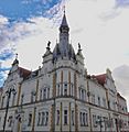
Caransebeș
-
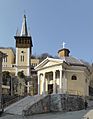
Băile Herculane
-
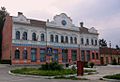
Bocșa
-
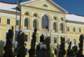
The Caraș-Severin prefecture building from the interwar period.
,_in_departare_Resita_Nord,_1_nov_2008.jpg)


See also
 In Spanish: Distrito de Caraș-Severin para niños
