
Maramureș County facts for kids
Quick facts for kids
Maramureș County
Județul Maramureș
|
|||
|---|---|---|---|
|
(From top to bottom and left to right) Bârsana Monastery, Merry Cemetery, Breb, Maramureș Village Museum, city centre of Sighetu Marmației, Wooden Church of Budești Josani, Wooden Church of Ieud Deal, Wooden Church of Poienile Izei, city centre of Baia Mare
|
|||
|
|||
 |
|||
| Country | Romania | ||
| Development region | Nord-Vest | ||
| Historical region | Maramureș | ||
| Capital | Baia Mare | ||
| Area | |||
| • Total | 6,304 km2 (2,434 sq mi) | ||
| Area rank | 15th | ||
| Population
(2021-12-01)
|
|||
| • Total | 452,475 | ||
| • Rank | 17th | ||
| • Density | 71.776/km2 (185.899/sq mi) | ||
| Telephone code | (+40) 262 or (+40) 362 | ||
| ISO 3166 code | RO-MM | ||
| GDP (nominal) | US$ 6.370 billion (2024) | ||
| GDP per capita | US$ 5,844 (2015) | ||
| Website | County Council Prefecture |
||
.jpg)
_-_IMG_07.jpg)
.JPG)
.jpg)
_-_IMG_05.jpg)

.JPG)
.JPG)


Maramureș County is a special area, or county, in Romania. It is located in the northern part of the country, in a region also called Maramureș. The main city and capital of the county is Baia Mare. This county is known for its beautiful mountains, old traditions, and unique wooden churches.


Contents
Different Names for Maramureș
Maramureș County has different names depending on the language spoken.
- In Hungarian, it is called Máramaros megye.
- In Ukrainian, it is Мараморо́щина.
- In German, it is Kreis Marmarosch.
- In Yiddish, it is מאַרמאַראָש.
Geography of Maramureș County
Maramureș County is in the northern part of Romania. It is part of the historical region of Transylvania. It also shares a border with Ukraine.
Mountains and Rivers
About 43% of the county is covered by the Rodna Mountains. The highest point is Pietrosul, which is 2,303 meters (about 7,556 feet) tall. The Rodna Mountains are part of the Eastern Carpathians, along with the Gutâi and Țibleș ranges. The rest of the county has hills, flat areas, and valleys. The Tisa River flows through the county. Its main smaller rivers are the Iza, Vișeu, and Mara rivers.
Neighboring Areas
Maramureș County is surrounded by several other areas:
- To the east: Suceava County (in Romania).
- To the west: Satu Mare County (in Romania).
- To the north: Ukraine (specifically, the Ivano-Frankivsk and Zakarpattia regions).
- To the south: Sălaj County, Cluj County, and Bistrița-Năsăud County (all in Romania).
Cities and Towns
Maramureș County is divided into different types of areas:
- Municipalities: These are the largest and most important cities.
- Towns: These are smaller than municipalities but still important centers.
- Communes: These are groups of villages, often with a main village.

.JPG)


Main Cities
- Baia Mare: This is the county capital. About 114,925 people lived here in 2011.
- Sighetu Marmației
Towns in Maramureș
- Baia Sprie
- Borșa
- Cavnic
- Dragomirești
- Săliștea de Sus
- Seini
- Șomcuta Mare
- Târgu Lăpuș
- Tăuții-Măgherăuș
- Ulmeni
- Vișeu de Sus
Communes in Maramureș
There are 63 communes in Maramureș County. Some of them include:
- Ardusat
- Băița de sub Codru
- Bârsana
- Budești
- Călinești
- Desești
- Ieud
- Moisei
- Ocna Șugatag
- Poienile Izei
- Săpânța
- Strâmtura
- Vadu Izei
Economy and Traditions
Maramureș is famous for its old traditions related to farming and raising animals. Many tasks like plowing, planting, and harvesting are still done by hand. The county also has a history of mining for metals other than iron. In the past, factories around Baia Mare caused a lot of pollution. However, as industrial activity has decreased, the area has become cleaner.
Tourism in Maramureș

This region is known for its beautiful countryside, traditional wooden crafts, and unique rural buildings. Many roads in the countryside are not paved, but they are usually easy to travel on.
Popular Tourist Spots
- The cities of Baia Mare and Sighetu Marmației.
- The villages along the Iza, Mara, and Vișeu Valleys.
- The famous Wooden churches of Maramureș, which are very old and beautiful.
- The Merry Cemetery of Săpânța, known for its colorful, funny tombstones.
- The Rodna Mountains, which include the Rodna Mountains National Park.
- The Maramureș Mountains Natural Park, a large protected area.
- The scenic area around Cavnic.
- The Memorial of the Victims of Communism and of the Resistance in Sighetu Marmației, a museum about a difficult time in history.
Population of Maramureș
Ethnic composition of Maramureș County (2021) Romanians (84.65%) Ukrainians (including Hutsuls and other Rusyns) (6.36%) Hungarians (5.73%) Romani (2.94%) Germans (Zipser Germans and Transylvanian Saxons) (0.14%) Others (0.19%)
In 2021, the county had a population of 452,475 people. This means there were about 71 people living in each square kilometer (about 184 people per square mile).
Population Changes Over Time
The number of people living in Maramureș County has changed over the years:
| Year | County population |
|---|---|
| 1948 | 321,287 |
| 1956 | 367,114 |
| 1966 | 427,645 |
| 1977 | 492,860 |
| 1992 | 538,534 |
| 2002 | 510,110 |
| 2011 | 461,290 |
| 2021 | 452,475 |
History of Maramureș
The region of Maramureș has a long and interesting history.
- The area was first mentioned in records in 1199.
- In 1241, a big invasion by the Tatars caused a lot of damage and reduced the population by about half.
- In the 14th century, a leader named Bogdan from Maramureș crossed the Carpathian Mountains and helped create the Principality of Moldavia.
- From 1343 to 1402, the Voivodeship of Maramureș existed, led by local Romanian nobles.
- In the Middle Ages, the Maramureș region was well-known for its salt mines and later for its wood.
Changes in Borders
After World War I, in 1920, the northern part of the county became part of a new country called Czechoslovakia. The southern part, including Sighetu Marmației, became part of the Kingdom of Romania.
Later, in 1940, during World War II, parts of the county were given back to Hungary for a few years. However, in 1944, Romanian and Soviet forces took the land back, and it became part of Romania again. The current county system in Romania, including Maramureș, was re-established in 1968.
Famous People from Maramureș
Many notable people were born in or are from Maramureș County. Some of them include:
- Augustin Buzura
- Ștefan Hrușcă
- Gheorghe Pop de Băsești
- Paula Seling
- Elie Wiesel
Images for kids
-
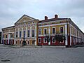
The Maramureș County Prefect's building from the interwar period.
-
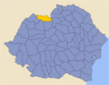
Map of Maramureș County as it was in 1938.
-
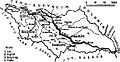
Map of Maramureș County as constituted in 1938.
.JPG)


See also
 In Spanish: Distrito de Maramureș para niños
