Dâmbovița County facts for kids
Quick facts for kids
Dâmbovița County
Județul Dâmbovița
|
||
|---|---|---|
|
County
|
||
Leaota Mountains
|
||
|
||
 |
||
| Country | ||
| Development region1 | Sud | |
| Historic region | Muntenia | |
| Capital city (Reședință de județ) | Târgoviște | |
| Government | ||
| • Type | County Council | |
| Area | ||
| • Total | 4,054 km2 (1,565 sq mi) | |
| Area rank | 37th in Romania | |
| Population
(2021-12-01)
|
||
| • Total | 479,404 | |
| • Rank | 15th in Romania | |
| • Density | 118.255/km2 (306.28/sq mi) | |
| Time zone | UTC+2 (EET) | |
| • Summer (DST) | UTC+3 (EEST) | |
| Postal Code |
13wxyz3
|
|
| Area code(s) | +40 x454 | |
| Car Plates | DB5 | |
| GDP | US$3.153 billion (2015) | |
| GDP per capita | US$6,078 (2015) | |
| Website | County Board County Prefecture |
|
| 1The development regions of Romania have no administrative role. They were formed just to attract funds from the European Union 2 as of 2007, the Prefect is not a politician, but a public functionary. He (or she) is not allowed to be a member of a political party, and is banned to have any political activity in the first six months after the resignation (or exclusion) from the public functionary corps 3w, x, y, and z are digits that indicate the city, the street, part of the street, or even the building of the address 4x is a digit indicating the operator: 2 for the former national operator, Romtelecom, and 3 for the other ground telephone networks 5used on both the plates of the vehicles that operate only in the county limits (like utility vehicles, ATVs, etc.), and the ones used outside the county |
||
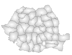
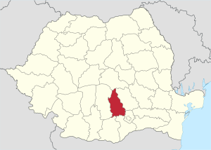
Dâmbovița County is a region in Romania. It's located in the south-central part of the country, in an area called Muntenia. The main city and capital of Dâmbovița County is Târgoviște. This city is super important for the county's economy, government, and culture. Dâmbovița has been an official administrative area since way back in 1512!
Contents
What's in a Name?
The county gets its name from the Dâmbovița River. This name comes from a Slavic word, dâmb, which means "oak". The river used to flow through many oak forests in the Wallachian Plain.
Geography and Landscape
Dâmbovița County covers an area of 4,054 square kilometers. That's about 1.7% of Romania's total land! It's located in the south-central part of the country. The county sits in the river basins of the Ialomița and Dâmbovița rivers.
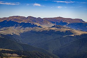
The highest point in the county is Omu Peak, which is 2,505 meters high. You can find it in the Bucegi Mountains. The lowest parts are around 120–125 meters high, in the Titu Plain.
Neighboring Counties
Dâmbovița County shares borders with several other counties:
- To the North: Brașov County
- To the East: Prahova County
- To the South-East: Ilfov County
- To the South: Teleorman County and Giurgiu County
- To the West: Argeș County
People and Population
In 2021, Dâmbovița County had about 479,404 people living there. This means it's one of the most crowded counties in Romania. About 120 people live in every square kilometer.
Most of the people living here are Romanians, making up about 87.09% of the population. Other groups include Roma (3.96%), Bulgarians (0.31%), and Serbians (0.1%).
| Year | County population |
|---|---|
| 1948 | 409,272 |
| 1956 | 438,985 |
| 1966 | 453,241 |
| 1977 | 527,620 |
| 1992 | 559,874 |
| 2002 | 541,763 |
| 2011 | 518,745 |
| 2021 | 479,404 |
Economy and Industries
Dâmbovița County is an important place for industry in Romania. One of the largest steel factories in the country is located in Târgoviște. Also, oil is found and processed here.
The main types of industries in the county are:
- Making metal products (metallurgical industry).
- Building equipment for oil extraction.
- Producing food.
- Making home appliances.
- Creating textiles (like clothes and fabrics).
- Chemical production.
- Making construction materials.
Fun Places to Visit
Dâmbovița County has many cool places to explore:
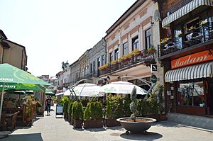
- The city of Târgoviște was once the old capital of Muntenia. It has lots of history!
- The Pucioasa Resort is a great place to relax.
- The Ialomița River Valley is full of holiday spots, places to camp, waterfalls, and amazing nature reserves.
- You can also see the famous rock formations called Babele and the Bucegi Sphinx.
Cool Facts and Trivia
- A small village in this area called Glod was used to pretend to be Kazakhstan in the movie Borat: Cultural Learnings of America for Make Benefit Glorious Nation of Kazakhstan.
- The capital city, Târgoviște, was where Vlad the Impaler lived. He was the real person who inspired the famous Bram Stoker character, Dracula.
How the County is Organized
Dâmbovița County is divided into different types of areas. It has 2 municipalities, 5 towns, and 82 communes. These areas include 361 villages.
Main Cities
- Municipalities:
- Moreni
- Târgoviște – This is the county's capital city, with about 79,610 people (as of 2011).
- Towns:
- Fieni
- Găești
- Pucioasa
- Răcari
- Titu
Communes
- Aninoasa
- Băleni
- Bărbulețu
- Bezdead
- Bilciurești
- Braniștea
- Brănești
- Brezoaele
- Buciumeni
- Bucșani
- Butimanu
- Cândești
- Ciocănești
- Cobia
- Cojasca
- Comișani
- Conțești
- Corbii Mari
- Cornățelu
- Cornești
- Costeștii din Vale
- Crângurile
- Crevedia
- Dărmănești
- Dobra
- Doicești
- Dragodana
- Dragomirești
- Finta
- Glodeni
- Gura Foii
- Gura Ocniței
- Gura Șuții
- Hulubești
- I. L. Caragiale
- Iedera
- Lucieni
- Ludești
- Lungulețu
- Malu cu Flori
- Mănești
- Mătăsaru
- Mogoșani
- Moroeni
- Morteni
- Moțăieni
- Niculești
- Nucet
- Ocnița
- Odobești
- Perșinari
- Pietrari
- Petrești
- Pietroșița
- Poiana
- Potlogi
- Produlești
- Pucheni
- Raciu
- Răscăeți
- Răzvad
- Râu Alb
- Runcu
- Sălcioara
- Slobozia Moară
- Șelaru, Dâmbovița
- Șotânga
- Tărtășești
- Tătărani
- Uliești
- Ulmi
- Văcărești
- Valea Lungă
- Valea Mare
- Văleni-Dâmbovița
- Vârfuri
- Vișina
- Vișinești
- Vlădeni
- Voinești
- Vulcana-Băi
- Vulcana-Pandele
Dâmbovița in the Past
|
Județul Dâmbovița
|
||
|---|---|---|
|
County (Județ)
|
||
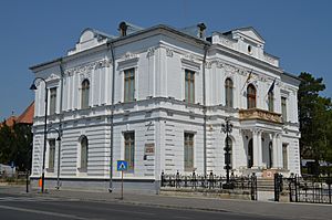
The Dâmbovița County prefecture building from the interwar period, now an art museum.
|
||
|
||
 |
||
| Country | ||
| Historic region | Muntenia | |
| Capital city (Reședință de județ) | Târgoviște | |
| Area | ||
| • Total | 3,440 km2 (1,330 sq mi) | |
| Population
(1930)
|
||
| • Total | 310,310 | |
| • Density | 90.21/km2 (233.6/sq mi) | |
| Time zone | UTC+2 (EET) | |
| • Summer (DST) | UTC+3 (EEST) | |
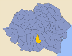
Long ago, Dâmbovița was a county in a bigger country called Greater Romania. It was in the northern part of the historical region of Muntenia. The county's borders were a bit different back then. Its capital city was also Târgoviște.
Old Divisions
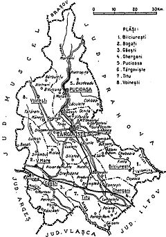
The county used to be split into smaller areas called districts (plăși). At first, there were six of these districts. Later, the county was reorganized into eight districts. This shows how administrative areas can change over time!
Population in 1930
In 1930, about 309,676 people lived in the county. Most of them (96.9%) were Romanians. There were also smaller groups of Romanies, Jews, Hungarians, and Germans. Most people followed the Eastern Orthodox religion.
See also
 In Spanish: Distrito de Dâmbovița para niños
 | Jewel Prestage |
 | Ella Baker |
 | Fannie Lou Hamer |


