Toomsuba, Mississippi facts for kids
Quick facts for kids
Toomsuba, Mississippi
|
|
|---|---|

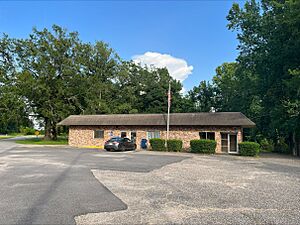
Toomsuba Post Office
|
|
| Country | United States |
| State | Mississippi |
| County | Lauderdale |
| Area | |
| • Total | 5.00 sq mi (12.96 km2) |
| • Land | 4.69 sq mi (12.14 km2) |
| • Water | 0.31 sq mi (0.81 km2) |
| Elevation | 302 ft (92 m) |
| Population
(2020)
|
|
| • Total | 778 |
| • Density | 165.92/sq mi (64.06/km2) |
| Time zone | UTC-6 (Central (CST)) |
| • Summer (DST) | UTC-5 (CDT) |
| ZIP code |
39364
|
| Area code(s) | 601 & 769 |
| GNIS feature ID | 678818 |
| FIPS code | 28-73880 |
Toomsuba is a small community located in Lauderdale County, Mississippi, in the United States. It is known as a census-designated place (CDP). This means it's an area that the U.S. Census Bureau defines for collecting population statistics, but it doesn't have its own official city government. In 2020, about 778 people lived in Toomsuba. The community's name comes from a nearby stream called Toomsuba Creek. Its ZIP code is 39364.
Contents
Where is Toomsuba Located?
Toomsuba is in the eastern part of Lauderdale County, Mississippi. It is about 13 miles (21 kilometers) east of Meridian, which is the main city and county seat for the county.
Roads and Highways
Major roads like U.S. Routes 80 and 11 run through Toomsuba and act as its main street. Interstate Highways 20 and 59 are just south of the community. You can get to Toomsuba from Exit 165 (Will Garrett Road) on these interstates.
Interstate 20 and Interstate 59 go west towards Meridian. They also head northeast about 77 miles (124 kilometers) to Tuscaloosa, Alabama. U.S. Routes 11 and 80 also go west to Meridian. Eastward, they travel about 9 miles (14 kilometers) before splitting near Cuba, Alabama.
Toomsuba's Size and Water Areas
According to the U.S. Census Bureau, the Toomsuba CDP covers a total area of about 5.0 square miles (13.0 square kilometers). Most of this area, about 4.7 square miles (12.1 square kilometers), is land. The rest, about 0.3 square miles (0.8 square kilometers), is water. This means about 6.27% of Toomsuba's area is water.
The community includes the main center where U.S. Routes 11/80 meet Will Garrett Road and Lauderdale–Toomsuba Road. It also has homes built around Bailey Lake, which is a reservoir located just west of the town center.
Who Lives in Toomsuba?
This section shares information about the people living in Toomsuba. The numbers come from the 2020 United States census, which is a count of everyone living in the U.S. done every ten years.
Population Count
| Historical population | |||
|---|---|---|---|
| Census | Pop. | %± | |
| 2020 | 778 | — | |
| U.S. Decennial Census | |||
As of the 2020 census, there were 778 people living in Toomsuba. These people made up 300 households, and 194 of these households were families.
Diversity in Toomsuba
The table below shows the different racial groups that make up Toomsuba's population, based on the 2020 census. "NH" means "Non-Hispanic," which helps to show different ethnic backgrounds.
| Race | Number of People | Percentage of Total |
|---|---|---|
| White (NH) | 432 | 55.53% |
| Black or African American (NH) | 305 | 39.2% |
| Some Other Race (NH) | 2 | 0.26% |
| Mixed/Multi-Racial (NH) | 20 | 2.57% |
| Hispanic or Latino | 19 | 2.44% |
| Total | 778 |
Famous People from Toomsuba
Toomsuba has been home to a few notable individuals:
- Norman Robinson was a well-known journalist from New Orleans.
- Jack Spinks was a professional football player who played as a fullback in the National Football League. A stadium, Casem-Spinks Stadium, which is the home field for the Alcorn State Braves football team, is partly named after him.
- Richard E. Thompson served as a member of the Mississippi State Senate, which is part of the state's government, from 1916 to 1920.
- John A. Yeager was a member of the Mississippi House of Representatives, another part of the state's government, from 1916 to 1932.
See also
 In Spanish: Toomsuba para niños
 | Selma Burke |
 | Pauline Powell Burns |
 | Frederick J. Brown |
 | Robert Blackburn |


