Tortue River facts for kids
Quick facts for kids Tortue River |
|
|---|---|

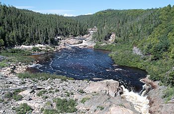
The river near its mouth, looking north from Quebec Route 138
|
|
| Other name(s) | Rivière Tortue |
| Country | Canada |
| Province | Quebec |
| Region | Côte-Nord |
| RCM | Minganie Sept-Rivières Regional County Municipality |
| Physical characteristics | |
| Main source | Lake Tortue Rivière-Nipissis 620 m (2,030 ft) 50°55′29″N 65°30′22″W / 50.924719°N 65.506111°W |
| River mouth | Gulf of Saint Lawrence Rivière-au-Tonnerre 0 metres (0 ft) 50°18′03″N 65°22′27″W / 50.300833°N 65.374167°W |
| Length | 79.4 km (49.3 mi) |
| Basin features | |
| Basin size | 793 square kilometres (306 sq mi) |
| Tributaries |
|
| Bridges | Route 138 |
The Tortue River, also known as the Turtle River (French: Rivière Tortue), is a river in the Quebec province of Canada. It flows through the Côte-Nord region. The river starts in an unorganized territory called Rivière-Nipissis. Then it flows into the Minganie area, passing through Lac-Jérôme and the town of Rivière-au-Tonnerre. Finally, it empties into the Gulf of Saint Lawrence.
A major road, Quebec Route 138, runs along the northern shore of the estuary of Saint Lawrence. This road also serves the southern part of the Tortue River area.
Contents
River's Journey
The Tortue River begins at Turtle Lake. This lake is shaped like an octopus and is about 3.5 km (2.2 mi) long. It sits at an altitude of 620 m (2,030 ft). The lake gets its water from several smaller lakes and streams around it.
From Turtle Lake, the river flows for about 79.4 km (49.3 mi) towards the south. During its journey, the river drops about 620 m (2,030 ft) in elevation.
Upper River Course
The first part of the river's journey covers about 27.3 km (17.0 mi).
- It flows south, going through a small lake.
- Then it turns southwest and later south, passing through Lake Eliniore. This lake is about 1.7 km (1.1 mi) long.
- After Lake Eliniore, the river flows southeast through a deep valley. It makes a sharp turn south before meeting the rivière aux Îlets.
Lower River Course
The next section of the river is about 21.6 km (13.4 mi) long.
- It first flows south, then curves east.
- It continues south, then southeast, meeting the rivière aux Chutes.
- The river then flows southwest for about 10.0 km (6.2 mi), forming some smaller channels. It then meets the Petite rivière Tortue.
Final Stretch
The last part of the Tortue River's journey is about 30.5 km (19.0 mi).
- It flows southeast, making a few turns and collecting water from Lake Fabien.
- It also picks up water from the Philippe-Henley stream.
- Finally, it continues southeast, collecting water from five more streams. It passes under the Quebec Route 138 bridge before reaching its mouth.
The river ends in the town of Rivière-au-Tonnerre. A metal bridge on Quebec Route 138 crosses the river close to where it meets the Gulf of St. Lawrence.
River's Name
The name "Tortue River" means "Turtle River" in English. No one knows for sure how the river got its name. The name was officially recognized on December 5, 1968.
Some places nearby are named after early European settlers. For example, there's Moïse Maher Lake and the Ruisseau Philippe Henley, which is a stream that flows into the Tortue River.
River Basin
The area of land that drains into the Tortue River is called its basin. This basin covers about 793 square kilometres (306 sq mi).
- Part of the river basin is in the unorganized territories of Rivière-Nipissis and Lac-Jérôme.
- Another part is within the municipality of Rivière-au-Tonnerre.
The Tortue River basin is located between two other river basins: the Sault Plat River basin to the west and the Manitou River basin to the east. The area is known for its spruce trees and moss, typical of the eastern spruce/moss subdomain in Quebec's ecological regions.
 | Percy Lavon Julian |
 | Katherine Johnson |
 | George Washington Carver |
 | Annie Easley |


