
Totonicapán facts for kids
Quick facts for kids
Totonicapán
|
|
|---|---|
|
Municipality
|
|

Central park of Totonicapán
|
|
| Nickname(s):
Toto
|
|

Municipality of Totonicapán within the Department of Totonicapán
|
|

Totonicapán
Location in Guatemala
|
|
| Country | |
| Department | |
| Government | |
| • Type | Municipal |
| Area | |
| • Municipality | 274 km2 (106 sq mi) |
| Elevation | 2,495 m (8,186 ft) |
| Population
(2018 census)
|
|
| • Municipality | 103,952 |
| • Density | 379.4/km2 (982.6/sq mi) |
| • Urban | 103,952 |
| • Ethnicities | K'iche' people Ladino |
| • Religions | Roman Catholicism Evangelicalism Maya |
| Climate | Cwb |
Totonicapán is a city in Guatemala. It is the main city of the Totonicapán department. It also serves as the center for the area around it, called the Municipality of Totonicapán.
Contents
History of Totonicapán
Early History and Independence
In 1838, Totonicapán became an independent republic. This new state included the nearby areas of Sololá and Quezaltenango. However, this independent state only lasted for two years. After that, it rejoined the country of Guatemala.
Major Events in Totonicapán
Totonicapán faced a big challenge during the earthquake of April 18, 1902. The city was greatly affected by this natural disaster.
In the past, Totonicapán was also well-known for its hot springs. These are places where warm water comes up from underground.
Images for kids
-
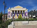
The Municipal Theater of Totonicapán
-
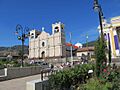
The central plaza in Totonicapán
-
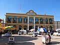
The municipal building of Totonicapán


See also
 In Spanish: Totonicapán (municipio) para niños
