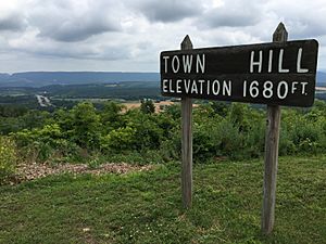
Town Hill facts for kids
Town Hill is a cool mountain range that stretches across parts of Allegany County, Maryland and Bedford and Fulton Counties in Pennsylvania. It starts near Kiefer, Maryland, and goes northeast, ending close to Emmaville, Pennsylvania. The highest point of Town Hill reaches about 2,000 feet!
Did you know that a major highway, Interstate 70, actually crosses Town Hill? It follows the top of the mountain for several miles. In Maryland, another big road, Interstate 68, runs along the southern edge of the mountain. The old U.S. Route 40, which is now called U.S. Route 40 Scenic, also goes right over Town Hill.
A part of the beautiful Buchanan State Forest is located on Town Hill in Fulton County, Pennsylvania. South of the Potomac River, in Hampshire County, West Virginia, Town Hill rises to a height of about 1,306 feet.
What is Town Hill Made Of? (Geology)
Mountains like Town Hill are formed over millions of years! Town Hill is mostly made of a type of rock called the Pocono Formation. This rock formed during a time period called the Mississippian Age. The layers of this rock are tilted, or "dip," towards the northwest.
Below the Pocono Formation, on the southeast side of the mountain, you can find older rocks. These include the Rockwell Formation and the Catskill Formation. These rocks formed even earlier, during the Devonian period. Town Hill and another nearby mountain called Rays Hill actually form a "syncline." This is a geological term for a fold in rock layers that looks like a U-shape or a trough. Imagine a giant blanket that has been pushed together to make a dip!
 | Calvin Brent |
 | Walter T. Bailey |
 | Martha Cassell Thompson |
 | Alberta Jeannette Cassell |


