Towradgi, New South Wales facts for kids
Quick facts for kids TowradgiWollongong, New South Wales |
|||||||||||||||
|---|---|---|---|---|---|---|---|---|---|---|---|---|---|---|---|

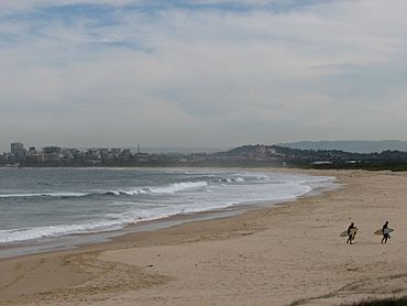
Towradgi Beach, looking south to Wollongong
|
|||||||||||||||
| Population | 3,127 (2016 census) | ||||||||||||||
| Postcode(s) | 2518 | ||||||||||||||
| Elevation | 15 m (49 ft) | ||||||||||||||
| Location |
|
||||||||||||||
| LGA(s) | City of Wollongong | ||||||||||||||
| State electorate(s) | Wollongong | ||||||||||||||
| Federal Division(s) | Cunningham | ||||||||||||||
|
|||||||||||||||
Towradgi (pronounced like tow-RAD-jee) is a small suburb located right by the beach. It's about 5 kilometers (3 miles) north of Wollongong, New South Wales, in Australia. The name Towradgi comes from the Dharawal word Kow-radgi, which means "guardian of the sacred stones." Long ago, on some old maps, it was even called Towroger.
Towradgi is surrounded by other towns. To the north is Corrimal, and to the west are Fernhill and Tarrawanna. To the south, you'll find Fairy Meadow. The big Pacific Ocean is right there to the east! Towradgi also includes parts of an older area called Reidtown.
Contents
What Can You Do in Towradgi?
Towradgi has many cool places and activities for everyone. It's a great spot for families and visitors.
Fun Places and Services
You can find a surf club here, perfect for those who love the waves. There's also a bowling and recreation club where you can have fun with friends. If you're hungry, there's a Chinese restaurant.
Other helpful places include:
- A croquet club for a different kind of sport.
- Two petrol stations.
- A hairdresser.
- A retirement village.
- Towradgi Public School for students.
- A train station, which opened in 1948.
- Many open parks for playing and relaxing.
- A rock pool, which is a natural swimming area by the ocean.
The Famous "Hump" Bridge
One of Towradgi's well-known landmarks is a small bridge on Towradgi Road. This bridge goes over the train tracks near Towradgi station. People in the area often call it "the hump." It's known for its short, steep rise. Sometimes, if cars go over it too fast, they might even feel like they're flying a little!
Exploring Towradgi Point and the Coast
East of Towradgi, you'll find Towradgi Point. This is a rocky area that sticks out into the ocean. The Towradgi rockpool is right at the very tip of this point.
Towradgi Creek and Shipwrecks
North of the point is where Towradgi Creek meets the ocean. A short distance out to sea from here is a famous shipwreck site. The ship, called the Queen of Nations, was wrecked in the 1880s. You can sometimes see a dark blur in the water at low tide, marking its spot.
A plaque at the point tells the sad story of the wreck. The ship's captain, Samuel Bache, made a mistake on May 31, 1881. He thought fires from a coal mine were a lighthouse in Sydney, and he crashed his ship. The ship was carrying alcohol when it sank. Today, it's a protected wreck site, meaning it's kept safe underwater.
Amazing Views and Bike Paths
Many people visit Towradgi Point to enjoy the beautiful views. You can see Wollongong to the south and places like Corrimal, Bellambi Point, and the northern escarpment to the north. You can also spot Sublime Point and the southern mountains from the park.
A bridge across the creek was rebuilt in 2006. It's used by people who love to cycle and walk. Here, the Wollongong to Thirroul Bike Track splits into two separate paths. The point also has a park and a picnic area, making it a popular spot for surfing and swimming.
A Historic Landing Spot
South of the point, on the beach, is a special historical site. This is where George Bass and Matthew Flinders, along with their helper Martin, tried to land their small boat, the Tom Thumb. On March 21, 1796, the sea pulled their boat out and filled it with water! They managed to bail it out and keep going after collecting water from Towradgi Creek. A plaque remembers this event.
Beach Erosion
In June 2007, big storms caused some damage to the beach and its entrance paths. However, areas with lots of plants held up well against the erosion.
| Weather chart for Towradgi | |||||||||||||||||||||||||||||||||||||||||||||||
|---|---|---|---|---|---|---|---|---|---|---|---|---|---|---|---|---|---|---|---|---|---|---|---|---|---|---|---|---|---|---|---|---|---|---|---|---|---|---|---|---|---|---|---|---|---|---|---|
| J | F | M | A | M | J | J | A | S | O | N | D | ||||||||||||||||||||||||||||||||||||
|
83
25
19
|
83
25
19
|
133
24
18
|
119
22
16
|
86
20
13
|
130
18
11
|
81
17
10
|
98
18
11
|
67
20
13
|
76
22
14
|
103
22
16
|
77
24
18
|
||||||||||||||||||||||||||||||||||||
| temperatures in °C precipitation totals in mm source: Australian Meteorology |
|||||||||||||||||||||||||||||||||||||||||||||||
|
Imperial conversion
|
|||||||||||||||||||||||||||||||||||||||||||||||
History of Towradgi
The name Towradgi comes from a Dharawal word. It means the guardian of the sacred stones. Old maps show it was first known as Towroger, according to a book called Henderson's Early Illawarra.
First European Landing
On March 26, 1796, just south of Towradgi Point, George Bass and Matthew Flinders tried to land on the coast. They were with their young helper, Martin. At this time, they became the first European settlers to step onto the land of Illawarra.
Railway Arrives
In 1887, the South Coast railway line reached Towradgi. Later, on December 18, 1948, the Towradgi railway station officially opened. This made it easier for people to travel to and from Towradgi by train.
 | Georgia Louise Harris Brown |
 | Julian Abele |
 | Norma Merrick Sklarek |
 | William Sidney Pittman |


