Tozeur Governorate facts for kids
Quick facts for kids
Tozeur
توزر
|
|
|---|---|

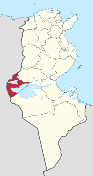
Map of Tunisia with Tozeur highlighted
|
|
| Country | Tunisia |
| Created | June 21, 1956 |
| Capital | Tozeur |
| Area | |
| • Total | 4,719 km2 (1,822 sq mi) |
| Area rank | Ranked 11th of 24 |
| Population
(2014)
|
|
| • Total | 107,912 |
| • Rank | Ranked 24th of 24 |
| • Density | 22.8676/km2 (59.227/sq mi) |
| Time zone | UTC+01 (CET) |
| Postal prefix |
xx
|
| ISO 3166 code | TN-72 |
The Tozeur Governorate (which is Wilāyat Tauzar in Arabic) is a region in Tunisia, a country in North Africa. It's located in the western part of Tunisia, right next to the border with Algeria. This area covers about 4,719 square kilometers.
In 2014, around 107,912 people lived here. This makes Tozeur the smallest governorate in Tunisia when it comes to how many people live there. The main city and capital of this region is also called Tozeur.
Contents
Geography and Landscape
The Tozeur Governorate is known for its unique desert landscape. A large part of the area is covered by a huge salt lake called the Chott el Djerid. This salt flat stretches across several governorates.
The Chott el Djerid
The Chott el Djerid is a very large, dry salt lake. It looks like a vast, flat, white plain. Most of this salt flat is in the Kebili Governorate. A smaller part extends into the Tozeur region.
This area can get very hot and dry. The salt flats are often shimmering in the heat. Sometimes, you can even see mirages, which are optical illusions that make it look like there's water in the distance.
Population and Life
Even though it's a desert region, people have lived in Tozeur for a very long time. They have adapted to the climate. The main city of Tozeur is a lively place.
How People Live
Life in Tozeur often revolves around the date palm oases. These are green areas where water is available. Date palms provide food and shade. People also work in tourism, as many visitors come to see the unique desert scenery.
History of the Governorate
The Tozeur Governorate was officially created on June 21, 1956. This was after Tunisia gained its independence. Before that, the area had a long history. It was an important stop for trade routes across the Sahara Desert.
Ancient Times
In ancient times, Tozeur was a key point for caravans. These caravans carried goods like salt and gold. The region was part of different empires over the centuries. These included Roman and Arab empires.
Images for kids
-
The Chott el Djerid occupies a large amount of the area with a larger part in Kebili and a small fraction in coastal Gabes province
See also
 In Spanish: Gobernación de Tozeur para niños
 | Janet Taylor Pickett |
 | Synthia Saint James |
 | Howardena Pindell |
 | Faith Ringgold |


