
Trabboch Castle facts for kids
Quick facts for kids Trabboch Castle |
|
|---|---|
| Stair, east Ayrshire, Scotland | |

Trabboch Castle
|
|
| Coordinates | 55°28′06″N 4°26′27″W / 55.4684°N 4.4408°W |
| Site information | |
| Owner | Trabboch Mains Farm |
| Controlled by | Boyd clan |
| Open to the public |
No |
| Condition | Ruined |
| Site history | |
| Built | 14th century |
| Materials | Stone |
Trabboch Castle is an old, ruined castle in Scotland. It's located in a place called Stair, in East Ayrshire. This castle used to be an 'L-plan' tower house, which means it was shaped like the letter L. It was once a strong home for important families.
Contents
What is the History of Trabboch Castle?
Who Owned Trabboch Castle?
The area around Trabboch Castle was first mentioned in records around 1303-1304. King Robert the Bruce gave this castle to the Boyd family of Kilmarnock. He gave it to them because they helped him during the Battle of Bannockburn in 1314.
Later, in 1469, the Boyd family lost the castle. It was taken by the King and was supposedly used by the King's oldest sons. By 1451, the Douglas family owned the land, and then it went to the Boswells of Auchinleck.
In the 1600s, other families like the Chalmers of Gadgirth and Reid of Barskimming owned parts of the Trabboch area. The Arthurs, Lord Ochiltree, and the Campbells of Loudoun also owned Trabboch Castle at different times.
What Was the Castle Like?

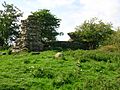
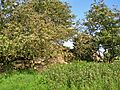
In 1954, what was left of Trabboch Castle was an L-shaped part of a wall. It didn't have any windows or doors that could be seen. The walls were very thick, about 2.5 meters (8 feet) wide. They were built from large, rough stones.
The longest part of the wall was about 12.5 meters (41 feet) long. There was a wide natural ditch on one side. A shallow ditch on another side might have been part of the castle's defenses.
Much of the castle's stone was later used to build the nearby Trabboch Mains Farm. Today, the castle ruins are protected as a scheduled monument. This means they are important historical sites that must be preserved.
Historians believe Trabboch Castle was part of a line of castles. These castles helped protect the area called Kyle Regis. Other castles in this defensive chain included Stair, Auchencloigh, Drongan, and Drumsuie.
A grave was found near the castle site. It was cut into red sandstone and covered by a flat stone. Inside, there were some beads and dark dust.
How Do Old Maps Show Trabboch Castle?
Old maps help us see where Trabboch Castle was located.
- Gordon's map from 1636-1652 shows Trabboch Castle.
- Roy's map from 1747 marks both "Trabog" and "Lawhill."
- Molls map from 1745 also shows the castle.
- John Thomson's map from 1828 clearly marks "Traboch Castle."

What About the Loch of Trabboch?
The old Loch of Trabboch was a lake where many birds lived. Swans, moor hens, and other water birds nested there. The laird, or lord, of Trabboch used this area for hunting and fishing. The current Trabboch Loch was formed in the 1800s when a coal mine called Drumdow pit flooded.
Images for kids
-
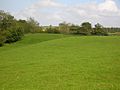
Trabboch Castle site and earthworks
-
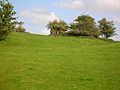
The castle ruins from the west
-
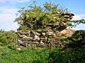
Details of the castle walls
-
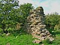
A south facing wall
-
Castle ruins from the east
-
The view of the castle from the south-west


