
Loch of Trabboch facts for kids
Quick facts for kids The Loch of Trabboch or Dalrympleston Loch |
|
|---|---|

The site of the Loch of Trabboch
|
|
| Lua error in Module:Location_map at line 420: attempt to index field 'wikibase' (a nil value). | |
| Location | Trabboch, East Ayrshire, Scotland |
| Type | Drained freshwater loch |
| Primary inflows | Dalrympleston Burn |
| Primary outflows | Dalrympleston Burn |
| Basin countries | Scotland |
| Max. length | c. 680 ft (210 m) |
| Max. width | c. 350 ft (110 m) |
| Average depth | Shallow |
| Islands | One |
| Settlements | Drongan |
The Loch of Trabboch, also known as Dalrympleston Loch, was a lake in East Ayrshire, Scotland. It was located in a low area near the old Trabboch Castle. This castle was once owned by the Boyd family. The loch is no longer there today.
Contents
History of the Loch of Trabboch
The Loch of Trabboch was first written about in 1654. People pronounced its name "Traaboch". Early maps show that the loch had a small, comma-shaped island. This island was about 120 feet (40 metres) long.
Around 1905, a nearby coal mine called Drumdow colliery closed. It then filled with water and became known as Trabboch Loch. Because of this, the original Loch of Trabboch site became known as Dalrympleston Loch or marsh.
What Was the Loch Used For?
The Loch of Trabboch was a home for many birds. Swans, moor hens, and other water birds nested there. The local lord used the area for hunting and fishing. It was part of the old Trabboch Barony.
The loch was also a popular place for curling. Curling is a sport played on ice. Records show that from 1853 to the 1880s, curling clubs used the loch. Clubs from places like Tarbolton and Ochiltree played matches there.
How Maps Showed the Loch
Old maps help us understand how the loch changed over time.
- 1654 Map: A map by Blaeu from 1654 clearly shows and names the loch. It shows water flowing out towards the Water of Coyle.
- 1747 and 1832 Maps: Roy's map from 1747 and Thomson's map from 1832 do not show the loch at all. This might mean it was sometimes dry or not considered important enough to draw.
- 19th Century Maps: The Ordnance Survey maps from the 1800s show the loch clearly. They show the island and water flowing in from the Dalrympleston Burn. This water then flowed to the Water of Coyle. These maps also show a large wet area around the loch.
- Later Maps: By 1897, the Ordnance Survey map marked the loch as a "Curling Pond". However, the 1948 map shows a drain running through the loch. It no longer mentions curling. Many drainage projects happened after World War I. After 1959, the loch became a wetland. It no longer had open water.

Interesting Facts About the Area
Trabboch Castle's Story
The land where Trabboch Castle stands was first mentioned in 1303-1304. King Robert the Bruce gave the castle to the Boyd family. This was a reward for their help at the Battle of Bannockburn. Later, the castle belonged to the Earl of Douglas and then the Boswells of Auchinleck. Other families, like the Chalmers and Reid families, also owned parts of the area. The Arthurs and Campbells also held Trabboch Castle at different times.
Trabboch Castle was part of a line of castles in the area. These castles helped defend the region. Other castles in this defensive chain included Stair, Auchencloigh, Drongan, and Drumsuie.
Local Wildlife
In 1987, a rare bird called a Common Crane was seen at the Dalrympleston marsh. This area is known as a good spot for watching birds.
Images for kids
-
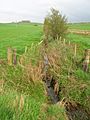
The Dalrympleston Burn running down towards the old loch site.
-
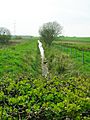
The drain and loch site looking towards the Water of Coyle.
-
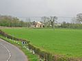
Dalrympleston Farm from the loch site.
-
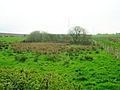
Willows on the site of the old loch island.


