Trampas Canyon facts for kids
Quick facts for kids Trampas Canyon Creek |
|
|---|---|

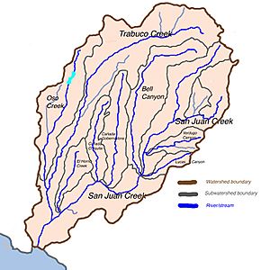
Stream map of San Juan Creek watershed with three major tributaries in dark blue, smaller streams in light blue, and cities and towns in orange. Trampas Canyon Creek is the short waterway flowing north into San Juan Creek, near the lower edge of the map.
|
|
| Country | United States |
| State | California |
| District | Orange County |
| Physical characteristics | |
| Main source | Trampas Canyon Reservoir near Santa Ana Mountains 800 ft (240 m) 33°29′18″N 117°35′36″W / 33.4883597°N 117.5933813°W |
| River mouth | San Juan Creek 272 ft (83 m) 33°30′53″N 117°34′58″W / 33.5147478°N 117.5828254°W |
| Length | 0.8 mi (1.3 km) |
| Basin features | |
| River system | San Juan Creek |
Trampas Canyon Creek is a small stream in southern Orange County, California, in the United States. It is a "tributary," which means it flows into a larger stream called San Juan Creek.
Contents
Where Trampas Canyon Creek Starts
Trampas Canyon Creek begins high up in the southern Santa Ana Mountains. It starts from different branches on the steep slopes of these mountains.
How the Creek Flows
The creek flows north from its starting point. It then reaches a place where it is held back by the Trampas Canyon Dam. This dam creates a small lake. This lake has four branches that spread out. After the water leaves the dam, the creek continues to flow north. It then turns a little to the west. Finally, it joins San Juan Creek.
When the Creek Flows
Trampas Canyon Creek is an "ephemeral" stream. This means it does not flow all the time. It only has water during big rainstorms. It also flows when water is released from the Trampas Canyon Dam. It is not one of the main streams that feed into San Juan Creek.
About the Trampas Canyon Dam
The Trampas Canyon Dam is an earthen dam. This means it is made mostly of soil and rock. In 1999, a study was done by the City of San Juan Capistrano. This study looked at what might happen if the dam ever failed.
Why Dam Safety is Important
The study found that if the Trampas Canyon Dam were to fail, it could cause a large flood. This flood would affect the lower part of San Juan Creek. The flood could be over 0.5 miles (0.80 km) wide. It would rush down the last 4.7 miles (7.6 km) of San Juan Creek. This could flood parts of San Juan Capistrano and Dana Point. A very large natural flood, like a "100-year flood," would cause a slightly smaller flood. Studies like this help cities plan and prepare for safety.

