
Transcontinental Airway System facts for kids
The Transcontinental Airway System was a special network of lights and signals. It helped pilots navigate across the United States in the 1920s. Think of it like a highway in the sky, but made of light!

Contents
Building the Sky Highway
In 1923, the U.S. government decided to fund a series of lights. These lights would guide planes along the transcontinental airmail route. The idea came from the National Advisory Committee for Aeronautics (NACA). The Department of Commerce then built the system.

The first part of this lighted airway was built between Chicago and Cheyenne, Wyoming. This section was in the middle of the country. It allowed planes to start from either coast during the day. They could then reach the lighted path by nightfall. Small emergency airfields with lights were also built every 15 to 20 miles.
Construction happened very quickly. Pilots who wanted to fly airmail even helped build the system. They worked through harsh winters to get the lights ready. People were excited about air travel. They even hoped for lighted airways across the Atlantic and Pacific oceans.
First Night Flights
The first nighttime airmail flights began on July 1, 1924. Before this, mail had to be moved to trains at night. With the lighted airway, planes could fly all night. This cut the coast-to-coast delivery time by two business days.
Eventually, there were 284 beacons helping pilots. By June 1925, the entire 2,665-mile lighted airway was finished. It stretched all the way from New York to San Francisco. By 1927, even more routes were lit up. These included New York to Salt Lake City, and Los Angeles to Las Vegas. In total, there were 4,121 miles of lighted airways. By 1933, the system had grown to 1,500 beacons and 18,000 miles!
How the Beacons Worked

The lighted airway beacons were very important. They helped pilots find their way before radio navigation was common. However, they didn't work well in bad weather or thick fog.
Beacon Design and Placement
The main beacons were 24 inches wide and rotated. They were placed on tall towers, about 53 feet high. These towers were usually about ten miles apart. In mountains, they were closer together. In flat plains, they could be farther apart.
Each beacon was very bright, like five million candles! They spun around six times every minute. Some beacons, called "Ford beacons," used four separate lights. These lights were set at different angles to help pilots see them better.
Airports had green beacons to show their location. The airway beacons themselves were red. Each beacon also flashed a special identification number in Morse code. There was a special phrase to help pilots remember the sequence: "When Undertaking Very Hard Routes Keep Directions By Good Methods." Engineers hoped that by placing beacons at different heights, pilots could see them. This would help them fly both above ground fog and below cloud layers.
Ground Markers
The towers were built from strong metal sections. They had concrete foundations to keep them steady. In some places, large concrete arrows were built on the ground. These arrows pointed directly to the next beacon.
If there was no electricity nearby, a small building housed a generator. This generator powered the beacon. Some of these buildings also served as weather stations. Many of the ground arrows were removed during World War II. This was done to prevent enemy planes from using them to navigate. Today, about 19 updated beacons still operate in Montana.
Images for kids
-
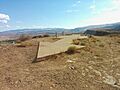
These are the remnants of Transcontinental Air Mail Route Beacon 37A, which was located atop a bluff in St. George, Utah, U.S.A. With concrete arrows indicating the direction to the next beacon, a rotating light tower, and a shed that usually held a generator and fuel tanks, these beacons were once situated every 10 miles on air routes across the United States beginning around 1923.
-
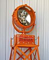
Beacon 61B on a modern display tower, originally installed on route CAM-8 near Castle Rock, WA
