
Trochus Island facts for kids
.jpg)
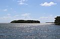
Trochus Island (left) with Turtle Head Island (centre)
|
|

A map of the Torres Strait Islands showing Turtle Head Island in the south eastern waters of Torres Strait, east of the Cape York Peninsula
|
|
| Geography | |
|---|---|
| Location | Great Barrier Reef Marine Park, Northern Australia |
| Coordinates | 10°55′19″S 142°37′48″E / 10.922°S 142.630°E |
| Archipelago | Torres Strait Islands |
| Adjacent bodies of water | Torres Strait |
| Area | 2.10 km2 (0.81 sq mi) |
| Administration | |
| State | Queensland |
| Local government area | Shire of Torres |
| Demographics | |
| Ethnic groups | Torres Strait Islanders |
Trochus Island is a small island in the Torres Strait Islands group. It is part of the amazing Great Barrier Reef Marine Park in Queensland, Australia. This island is located east of the Cape York Peninsula.
Contents
Where is Trochus Island?
Trochus Island is found in Newcastle Bay. This bay is where the Escape River and Middle River meet the sea. It's also close to Jackey Jackey Creek. The island is right next to the Apudthama National Park.
How far is it from other places?
Trochus Island is about 30 kilometers (19 miles) southeast of a town called Bamaga.
How big is the island?
The island is quite small, covering an area of about 2.1 square kilometers (0.81 square miles).
Images for kids
-
A view of Trochus Island.


All content from Kiddle encyclopedia articles (including the article images and facts) can be freely used under Attribution-ShareAlike license, unless stated otherwise. Cite this article:
Trochus Island Facts for Kids. Kiddle Encyclopedia.