
Tropical Storm Danas (2019) facts for kids

Tropical Storm Danas was the fifth named tropical storm during the 2019 Pacific typhoon season. It was known as Falcon in the Philippines. Tropical storms are like strong wind and rain systems that form over warm ocean waters.
How Danas Formed and Moved
On July 11, 2019, a small area of low pressure started to form near the Mariana Islands. This is often the first step in a tropical storm forming.
A few days later, on July 14, the Japan Meteorological Agency (JMA) saw that this area was getting stronger. They officially called it a tropical depression. A tropical depression is a weak tropical cyclone with winds that are not yet very strong. At this time, it was moving west.
By July 15, the JMA gave a gale warning, meaning strong winds were expected. The weather agency in Taiwan also upgraded it to a tropical depression.
On July 16, the system became even stronger. The Joint Typhoon Warning Center (JTWC) officially called it a tropical depression. Later that same day, the Japan Meteorological Agency upgraded it to a tropical storm and gave it the name "Danas." Other weather agencies, like those in China and the Philippines (PAGASA), also called it a tropical storm.
Danas kept getting stronger for a few days. On July 19, the JMA reported that Danas had reached its strongest point. Its winds were blowing at about 85 kilometers per hour (50 miles per hour).
After reaching its peak, Danas started to get weaker. On July 20, it moved over South Korea. When a storm moves over land, it's called "landfall." Danas was a weak tropical storm when it hit South Korea. It quickly became a tropical depression again because the ocean water it was moving over became cooler. Cooler water makes tropical storms lose their power.
By July 21, Danas had changed into something called an "extratropical low" over the Sea of Japan. This means it was no longer a tropical storm. The JMA then stopped giving updates on it.
What Danas Did
Philippines
When Danas was still a tropical depression, it started to affect the Philippines. On July 15, the Philippine weather agency (PAGASA) warned people in northern Isabela Province, Cagayan Province, and the Bataan Islands. They raised a "storm signal number 1," which means strong winds were expected.
As Danas got closer to Luzon, a large island in the Philippines, PAGASA raised a "storm signal number 2" for northern Cagayan Province on July 16. This meant even stronger winds were expected there.
Luckily, Danas moved away from the Philippines. By July 18, PAGASA removed all the storm warnings.
Japan
Danas brought a lot of rain to western parts of Japan, especially to almost all of Kyūshū.
In some places, like Goto, more than 350 millimeters (about 14 inches) of rain fell in just 24 hours. This was as much rain as they usually get in a whole month of July! It was the most rain they had seen in July for a long time.
Korea
On July 20, Danas made landfall in South Jeolla Province, South Korea. It was a weak tropical storm at this point. It caused heavy rain across South Korea. We don't know the exact amount of damage it caused.
More heavy rain continued across South Korea and southwest Japan for another day. Many areas got an extra 50 to 100 millimeters (2 to 4 inches) of rain.
Images for kids
-
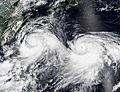
The 2019 Pacific typhoon season featured two simultaneous named storms. Visible in the image is Lekima (left) and Krosa (right) on August 8.
-
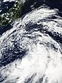
A tropical depression southeast of Japan on September 15


