
South Jeolla Province facts for kids
Quick facts for kids
South Jeolla Province
전라남도
|
||
|---|---|---|
| Korean transcription(s) | ||
| • Hangul | 전라남도 | |
| • Hanja | 全羅南道 | |
| • McCune‑Reischauer | Chŏllanam-do | |
| • Revised Romanization | Jeollanam-do | |
|
||
 |
||
| Country | South Korea | |
| Region | Honam | |
| Capital | Muan County | |
| Subdivisions | 5 cities; 17 counties | |
| Area | ||
| • Total | 12,247 km2 (4,729 sq mi) | |
| Area rank | 3rd | |
| Population
(October, 2014)
|
||
| • Total | 1,902,324 | |
| • Rank | 6th | |
| • Density | 142/km2 (370/sq mi) | |
| Metropolitan Symbols | ||
| • Flower | Camellia japonica | |
| • Tree | Ginkgo | |
| • Bird | Oriental turtle dove | |
| ISO 3166 code | KR-46 | |
| Dialect | Jeolla | |
| Website | jeonnam.go.kr | |

South Jeolla Province, also known as Jeonnam, is a province in South Korea. It is located at the southwestern tip of the Korean Peninsula. South Jeolla is part of the Honam region.
In 2014, about 1.9 million people lived in South Jeolla. The province covers an area of 12,247 square kilometers (about 4,729 square miles). It is the third largest province in South Korea by area.
South Jeolla shares borders with other provinces. To the north, it borders North Jeolla. To the northeast, it borders South Gyeongsang. To the southwest, it faces Jeju Province across the Korea Strait.
Muan County is the capital city of South Jeolla. Yeosu is the largest city in the province. Other important cities include Suncheon, Mokpo, and Gwangyang. Gwangju used to be the biggest city and the historic capital. However, it became a special "Metropolitan City" in 1986. The provincial government then moved to Namak in Muan County in 2005.
Contents
History of South Jeolla
South Jeolla Province was created in 1896. Before that, it was the southern part of the older Jeolla province. Jeolla was one of the Eight Provinces of Korea.
This area remained a province of Korea until 1945. After that, it became part of South Korea. As mentioned, Gwangju was the capital for a long time. But in 2005, the main provincial office moved to Namak in Muan County.
Geography and Nature
South Jeolla is located in the Honam region of Korea. To its west is the Yellow Sea. To the north, it borders Jeollabuk-do Province. The Jeju Strait is to its south. To the east, it borders Gyeongsangnam-do Province.
Islands and Coastline
The coastline of South Jeolla is very long, about 6,100 kilometers (3,800 miles). There are almost 2,000 islands along this coast. About three-quarters of these islands do not have people living on them. The sea around South Jeolla is important for marine products. For example, oyster and seaweed farming are very big industries here.
Land and Farming
The province is not entirely mountainous. There are large flat areas, called plains, along the Seomjin, Yeongsan, and Tamjin rivers. These plains are excellent for farming. They are often called a "granary" because they produce so much food.
The area gets a lot of rain, which helps crops grow well. South Jeolla also has the warmest weather on the Korean Peninsula. This warm climate helps farmers grow many different crops. The main crops are rice, wheat, and barley. Farmers also grow pulses, potatoes, vegetables, cotton, and fruits.
Natural Resources and Industry
A small amount of gold and coal is mined in the province. Besides farming and mining, other industries have also grown in the area.
Climate Conditions
The coastal areas of South Jeolla have a mild and humid climate. The average yearly rainfall is about 1,289 mm (50 inches). Temperatures usually range from 13 to 14 degrees Celsius (55 to 57 degrees Fahrenheit). Summers are wet and windy. Winters are dry. The western side of the Sobaek mountain range gets a lot of snow.
Images for kids
-
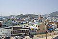
Yeosu
-
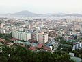
Mokpo
-
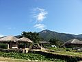
Nagan Eupseong Folk Village in Suncheon


See also
 In Spanish: Provincia de Jeolla del Sur para niños
